Small swells, larger and stormy from late next week

Western Australia Surf Forecast by Craig Brokensha (issued Friday 18th May)
Best Days: Swell magnets in the South West Sunday morning, early Monday, early Tuesday, all locations early Wednesday
Recap
Small clean leftovers across the Margs coast yesterday, best suited to magnets and tiny to the north.
Today a slight kick in new swell has provided better 3-4ft waves across the South West with clean conditions.
Today’s Forecaster Notes are brought to you by Rip Curl
This weekend and next week (May 19 – 25)
These notes will be brief as Ben’s on holidays.
This morning's small spike in swell is due to ease through the day, small to tiny into tomorrow morning with favourable early winds across the South West.
A slight increase in background swell may be seen Sunday and Monday morning but not above 2-3ft, ahead of a small new mid-period W/SW swell Tuesday.
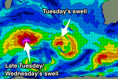 This has been generated by a weak mid-latitude front and should kick Monday afternoon though with N'ly winds, peaking Tuesday to 3-4ft at magnets in the South West, 1ft in Perth and Mandurah.
A better W/SW groundswell is then due late in the day Tuesday, peaking early Wednesday produced by a stronger fetch of severe-gale to storm-force W'ly winds projecting towards us, north of the Heard Island region today.
Though inconsistent we should see a late kick to 4-6ft across the South West Tuesday and 1-2ft sets in Perth and Mandurah, easing back from 5-6ft and 2ft respectively Wednesday morning.
Winds still look dicey an afternoon N/NE breeze Tuesday and dawn E/NE tending fresh N/NE winds Wednesday.
Now, of much greater importance is a flurry of winter calibre storms later next week and into the weekend through the south-east Indian Ocean, owing to a strong node of the Long Wave Trough developing to our west.
We'll have a closer look at this on Monday though, have a great weekend!