Great easing surf over the coming days, fun swells for the weekend and large Monday

Western Australia Surf Forecast by Craig Brokensha (issued Wednesday 9th May)
Best Days: Thursday, Friday morning across the South West and Mandurah, Saturday morning, Sunday morning, Monday
Recap
 Not the best conditions across the South West yesterday with OK surf on the northern end of the cape with favourable winds and 3-4ft of leftover swell. Mandurah was much better with clean 2ft+ waves and 2ft surf in Perth.
This morning is playing out just as expected. We've got a new long-period SW groundswell due to build through the day (afternoon around Perth) with all day offshores. Margs was a clean 5-6ft this morning with some bigger sets now showing, with 2ft waves in Mandurah, 1-2ft Perth.
We should see the swell building to 8-10ft across the South West this afternoon, a strong 3ft in Mandurah by dark, with 2-3ft sets in Perth as winds remain favourable.
Today’s Forecaster Notes are brought to you by Rip Curl
This week and weekend (May 10 - 13)
This afternoon's SW groundswell is due to peak overnight and ease from 6ft to maybe 8ft across the South West tomorrow morning, 2-3ft in Mandurah and 2ft around Perth.
Winds will be great all day, favouring selected spots and fresh from the E/NE.
Friday will be good again through the morning with an E/NE breeze with smaller amounts of swell ahead of a new W/SW groundswell later in the day.
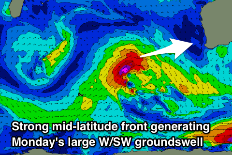
This W/SW groundswell and reinforcing pulses for Saturday afternoon and final larger swell Monday will be generated by a broad and persist flurry of strong storm activity through the Indian Ocean.
The first swell for later Friday and Saturday morning will be least consistent, generated south-east of South Africa and Madagascar, in our far swell window, but we'll see a secondary burst of W/SW gales push closer towards us north of the Heard Island region today and tomorrow.
 This will generate a secondary similar size and more consistent W/SW swell for Saturday afternoon and early Sunday.
Monday's swell will then be generated by a final great fetch of gale to severe-gale W/SW winds projected right towards us through Thursday, Friday and Saturday, dipping south-east through Sunday.
The storm will dip south-east as its blocked by a strong high and this will help produce more favourable winds for when it fills in.
Coming back to the first swell though, an afternoon kick to 4-6ft is expected across magnets in the South West, 1-2ft Perth and Mandurah, with Saturday coming in more around 5-6ft and 2ft respectively.
We'll likely see a drop in size Sunday from 4-6ft across the South West, but Monday's large W/SW groundswell will kick to a much stronger and larger 8-10ft into the afternoon, with 3ft sets in Mandurah and 2-3ft waves in Perth.
Winds Saturday will swing from an early NE breeze to the W, with variable breezes more than likely Sunday morning and then SE winds Monday morning, freshening from the S/SE into the afternoon. We'll confirm this Friday though.
Comments
There's the swell!