Pumping waves Wednesday afternoon and Thursday morning

Western Australia Surf Forecast by Craig Brokensha (issued Monday 7th May)
Best Days: Perth and Mandurah tmorrow, Wednesday, Thursday, early Friday across the South West, Saturday morning
Recap
Clean small waves across magnets in the South West Saturday while Sunday saw stormy building levels of NW windswell across all coasts, with a building SW groundswell in the South West.
Today was the day to surf though as a high moved in quickly behind the low linked to the weekend's windswell, along with a peak in SW groundswell.
The South West saw lumpy and improving waves to 8ft, while Perth and Mandurah pumped with 3ft sets.
Today’s Forecaster Notes are brought to you by Rip Curl
This week and weekend (May 8 - 13)
Moving into tomorrow and we'll see small leftover surf across the South West with a lingering onshore wind from the W/SW.
Perth and Mandurah should see easing 1-2ft sets and clean conditions with an E/SE offshore.
Moving into Wednesday and we're looking at our good new long-period SW groundswell.
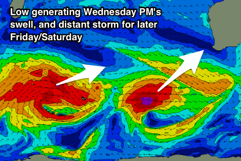
From late last week and through the weekend, a strong polar low pushed through the southern Indian Ocean. Initially strong and generating winds in the severe-gale to storm-force range, it weakened before re-strengthening between us and Heard Island.
The low is still generating a good fetch of severe-gale to storm-force W/SW winds and with this we'll see a large long-period SW groundswell filling in Wednesday, building noticeably from late morning and peaking late in the day.
The models are over-forecasting the raw size of the swell, with background mid-period energy merging with the new long-period swell, but in any case we should see Margs building to a strong 8-10ft across exposed breaks with 3ft sets in Mandurah, 2-3ft in Perth.
 The swell should then ease from 6ft to maybe 8ft early Thursday across the South West, 2-3ft in Mandurah and 2ft around Perth.
Conditions are looking great though with all day offshore E tending E/SE winds Wednesday and then fresh E/NE winds Thursday.
The swell will continue to ease into Friday morning ahead of a new W/SW groundswell building through the afternoon and peaking Saturday.
This is being generated by a broad and strong storm between South Africa and Heard Island. This storm will however weaken before really pushing east past Heard Island resulting in a fair bit of swell decay.
There'll be a bit of west in the swell, with Margs due to build to 4-6ft late Friday, with 5-6ft surf Saturday, and 2ft waves in Mandurah and Perth.
Winds are due to be offshore early Friday, but a trough will move through during the day with S/SE-SE winds on Saturday morning. We'll have to review this on Wednesday though.
Longer term a re-intensification of the remnants of the broad strong storm may generate a large W/SW groundswell for Sunday/Monday, but we'll have a closer look at his Wednesday.