Large swells this period with suss winds

Western Australia Surf Forecast by Craig Brokensha (issued Monday 9th April)
Best Days: Perth and Mandurah Tuesday and Wednesday mornings, protected spits later Friday, Saturday and Sunday morning, next week at magnets
Recap
Poor conditions over the weekend with small to tiny surf and onshore winds.
Today is similar though we've got a building swell across all regions with poor onshore winds.
Today’s Forecaster Notes are brought to you by Rip Curl
This week and weekend (Apr 10 - 15)
Today's increase in size is mostly windswell and strengthening mid-period swell from a weakening front linked to tomorrow's SW groundswell pushing into the state.
This front will clear to the east tomorrow, but another very weak front is forecast to move in from the west, keeping onshore winds lingering across the South West, freshening through the day. Perth and Mandurah may see dawn SE winds, and swell wise, we should see 2ft to occasionally 3ft waves across Mandurah, a touch smaller in Perth and 6-8ft waves across the South West magnets.
A drop in size is due through the day, easing back from 4-6ft Wednesday across the South West, 2ft in Mandurah and Perth on the sets. Winds will be great across Mandurah and Perth through the morning with E'ly offshores, while Margs looks to linger onshore from the SW.
Thursday looks to be a lay day as the swell continues to ease and a front clipping the South West brings onshore W/SW tending SW winds too all locations.
Of greater importances are the large swells due late week and into the weekend across the state.
Yesterday, a vigorous mid-latitude low formed south-east of South Africa and is now generating a fetch of severe-gale W/SW winds in our far western swell window.
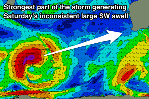 This low will track south-east while continuing to generate similar strength winds, passing across the Heard Island region before weakening and pushing up towards us Thursday and Friday a little ahead of the swell its created.
This track is quite nice and along the West Oz Great Circle Path, with the strongest and initial part of the storm generating a large long-period SW groundswell for Saturday. This should come in at a large inconsistent 10ft on the sets across the South West reefs, 3ft in Mandurah and an inconsistent 2-3ft in Perth.
On Friday though we'll see large building surf from the front racing up into the state, building to 8-10ft later in the day across Margs (6ft+ range earlier), 2-3ft in Mandurah and Perth. Winds will poor and gusty from the S/SW across the South West (S/SE around Mandurah and Perth) tending S/SW into the afternoon.
Come Saturday conditions should be better across all coasts but not great with a lighter morning S/SE breeze across the South West, more SE further north.
We're expected to see the swell continue to ease through the weekend, but with a stubborn high to our west will keep winds generally out of the S/SE to S/SW.
Next week is looking much cleaner as the high moves east, but this will also block away any major storms with no significant new swell energy due. We may see a fun sized S/SW groundswell across the South West early next week, but more on this Wednesday.
Comments
whats the story?
Any chance of North Point Fri/Sat?
I don't think so, will be on the lower threshold at best, and inconsistent for the best pulse.
Lower end of the scale size-wise and fairly south too so it's a tough call. It was only Seabass' 10-pointer that salvaged last years decamp, but they can't get that lucky two years running.
Who's going left , that's my call
At Nth Pt...now I'd like to see that.
Looks like it is bang on for North at either Friday arv or Sat morn. Can you confirm angles lads? Looking way more sw than last year, as long as there is west in it to some degree it gets around the cnr.
Looks like around 220°, so just S of SW, and the latest models have knocked some size off it. Craig will have a Margs Pro forecast up shortly which'll cover it in greater detail.
To give you a bit of a comparison, today, nth pnt is about the same size as last years comp.