Poor weekend, average most of next week, with a window Thursday morning

Western Australia Surf Forecast by Craig Brokensha (issued Friday 26th August)
Best Days: Both coasts Thursday morning
Recap
Great waves across the South West through the morning with a new pulse of long-period SW groundswell to 5-6ft along with fresh E/NE winds, these shifted more NE through the day, limiting options. Perth and Mandurah came in at an inconsistent 1ft to occasionally 2ft.

The swell eased through the day, and today conditions were poor with small to tiny leftovers with poor and deteriorating winds.
This weekend (Aug 27 – 28)
The weekend isn't looking too flash at all, with a deepening mid-latitude low to our south-west moving in and across us. This will see onshore W/NW tending S/SW winds across both regions tomorrow and then S'ly winds on Sunday.
As the low moves in from the west, we'll see a fetch of S'ly gales generated in our southern swell window, producing a kick in size later tomorrow, to 6ft+ across exposed breaks, with Perth kicking to a messy 2ft late.
A rapid drop in size is then due Sunday from similar sizes, but there's no chance for decent S/SE breezes across the region.
Next week onwards (Aug 29 onwards)
Monday will see winds tend S/SE across Perth (remaining onshore in the South West from the S/SW) but no decent swell is due to be left across the metro beaches.
Of greater importance is the larger swells due into the rest of the week and weekend.
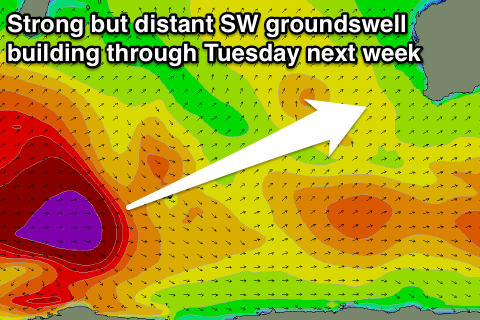 During Tuesday the least consistent of all the swells is due to build, with it being generating by a strong polar low firing up south of South Africa, with this system now stalling south of Madagascar as a secondary flurry of strong mid-latitude fronts piggy-back up over the top of it.
An initial inconsistent but strong long-period SW groundswell will arrive overnight Monday and build Tuesday to an inconsistent 6ft into the afternoon across the South West, and 1-2ft in Perth. Later in the day and Wednesday morning another long-period SW groundswell will be in the mix from a pre-frontal fetch of severe-gale to storm-force W/NW winds developing after one of the piggy-back fronts dips south-east across Heard Island.
This should keep 6ft surf hitting the South West Wednesday morning and 2ft sets across Perth.
The slightly better and more consistent W/SW swell from the piggy-back front is then due Wednesday afternoon and Thursday morning to 6ft+ across the South West.
Unfortunately on Tuesday strengthening NW winds are due across the South West (NE early in Perth), with SW breezes Wednesday. Thursday morning should see a window of early E/NE winds across Margs and Perth before tending more N/NW into the afternoon.
Now into Friday and more so the weekend our final pulse of large W/SW groundswell is expected, generated by a vigorous front firing up on the back of all this activity ahead of it, projecting a series of severe-gale fetches through our western swell window.
A few pulses are due, the biggest for Saturday afternoon/Sunday morning to the 10ft range in the South West and 2-3ft in Perth. Winds won't let up though, with onshores expected, but we'll review this Monday. Have a great weekend!
Comments
Thats some westerly swell aimed at wa and spring time its going to be good