New swell with workable winds tomorrow, average from Friday afternoon

Western Australia Surf Forecast by Craig Brokensha (issued Wednesday 24th August)
Best Days: Both regions Thursday, protected spots out of the north winds in the South West Friday morning
Recap
Offshore winds finally kicked in across the South West yesterday, with a good W/SW groundswell to an inconsistent 6ft to occasionally 8ft, a touch under the expected 6-8ft+. Perth and Mandurah were fun and good most of the day with 2ft sets.
Today the swell has hung in well across Margs and Mandurah to expectations with 6ft sets continuing across the exposed reefs with a fresher E/NE offshore, while Mandurah was holding 2ft. Perth was back to 1-1.5ft+.
This week and weekend (Aug 25 – 28)
Our reinforcing SW groundswell pulse for later today but more so tomorrow morning is still on track with the South West expected to come in around 5-6ft, with 1ft to sometimes 2ft sets to the north.
The swell will ease through the day, smaller into Friday.
Conditions will be best early tomorrow with a fresh E/NE breeze at dawn in the South West, tending NE mid-morning and more N/NE into the afternoon. Friday will then see gusty N/NE tending N/NW winds as an intense mid-latitude low starts moving in from the west.
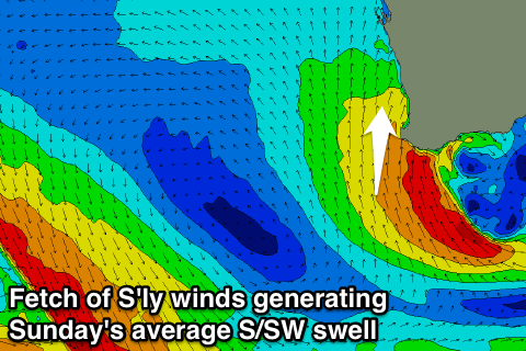 This mid-latitude low won't be favourable for swell production with the western flank producing all the swell, aiming S/SE winds away from us. As it moves east and across us Saturday afternoon and evening, the S/SE fetch will be in Margs swell window, stalling and tending more S/SW through Sunday.
This should produce fresh levels of S/SW for Sunday, easing Monday as the low continues slowly east.
Margs should offer raw and messy 6ft+ waves at exposed breaks along with S/SW winds, fading real quickly into Monday from 3-4ft as onshore S/SW winds persist.
Perth may see 1-2ft waves Sunday, tiny into Monday.
Next week onwards (Aug 29 onwards)
Into the middle of next week we're expected to see a very inconsistent long-range SW groundswell impacting the coast, followed by a more consistent W/SW swell.
These swells will be generated by a vigorous and slow moving polar low firing up under South Africa early this morning.
An initial slow moving polar low will generate a slow moving fetch of severe-gale to storm-force W/SW winds through our far swell window, stalling before a secondary intensification sees a fetch of severe-gale SW winds project more north into the central Indian Ocean.
What will result is an initial long-period and inconsistent SW groundswell, building Tuesday and peaking Wednesday morning to 6ft to sometimes 8ft across the South West and 1-2ft in Perth. The secondary intensification will generate a W/SW swell for Thursday to a similar size.
Conditions will unfortunately be average though with increasing NW winds Tuesday, swinging from the W to SW Wednesday and then back to the NW again Thursday.
Of greater significance is a larger XL swell on the cards for the following weekend all owing to a strong node of the Long Wave Trough, but more on this Friday.
Comments
Pretty nice start to the morning, eh?
From our Yallingup cam: https://www.swellnet.com/surfcams/yallingup
Thundering through at Surfers Point! (well, technically Southside).
https://www.swellnet.com/surfcams/margaret-river