Average winds with plenty of swell

Western Australia Surf Forecast by Craig Brokensha (issued Monday 21st July)
Best Days: Small windows Wednesday and Thursday mornings north of Margs
Recap
The weekend was poor across most breaks with only a short-lived period of favourable winds around Perth and Gero Saturday morning. Sunday was a write off and same with today with onshore winds and building swells around Margs and Perth, although Gero saw a period of favourable N/NE winds this morning.
This week onwards (Jul 21 onwards)
As touched on last week, this week is looking average for surf as a series of mid-latitude fronts push into us from the Southern Indian Ocean.
This will bring with it large pulses of W/SW groundswell but poor winds for the most part as a strong node of the Long Wave Trough moves in and stalls across us through the end of the week/weekend.
The trick will be to surf around the windows of lighter winds and this will be between frontal passages.
So initially a large pulse of W/SW groundswell is due to build through tomorrow but with strong onshore S/SW winds.
The swell should drop through Wednesday and in the wake of the front we should see variable winds develop around Perth and Gero, likely from the SE. Size size Perth should ease from 2-3ft, while Gero should back off from 4-5ft.
Thursday morning will be another opportunity to get wet north of Margs with variable tending offshore winds but a low point in swell activity.
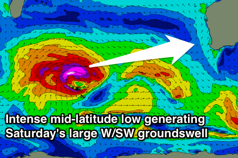 Into the end of the week and more so the weekend, a very large and powerful W/SW groundswell is due owing to a mid-latitude front deepening significantly south-east of South Africa, producing a fetch of severe-gale to storm-force W'ly winds on top of an already active sea state.
We may see this swell arriving later Friday but winds will be poor and strengthening from the N/NW. As the swell peaks Saturday likely in the 12-15ft+ range around Margs, 3-4ft+ in Perth and 8-10ft around Gero, winds will be poor and from the W/SW-SW.
Sunday won't be any better as another front approaches bringing pre-frontal W/NW winds ahead. Another large pulse of W/SW groundswell is due behind this front, filling in Monday, but more on this Wednesday.
Comments
The weekend in Perth actually had good conditions, especially Sun morning with the bump in swell overnight. Caught me out too.
Ah yes it did, just quickly scanned over the Naturaliste and Gero Airport obs, but alas Perth had morning offshores. Small window before a weak change.
Offshore pretty much up until lunch, which is a good stretch here in the west, apparently caught a lot of people out with crowds down which is also unusal, dirty I missed it.
Interestingly BOM is stating onshore winds for Thu so I'm curious to know how you are confident calling it variable to offshore...I'd be more than happy if it is?
Thanks for your forecasts Craig always look forward to reading them.
Thanks Quokka, It looks like there will be a very weak onshore gradient flow and with this, local land breezes should over power the weak W'ly resulting in either variable or at best light offshore winds.
Here's the wind forecast for 8am Thursday and you can see what I'm referring to.
I find the BOM usually forecast the general wind trend and don't mention or pick up local morning fluctuations/features.
Ah nice one, yes agree BOM is usually very general with regard to wind. That does look like it may have some NNE aspect (hopefully more in the E quadrant) to it which is good. Fingers crossed. I'm assuming the wind forecast as above is part of Weatherzone Pro?
Yeah it is unfortunately. More than worth it if you're doing your own wind forecasting though.
BOM has localised wind forecasts freely available though, using ECMWF data from Day 3 onwards.
http://www.bom.gov.au/marine/wind.shtml
Cheers Craig, that's handy to know.
Quokka, looks to have come off as expected on Monday, and even real close to my forecast notes yesterday.
"a moderate S/SW'ly likely to linger early morning. We should see this backing off through the morning though and possibly tending S/SE before reverting back to the SW into the afternoon."
Winds were 11-15kt SW up until 5:30am but have since shifted S/SE and even E/SE.
Nice one, unfortunately I couldn't cash in today as the offshore kicked in too late and it wasn't good enough to chuck a sickie!
Agree, looked knocked up, lumpy and all over the place.