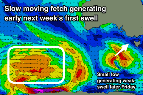
Good tomorrow, average from Friday through until early next week

Victoria Forecast by Craig Brokensha (issued Wednesday 24th October)
Best Days: Early east of Melbourne tomorrow, Surf Coast all morning, east of Melbourne Monday morning, both coasts Tuesday
Recap
Fun waves on the Surf Coast yesterday morning with a drop in swell back to 2-3ft ahead of a strong onshore change, while locations to the east were also workable with light morning winds.
Today our solid mix of W/SW and SW swell are filling in but conditions aren't ideal with onshore winds across most locations, workable around Torquay this morning for keen surfers.
Today’s Forecaster Notes are brought to you by Rip Curl
This week and weekend (Oct 25 - 28)
The mid-latitude storm linked to today's mixed W/SW and SW swells is currently passing under Tasmania and we'll see a peak in size through the day today, with an easing trend tomorrow, further into Friday morning.
The Surf Coast should still see 3-4ft sets at swell magnets early tomorrow, smaller and back to 2-3ft into the afternoon with easing 6ft sets on the Mornington Peninsula with local offshore winds.
An early N/NE breeze should be seen on the Mornington Peninsula, N/NW on the Surf Coast, with winds tending more NW through the late morning ahead of a W/SW-SW change early afternoon.
This change will be linked with a small low forming south-west of us tomorrow morning, pushing east under Tassie with a weak front attached to it.
 A small spike in weak mid-period SW swell is due from the low Friday afternoon, keeping small 2ft waves hitting the Surf Coast and 3ft to occasionally 4ft sets to the east. Winds will be generally onshore Friday and from the SW apart from an early W/NW'ly around Torquay and small 2ft leftovers.
Saturday will be cleaner for longer with a W/NW offshore holding until early afternoon but the surf will be small and weak, easing from 2ft max on the sets on the Surf Coast, 3ft+ to the east.
The deepening inland surface trough and low that was expected to bring an onshore change and stormy windswell for the weekend and early next week now looks to just remain as a surface trough, with a polar front instead pushing up from the south Saturday evening.
This will bring S/SE winds on Sunday with no new decent swell, while Monday winds look to swing more E/NE along with a new inconsistent SW groundswell.
The source of this groundswell will be a distant and stalling polar fetch of W-W/NW gales east of Heard Island and south-west of Western Australia.
Size wise we should see a late kick in swell Sunday ahead of a peak Monday morning to 2ft to occasionally 3ft on the Surf Coast swell magnets and 4ft+ to the east. Later in the day we're likely to see a stronger SW groundswell generated by a gale to severe-gale W/NW fetch projecting east-southeast in a similar area to the storm before it, but closer towards us.
Better sets to 3ft+ on the Surf Coast and 4-5ft+ on the Mornington Peninsula are due, under a N-N/NW breeze. We'll have to confirm this on Friday though.
Comments
What are your wind forecasts based on? Went onshore early this morning, the offshore never really got going. Willy weather had this pegged 2 days ago. I thought it would have been from the same data?
I look at a range of different models, and hi-res a day or two out and yesterday morning it still had N/NE tending N/NW and then W/SW winds.
It looks like a small surface trough stuffed with the flow this morning, it's a transition period and these little funky troughs sometimes mess with the winds.
I don't take wind forecasts lightly as they make or break a surf across most coasts.
Take one look at the forecast model for 8am this morning, very tricky and more variable then yesterday was indicating.
Thanks Craig, looks like a dogs breakfast! Stayed reasonably light so could have been worse.
Interesting how most Victorian coasts' AWS actually reported offshore wind directions for at least a few hours this morning, so if you looked at them in isolation (or in realtime) you'd have thought it could be pretty good. Technically these readings may have also validated the model data Craig used to prepare yesterday's notes too. Though that doesn't necessarily reflect real-world surf conditions, which is another curveball for the discipline.
In any case, it's the overnight trend that's important, as well as the regional synoptic flow. For example, locally calm/or light offshores are less useful if the synoptic flow a couple of kays offshore is fresh onshore or crossshore, as the broader airstream will have an influence on the quality of the groundswell.
So, it's important to look at your local AWS for nearshore winds (suggestive of wave face quality, for example), but then also a regional, exposed AWS for a second pass (suggestive of the quality of the actual swell conditions).
In Victoria's case, I always cross reference daily regional conditions via South Channel Island, Cape Otway and King Island, and others depending on the system i.e. perhaps Cape Nelson, and Cape Grim under frontal passages, or Wilsons Prom and Hogan Island under an easterly). But if looking for terrestrial influences and local effects, then Aireys Inlet, Cerberus, Rhyll, Port Fairy etc are your best choice.
It was offshore along the Bellarine this morning (at least between 6-8am when I was there). Was pretty lumpy though from yesterday's onshores.