Large powerful groundswell inbound but winds are an issue

Victoria Forecast by Craig Brokensha (issued Monday 1st October)
Best Days: Beaches and locations east of Melbourne tomorrow, Surf Coast Wednesday morning
Recap
Good fun waves all weekend across the Surf Coast with morning offshores and a peak in mid-period W/SW swell Saturday, stronger and from the SW yesterday.
The swell kicked further into the afternoon with a peak in the best groundswell seen this morning around 4-5ft on the Surf Coast swell magnets and 6ft+ to the east with good winds for most locations.
The swell should persist all day as winds come up from the E/SE mid-afternoon.
Today’s Forecaster Notes are brought to you by Rip Curl
This week and weekend (Oct 2 - 7)
Yesterday and today's SW groundswells were generated by great elongated pre-frontal fetches of W/NW gales and with a peak seen during today, a slow drop in size is expected tomorrow from 3-4ft on the Surf Coast and 5-6ft on the Mornington Peninsula.
A developing morning E/NE tending NE breeze will favour the beaches across both regions, likely holding into the afternoon as a mid-latitude low starts moving in from the west.
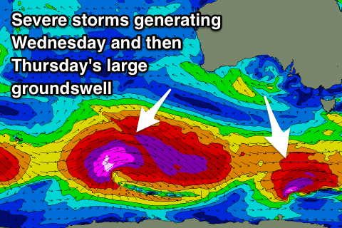
Our new long-period SW groundswell for Wednesday and larger swell for Thursday are still on track, but so are the onshore winds.
We've currently got a series of severe storms spread out along the polar shelf extending from the south-western of Tassie to the southern Indian Ocean.
 The system linked to Wednesday's swell is producing a fetch of severe-gale W'ly winds on top an active sea state, with a long-period SW groundswell due to arrive early morning, keeping the Surf Coast magnets coming in at 3-4ft, with 5-6ft sets on the Mornington Peninsula.
Winds will be best for the Surf Coast through the morning and offshore from the NW, tending W/NW ahead of a midday W/SW-SW change as the mid-latitude low continues further east.
This change and low will then stall off the southern NSW coast and direct poor onshore S/SW tending SE breezes across both regions into Thursday as our large and powerful SW groundswell fills in.
The groundswell is being generated by the strongest of the polar storms with a significant and broad pre-frontal fetch of severe-gale W/NW winds setting up an active sea state for post-frontal severe-gale to storm-force W/SW winds to move over, traversing east under the country and then under Tasmania.
A large, powerful and long-period SW will be generated, filling in Thursday and peaking to 6-8ft across the Surf Coast swell magnets and 10ft+ to the east though with this poor onshore winds.
Unfortunately the low will continue to dominate our local winds through the end of the week and weekend as it sits off the southern NSW coast as the large SW groundswell eases, slowed by reinforcing S/SW pulses Friday afternoon and Sunday.
Onshore E/SE-SE winds will be seen Friday with easing surf from 4-6ft on the Surf Coast and 6-8ft to the east, possible E/NE Saturday morning with a further drop in size.
A return to SE winds is expected on Sunday and Monday as a strong high moves in from the west as the swell continues to ease. More on this Wednesday though.
Comments
I did notice one wave today that made me do a double-take as it was decently sized and very hollow. Plenty of power in the swell last couple of days, very clean at times too. On dusk yesterday and the really low tide I saw one bombie start breaking that you wouldn't really expect to on the sizes the swell was judged to be...
Gary has a feeling in his loins that much like one of Gary's parties, things are gonna get funky tomorrow a little earlier than you're expecting.
Thoughts?
Yep, winds look like being W/NW at dawn, then swinging onshore by mid-morning or so.