Large building swells with great conditions

Victoria Forecast by Craig Brokensha (issued Monday 17th September)
Best Days: Surf Coast tomorrow, Wednesday, Thursday morning and Saturday morning
Recap
Good waves for protected spots over the weekend with an initial increase in inconsistent SW groundswell Saturday morning with strong and tricky W/NW winds, shifting more W-W/SW through the afternoon.
Sunday saw a new mix of W/SW and SW swells fill in with great though slightly raw waves across the Surf Coast reefs most of the day.
This morning the swells were on the ease but lined up super nice with easing sets in the 4ft range on the Surf Coast and 6ft on the Mornington Peninsula.
Today’s Forecaster Notes are brought to you by Rip Curl
This week and weekend (Sep 18 - 23)
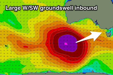
Looking at the week ahead and we've got excellent waves due across the Surf Coast tomorrow as a large and powerful long-period W/SW groundswell fills in under favourable winds.
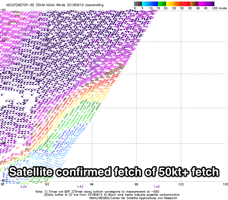 This swell started to be generated late last week as a vigorous low developed in the Heard Island region, deepening and projecting a fetch of severe-gale to storm-force W/SW winds through our medium range swell window, with the low currently weakening while projecting up towards the Bight.
This is a slight change in direction to what was forecast on Friday, and with this there's been a very slight downgrade in the expected size due off the swell.
With winds being so strong for a good period of time, we've got a great long-period groundswell inbound with the forerunners due to arrive early tomorrow morning ahead of the bulk of the groundswell into the late afternoon, with a peak due overnight.
 The Surf Coast is due to build from the 2-3ft range early to a strong 5-6ft by dark, with building surf from 4-5ft on the Mornington Peninsula to 8ft on the sets by dark.
Winds will swing from a gusty N/NW'ly early morning to the W/NW through the day, keeping the Surf Coast clean and pumping as the swell kicks.
A slow easing trend is expected through Wednesday from a similar 5-6ft on the Surf Coast magnets and 8ft on the sets across the Mornington Peninsula with a W/NW-W breeze, possibly tending W/SW through the afternoon with a shallow change.
Thursday looks to see similar winds as the swell continues to drop, more noticeably from the 3ft+ range on the Surf Coast magnets and 4-6ft respectively.
Persistent W/NW winds will continue to favour the Surf Coast on Friday with smaller fading surf.
Later in the day we may see a new S/SW groundswell showing across the region but Saturday morning is a much better chance for this with it generated by a strengthening polar low late in our swell window Wednesday evening. A fetch of severe-gale W'ly winds will be generated south-west of Tassie, with the swell peaking Saturday morning to a good 3ft on the Surf Coast and 4-5ft to the east.
Winds at this stage look best for the Surf Coast and out of the W/NW ahead of a SW change, with onshores on Saturday as some new SW swell starts to fill in.
This SW swell and following pulses of S/SW swell energy are expected into early next week as winds slowly improve and tend NE, but more on this Wednesday.
Comments
BOM saying 45 knot gusts possible tomorrow avo...
Hey Craig are you still expecting this new swell to kick in for the surf coast this afternoon? I haven't seen much of a significant rise in the cape sorell buy data yet.
Yes, key word being late in the notes above.
Cheers! Fingers crossed that wind swings at in time.
First signs on Sorell.
I allow about a 5 hour lag between Sorell and the Surf Coast. I reckon it is going to struggle to make a lot of impact before the sun goes down…
Starting to kick..
Not showing on the Nepean buoy, but there seems to have a lag in being updated. Is my estimate of 5 hours too long? I assume this varies with the wave period...
Buoy frustratingly hasn't updated since 8:30am.
Yeah for this direction and period.
The forecast was spot on. I was in the water at 4pm and it was a solid 4ft. Super powerful swell.
Thanks Shane, good sets still out there this morning on the high tide.