Building westerly swells, dropping back through next week

Victoria Forecast by Craig Brokensha (issued Friday 3rd July)
Best Days: Surf Coast and select locations to the east Sunday, Surf Coast Monday onwards
Recap
Wednesday's mix of swells dropped rapidly through yesterday with 3ft sets at dawn on the Surf Coast and 4-5ft'ers east of Melbourne, down to 1-2ft and 2-3ft respectively by the afternoon.
Come this morning the strait is as small as it gets with effectively flat conditions on the Surf Coast and tiny waves to the east.
Today’s Forecaster Notes are brought to you by Rip Curl
This weekend and next week (Aug 4 - 10)
Want to receive an email when these Forecaster Notes are updated? Then log in here and update your preferences.
Later today we may see a small new inconsistent W/SW groundswell arriving across the state, but with winds swinging W/NW, conditions at exposed breaks will be average, and the Surf Coast tiny.
Tomorrow is a better chance for more size, but keep your expectations low as the swell will be inconsistent and out of a westerly direction, generated in our far swell window west of WA.
The Surf Coast swell magnets open to west swell should see infrequent 2ft sets all day, with 3-4ft sets on the exposed Mornington Peninsula beaches.
A fresh to strong N/NW wind is due to swing more N'th mid-late afternoon creating an improvement in conditions east of Melbourne.
 A longer-period though still very inconsistent W/SW groundswell is due to arrive late Saturday and provide a touch more energy Sunday morning. This was produced by a vigorous storm in the southern Indian Ocean and will be very inconsistent, mixed in with hopefully some slightly better mid-period W/SW energy ahead of a strong long-period W/SW groundswell into the afternoon.
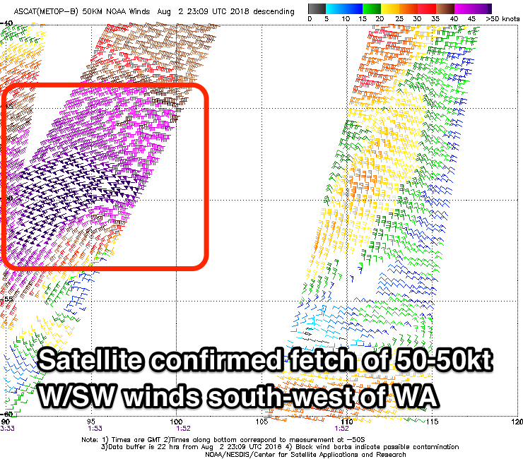
As touched on Wednesday, we've had an upgrade in the W/SW groundswell event due from Sunday through early next week owing to the development of a severe-low south-west of Western Australia yesterday.
We've seen a fetch of storm-force W/SW winds move over the top of an active sea state, with satellite observations confirming core wind speeds to 50-55kts.
This low is continuing to generate storm-force W/SW winds through our western swell window while projecting slowly east-northeast, with it forecast to stall under the WA coast this evening.
We'll continue to see severe-gale W'ly winds aimed in our acute western swell window before the low takes a more meridional (south to north) structure, aiming the fetch away from our swell window.
The low will slowly weaken while pushing east through the weekend and early next week, but mostly out of our swell window.
What we can expect is a moderate to large long-period W/SW groundswell to arrive later Sunday morning, kicking strongly into the afternoon ahead of a peak overnight. With the low generating a more acute reinforcing W'ly swell Monday we'll see the size ease back through Monday most noticeabaly on the Surf Coast, smaller again into Tuesday.
Size wise the Surf Coast is likely to be a slow 2-3ft at magnets Sunday morning with 4-5ft sets to the east from the long-range and mid-period energy, quickly overridden by the stronger long-period W/SW groundswell into the afternoon. We should see the Surf Coast reach 4-5ft by dark with 8ft sets on the beaches to the east under a fresh and gusty and persistent N/NW breeze.
 Monday morning looks a touch smaller with easing sets from 3-5ft on the Surf Coast swell magnets and 6-8ft on the Mornington Peninsula under a gusty NW tending W/NW breeze.
Tuesday will become smaller again as the acute W'ly swell eases, mixed in with some small W/SW windswell as the weakened mid-latitude low pushes across us.
We're looking at smaller 2-3ft waves on the Surf Coast and 4-5ft+ sets to the east with a W/NW breeze, possibly tending more NW into the afternoon with an approaching mid-latitude front.
This mid-latitude front and following activity through the rest of the week won't have too much structure, fetch length or breadth to them and as a result we're looking at mid-period W/SW swells without too much size but with favourable NW winds for the Surf Coast.
A steady run of fun sized surf should be seen, likely biggest Thursday, but we'll have a closer look at this on Monday. Have a great weekend!