Windy westerly swells persist

Victoria Forecast by Craig Brokensha (issued Monday 30th June)
Best Days: Keen surfers Surf Coast tomorrow morning, Surf Coast Wednesday, both coasts Thursday, east of Melbourne Friday, Saturday afternoon and Sunday
Recap
Easing surf over the weekend with good winds for both regions Saturday, while Sunday was a lay day with a low point in swell and strengthening W/NW winds ahead of a deep and powerful mid-latitude low.
This low upgraded slightly in strength from Friday and as a result we've seen slightly more swell than forecast Friday with clean though raw 3-5ft waves on the Surf Coast and choppy 6ft+ waves to the east. A long-range and inconsistent W/SW groundswell is also in the mix, though hard to distinguish under the localised energy.
Today’s Forecaster Notes are brought to you by Rip Curl
This week and weekend (Jul 31 – Aug 5)
Want to receive an email when these Forecaster Notes are updated? Then log in here and update your preferences.
The mid-latitude low responsible for this morning's spike in close-range swell has moved off quickly to the east and as a result we'll see the swell easing steadily through the day, as the long-range and inconsistent W/SW groundswell hangs in there.
Into tomorrow both swells will continue to ease, dropping from a smaller 2ft+ on the Surf Coast tomorrow morning and 3-4ft+ on the Mornington Peninsula.
 An approaching mid-latitude front will bring gusty NW winds, swinging more W/NW through the afternoon while strengthening.
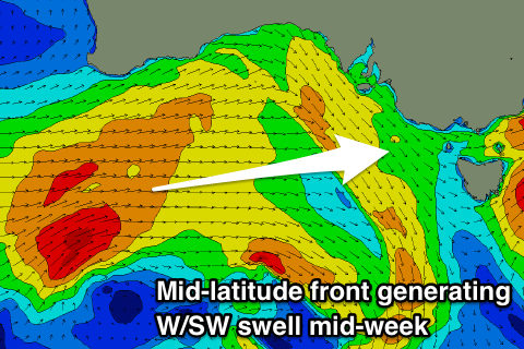
This mid-latitude frontal progression developed in the Indian Ocean last week and pushed east through the weekend, with a fetch of strong to gale-force W/SW winds generated under WA, through our western swell window.
The front has weakened while continuing east closer towards us and will push through tomorrow, followed by a secondary embedded trailing front, produce a burst of W'ly gales through our swell window into the afternoon and evening.
What we should see is a mix of building W/SW swells through Wednesday, likely biggest and strongest into the afternoon.
The Surf Coast is expected to build to 3ft to sometimes 4ft at swell magnets open to the west swell, with 6ft+ waves to the east. Conditions will be best for protected spots with a morning W/NW offshore, likely tending variable into the afternoon.
As touched on in Friday's notes, we'll see gusty and possibly strong N/NE winds as a vigorous mid-latitude frontal system pushes in from the west.
This will create tricky conditions into the afternoon with the mix of swells easing back from from the 3ft range on the Surf Coast and 4-5ft on the Mornington Peninsula.
Friday morning will be smaller again (small to tiny Surf Coast and 2ft to maybe 3ft to the east) with strong N/NE tending N/NW winds as the mid-latitude front nears closer.
No new swell is due once the mid-latitude system pushes across us, with it weakening and being located too north to produce any swell generating fetch.
A small inconsistent W/SW groundswell from the earlier stages of the progression south-west of WA is due to fill in later Friday afternoon and peak Saturday. Size wise, there's not expected to be much above 2ft on the Surf Coast and 3-4ft on the Mornington Peninsula under a fresh and gusty N/NW tending N'ly breeze.
A slightly better W/SW swell generated by pre-frontal W/NW gales moving through our western swell window, south-west of WA later this week should provide a touch more size on Sunday, stronger Monday from a trailing fetch of severe-gale W/SW winds.
Inconsistent 2-3ft sets are likely on the Surf Coast Sunday with 4-5ft sets to the east with a favourable N/NE offshore breeze. Winds Monday look a little funky, but more on this Wednesday.
Comments
Cheers winter.
Hi Craig, Would you expect the wind to be poor for the Torquay reefs on Sunday?
Yeah they look too north at this stage. We've also had an upgrade in the west swell due Sunday, which I'll outline tomorrow.
Hi Craig, what are the current models saying for Wednesday re wave height and wind direction?
You can see that here Heath.. https://www.swellnet.com/reports/australia/victoria/torquay/forecast
so 4-5ft and WSW should be spot on for the Surfcoast tomorrow morning?
I've detailed what I expect tomorrow in the notes above.
Hi Craig,
I'm too cheap to get a subscription. What's the surf going to be like on Saturday? Is the wind going to be WSW or ENE?
Lets be honest VL. We know we both want ENE