Extended period of windy conditions ahead; looking large from later next week onwards

Victoria Forecast by Ben Matson (issued Friday 29th June)
Best Days: Sun/Mon: offshore west of Melbourne with small to moderate swells. Late Tues/Wed: chance for a new swell west of Melbourne though blustery. Fri onwards: extended period of large, windy surf.
Recap: Wave heights have been generally small for the last few days, though a small rise was reported across some coasts on Thursday, before falling away today.
Today’s Forecaster Notes are brought to you by Rip Curl
This weekend (June 30 - July 1)
Want to receive an email when these Forecaster Notes are updated? Then log in here and update your preferences.
Note: Today’s Forecaster Notes will be brief, as Craig is away on annual leave. Also, these Forecaster Notes will be updated Tuesdays, Thursdays and Saturdays for the next few weeks.
No change to the weekend surf outlook: I’m still not particularly enthused.
The swell window’s been busy over the last few days, but the weather systems are all over the shop, and not particularly strong either. So, although we have a rising swell through Saturday towards a peak on Sunday, it’ll be quite windy (nowhere worthwhile east of Melbourne) and there won’t be a lot of size/strength on the Surf Coast to get overly exited about.
We’ll see a brief window of NW winds at dawn on Saturday, followed by gusty W’ly tending W/SW winds throughout the day. The early morning window will coincide with the smallest time frame all weekend, with inconsistent 2ft waves on the Surf Coast and the afternoon increase will be accompanied by tricky cross-onshore winds.
Winds will veer more NW for Sunday and this will probably offer the best waves of the weekend though without the usual strength we expect from the Southern Ocean. Wave heights should hold a steady 2-3ft across the Surf Coast. It’ll be larger but very wind affected east of Melbourne, without enough size for those locations offering shelter from this breeze.
Next week (July 2 onwards)
A slight reinforcement in groundswell is expected on Monday, though in reality I’m not expecting much more size than what we’ll see on Sunday - perhaps a few bigger sets if we're lucky, though it'l be quite inconsistent. Winds will hold out from the NW so conditions will be clean across the Surf Coast but options will be limited east of Melbourne.
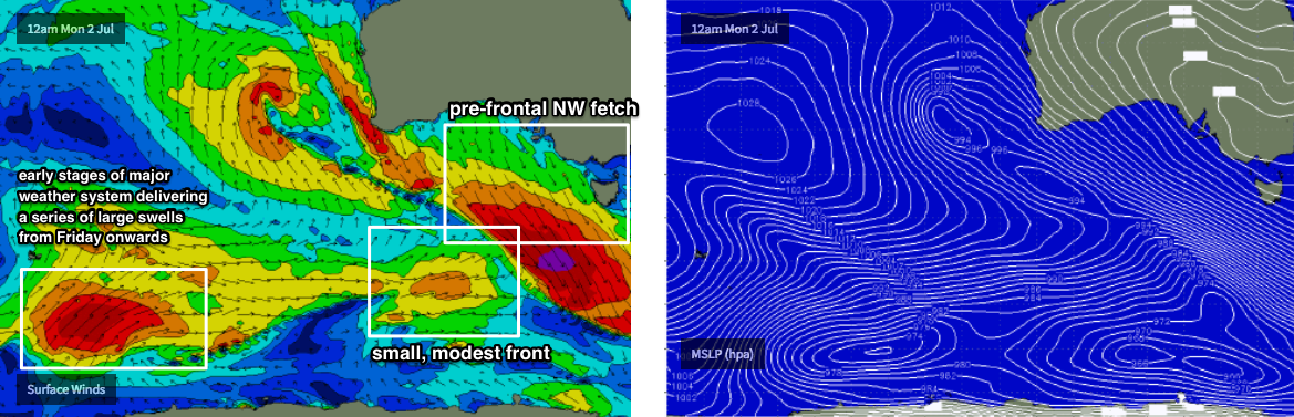
The rest of the forecast period is extremely tricky (though, when does the outlook not throw a curveball or three?). Whilst the Southern Ocean is very busy, most of the promising activity positioned inside our swell window is well to the far west, and thus not in a position to generate any meaningful size.
However, a very broad, strong pre-frontal NW fetch will develop on Sunday and Monday (south of WA) ahead of a poorly aligned, and relatively moderate-strength front. The front itself is rather uninspiring however I’ve sometimes seen unusual W/SW swells spread back from these pre-frontal NW fetches - which somewhat defy convention - though that’s perhaps just due to the way these weather charts are projected on to this kind of map layout. There'll be a series of underlying, overlapping W/SW thru' SW groundswells in the mix too, though having been generated such a long way from the mainland they won't be contributing much size.
As such, despite the charts not showing anything noteworthy through the middle of the week, it’ll be worth keeping late Tuesday and Wednesday open for a possible rise in groundswell across the Surf Coast - let’s pencil in possible inconsistent 3ft+ sets (though I’d be reluctant to plan any highway miles around this event, it’s a low confidence source).
A series of unrelated fronts travelling through the Bight will strengthen N/NW winds locally so it’ll be a blustery affair anyway - good for plumage photos if nothing else, perhaps?
These fronts through the Bight will initially be poorly aligned for our coast but the broader pattern is tilting towards a classic wintereque series of broad, powerful Southern Ocean fronts and lows, that are likely to kick off an extended period of large windy waves across Victoria from Friday or Saturday onwards.
More on that in Monday’s update. Have a great weekend!
Comments
Lorne's a funny kinda place - when it's mackin' across the Surf Coast, it'll be a fraction of the size. But even on small swells like today, there are still lil' peelers.
These still shots are a disappointing aspect of swellnet and even more so when specific conditions are identified. What's the bet there will be a lot more than 4 out next time it's small and offshore?
Seeing these stills have been posted ad hoc for the last five or six years, surely that affect would be seen by now?
For what it’s worth, we’re two hours since my post - enough time for the supposed cause and effect to be felt - and there’s now not a soul in the water.
The Surf Coast is 2-3ft and clean (today’s conditions) every other day through the winter months, so it’s hardly identifying a unique set of circumstances in which there’s a breaking wave at one of Victoria’s most popular seaside destinations.
However as I have mentioned in other articles, these Forecaster Notes (and any associated comments/surfcam pics of this nature) will shortly be behind the paywall anyway.
What is the point of posting these again Ben?
It seems so bizarre. Lorne of all places. You may as well be posting pics of local conditions at Seaford mate.
Also, you've posted images in 2 of the last 3 forecast notes you've issued. Ad hoc?
The point of posting surfcam grabs is is based around forecast verification, and hindcasting.
For example, the forecast for yesterday on the Surf Coast was 2-3ft however early morning it looked undersized (despite regional buoy data inline with expectations).
Because most people check the surf report once throughout the day (in the morning) it would have easy to wake up, read the report and view the surfcams, and then assume that the expected swell didn't deliver - and then write off the rest of the day. However, because surf conditions can change significantly throughout the day, posting this image is a confirmation that the swell appeared to have built since the morning report.
The other reason these surfcam snaps (and other data) are useful is that they're another analytical tool for hindcasting purposes.
Just like many meteorological and oceanographic disciplines, data collection in the near shore surf zone is sparse at best. So at the moment, when studies are done about (for example) how climate change might affect surf conditions in the years to come, we actually don't really know - because there is no baseline dataset to work with.
And as we see time and time again, buoy data (which we've got only 20-30 years worth of data for at some locations) does not necessarily correlate with surf conditions either.
Whilst you may argue the merits of whether we need to know how future surf trends may play out, the fact is that surf conditions are tightly correlated with a wide range of coastal impacts such as erosion.
Therefore, the value in having time-stamped near-shore observations (from surf reporters, or surfcams) is that they help to confirm or deny the computer model predictions and the wave buoy observations. And that will in turn help us understand coastal dynamics a little better.
Cool!
re: verification, isn't that what the cams are for? People can check back in mid morning/afternoon and see real time reports if they want?
re: hindcasting could you just buy a hard drive and save the feeds?
Phew! I'm so glad you mentioned hard drives. I was worried you were going to ask me to fax my handwritten observations to the BOM instead.
can you?
Is it really 3ft and offshore every other day in winter??
I suspect you know full well why there is no one out now, which doesn't alter my point about you commenting on specific locations. Are they click bait?
I reckon you guys do good enough job already, driving up crowd numbers from your computer hundreds of kilometres away, without providing people with this sort of info.
For what it's worth I reckon a lot of surfers who live on the coast can't wait for your forecasts to go behind the paywall.
Hey Josey. Let em have Lorne point. Might take a few away from the better breaks on the coast. Which is pretty much every other break between pt Lonny and cape Otway.
Yeah you're right Greyhound.
Just don't think the Swellnet crew need to provide specific info on locations. If it's ok at Lorne point, what's to stop info on other places being provided?
Yeah I reckon get over it chaps, for whatever sake it is Lorne Point we are looking at which is at best, a curiosity. Keep it up Ben the place has been known to all and sundry since at least the mid 70's. Everybody knows which wind, tide and swell it breaks on, and I use that term extremely loosely. Now the break north of Lorne is the real deal.
New FC Notes up now.. batten down the hatches fellas.
https://www.swellnet.com/reports/forecaster-notes/victoria/2018/07/02/th...