Large windy weekend; small clean beachies mid-next week

Victoria Forecast by Ben Matson (issued Friday 15th June)
Best Days: Sat/Sun/Mon: protected spots only. Tues/Wed/Thurs: small clean open beaches. Next weekend onwards: renewal of decent swell for all coasts.
Recap: W’ly swells have limited surf size in Torquay over the last two days (1-2ft building to 2-3ft, very inconsistent) but it’s been quite solid east of Melbourne with wind affected 4-6ft sets at exposed beaches.
Today’s Forecaster Notes are brought to you by Rip Curl
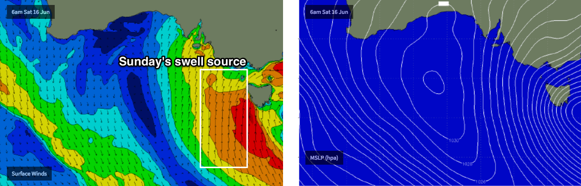
This weekend (Jun 16 - 17)
Want to receive an email when these Forecaster Notes are updated? Then log in here and update your preferences.
Note: Today’s Forecaster Notes will be brief, as Craig is away on annual leave.
No surprises for the weekend, with a significant cold outbreak impacting the entire state thanks to a large, slow moving low south of Tasmania. We’ll see gale force winds from the west early Saturday, veering to the south into Sunday, and a large local swell will concurrently build across all coasts.
The most size is expected on Sunday, mainly because the strongest winds around this low won’t form until Saturday morning, just to the SW of Tasmania. They’ll be quite southerly in direction and the resulting swell direction will also be S/SW, which will narrow the size range we typically see between the Surf/Barwon Coasts and Mornington Peninsula/Phillip Island.
Nevertheless, local conditions will be arctic, and quite blustery. We should see an early period of W/NW winds on Saturday morning, with surf size at a relative weekend low point of 3-4ft+ across the Surf Coast (6ft+ east of Melbourne). Wave heights will increase steadily throughout the day but winds will also back to the W/SW then SW, rendering all but the most protected locations quite bumpy.
Sunday’s larger peak should push north of 6ft to maybe 8ft at most coasts (to be pedantic, perhaps the upper end of this range east of Melbourne, and the lower end west of Melbourne).
However, although we often see early periods of W/NW across the Surf Coast during frontal progressions, I don’t have much confidence this will occur on Sunday morning, due to the strength and position of the parent low - the synoptic flow is expected to be quite strong at this point (from the SW thru’ S/SW) and this will likely override any topographical influences. So, your only surfable options will be inside sheltered locations.
Wave heights will slowly ease throughout the afternoon. Model guidance suggests an afternoon abating of winds east of Melbourne but holding strong to gale force S/SW thru’ S’ly west of Melbourne.
Next week (June 18 onwards)
Easing winds and swells are expected from Monday as the Southern Ocean low tracks to the east, away from our swell window.
Model guidance maintains fresh southerly winds through Monday morning but there is an outside chance for an early period of moderate W/NW winds west from Torquay - however even if this occurs, there will probably be some leftover surface bump to contend with - so don't expect anything great. Size will ease from 3-5ft down to 2-3ft throughout the day here (larger east of Melbourne, with little surfable options with these winds).
Winds are then expected to swing to the east on Tuesday, before a couple of days of freshening northerlies as a weakening front approaches from the west.
Unfortunately, we’re not expecting any major new swells through this time period - the current atmospheric pattern is in a bit of a block, and upstream though our swell window there’s not a lot of favourable storm action east of Heard Island right now. We’ll see a couple of minor long period swells keeping exposed beaches with small surf through the middle to latter part of the week, but there won’t be much surf in Torquay.
The regional block does look like it’ll break down through the first half of next week though, which should lead to a renewal of strong swell activity from next weekend onwards, that should persist for a at least three of four days - with very good surf potential for the Torquay coast. More on this in Monday’s update.
Comments
Will the swell be big enough for lorne pt to work tomorow morning? And will pt impossible 2nd reef still work with the strong winds?
Sorry mate, we don't provide location specific info.
"Nice small waves at Lorne for the early. How's the air temps? 6 degrees at 7am, with wind chill bringing it down to -0.5 degrees........."
Hi Ben,
Ascat data looks fairly good at the moment. https://manati.star.nesdis.noaa.gov/ascat_images/cur_25km_META/zooms/WMB...
What are your thoughts on how this looks for swell direction and timing tomorrow morning?
Eh? Thoughts are above (only a couple of hours old, too). Swell direction and timing isn't the driving factor this weekend, local wind is.
Nice small waves at Lorne for the early. How's the air temps? 6 degrees at 7am, with wind chill bringing it down to -0.5 degrees. I think I've acclimatised a little too well on the Tweed Coast for that kind of guff.

Hi Crag, Where is this wave?
Over near Port Albert I think?
Hi Ben, Can you tell me the best break and exact time to surf tomorrow? What wax do I need? Will the wind be SSW or SW? ( or just send coordinates) and can you send me directions to the break?
Outside fishos bombie, dawn, neap tide, tropical, SS/SW 197deg wind, best suited to a quad or twinzer with a lapcut pinline, make sure to wear 5mm booties + hood + gloves... locals only!!
And can you wax my board & dress me in my wetsuit....please!
Coupla decent waves at Lorne this morning.

Pumping at Lorne this arvo.
Come on Crag, spill the gherkins. Where is this wave at?