Tricky west swells all this week

Victoria Forecast by Craig Brokensha (issued Monday 11th June)
Best Days: Early tomorrow east of Melbourne, Surf Coast Thursday afternoon and Friday
Recap
Saturday was disappointing with our new W/SW groundswell not having any size or power to it, with it looking to have been a little to west in angle initially before swinging more W/SW and coming in at a much better size Sunday morning. Cape Sorell was strong all day but this didn't translate to the expected size in Bass Strait.
Sunday saw good 3ft+ sets across magnets on the Surf Coast during the morning (below) with light winds, while the Mornington Peninsula was a little wobbly, improving through the day.

This morning the swell was back to a tiny 0.5-1ft on the Surf Coast and fun clean 2-3ft at exposed spots east of Melbourne.
Today’s Forecaster Notes are brought to you by Rip Curl
This week and weekend (Jun 12 - 17)
Want to receive an email when these Forecaster Notes are updated? Then log in here and update your preferences.
Moving into tomorrow, we've got our mix of long-range and acute W'ly groundswell mixed in with some shorter-range W/SW swell for the afternoon.
The wind outlook was a little uncertain on Friday but we're now looking at periods of favourable winds for both coasts with an early fresh N/NE breeze due to swing W/NW into the afternoon.
Size wise, the acute W'ly swell isn't expected to offer much on the Surf Coast with infrequent 1-2ft waves during the morning, and 4ft sets to the east, while the shorter-range swell should kick wave heights to 2ft+ at magnets and 5ft on the sets west and east of Melbourne respectively into the afternoon.
We should see the swell ease back into Wednesday from a similar size across both regions, but a gusty N/NW tending NW wind will favour the Surf Coast over the Mornington Peninsula.
Into the end of the week we've got a tricky mix of swells on the cards but with favourable winds for the Surf Coast ahead of strong SW breezes on the weekend.
 Firstly a new mid-period W/SW swell is expected to fill in Thursday, generated by a relatively weak but favourably tracking mid-latitude front from south-west of WA, through the Bight tomorrow and then across us Wednesday evening.
Early morning Thursday not too much sized is expected with maybe 2ft sets on the Surf Coast and 3-4ft+ sets to the east, but the swell should kick to a better 2-3ft at magnets and 4-6ft respectively. A gusty NW wind should keep the Surf Coast clean all day with W/NW winds through Friday.
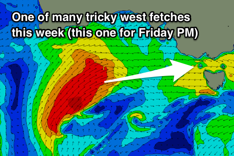
As we move into Friday the mid-period W/SW swell is expected to ease, while a stronger W'ly groundswell fills in, produced by a stronger fetch of W/SW gales projecting through our western swell window under WA on Wednesday.
This fetch will push north of our swell window and into SA as a low pressure centre forms, before dropping back south-east on Friday and projecting strong W/SW winds through Bass Strait.
A mix of building W/SW swells should then be seen through Friday, from a small 2-3ft on the Surf Coast and 4-6ft to the east early, up to 3-5ft and 6-8ft respectively through the afternoon with that W/NW breeze.
Moving into the weekend, the low will push east and aim strong SW winds through our southern swell window and Bass Strait Saturday, generating a moderate to large mid-period SW swell through the day, easing Sunday morning.
Winds will unfortunately be strong from the SW on Saturday (possibly W'ly early around Torquay) and then hopefully better Sunday and from the W/NW, but the models are divergent on the position of the low and winds, so check back here Wednesday for a cleared idea on the weekend.