Large S/SW groundswell building tomorrow afternoon, cleaner and easing Friday

Victoria Forecast by Craig Brokensha (issued Wednesday 23rd May)
Best Days: Dawn Surf Coast tomorrow for keen surfers, both regions Friday morning, exposed beaches Saturday and later Sunday, Surf Coast magnets Monday and Tuesday
Recap
Plenty of swell hanging in around 3-5ft on the Surf Coast yesterday with decent winds for protected spots in the morning, larger and average everywhere else.
This morning a new S/SW groundswell has kept the swell up around 4-5ft on the Surf Coast and 6ft to the east with morning W/NW-NW winds. We'll see this swell easing through the day as winds shift W-W/SW.
Today’s Forecaster Notes are brought to you by Rip Curl
This week and weekend (May 24 - 27)
 This morning's S/SW groundswell was generated by the first of three strong storms developing in our southern swell window, with the second currently sitting south-west of us.
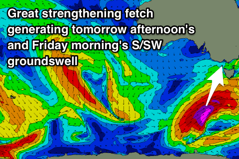
We're seeing a fetch of severe-gale to storm-force winds being generated in our southern swell window (satellite observations of 50kt fetch last night), with the low due to strengthen further while projecting north-east towards the Tasman Sea.
An elongated fetch of storm-force S/SW winds are expected, producing a large S/SW groundswell for tomorrow afternoon/evening, easing back through Friday.
Unfortunately an onshore change associated with the swell generating storm will move through tomorrow, with a dawn W'ly, swinging SW-S/SW mid-morning, spoiling the building swell.
The morning looks to be around 3ft+ on the Surf Coast and 5ft range to the east, kicking to 5-6ft and 6-8ft respectively through the late afternoon but with those onshore winds.
 The swell will ease back rapidly through Friday likely from 4-5ft on the Surf Coast down to 3ft through the late afternoon and 6ft+ range on the Mornington Peninsula along with lighter and more variable winds ahead of SE sea breezes.
Unfortunately the third low has fallen apart and will hardly generate any new swell at all over the weekend.
What we'll see is the swell continuing to drop steadily out of the S/SW leaving smaller easing 2ft+ waves on the Surf Coast Saturday morning, 3ft to maybe 4ft on the Mornington Peninsula with better N/NE winds.
Come Sunday the S/SW groundswell doesn't look to arrive until the afternoon, possibly kicking back to 2ft+ on the Surf Coast and 3ft+ on the Mornington Peninsula along with gusty N'ly winds.
Next week onwards (May 28 onwards)
As touched on last update, we'll see swells arriving more from the W/SW into next week as a strong node of the Long Wave Trough currently in the south-east Indian Ocean pushes east towards us while weakening.
On Monday a very acute long-period W'ly groundswell is due, produced by an intense low forming off the south-west tip of WA on Friday, directing a small tight fetch of severe-gale to storm-force W'ly winds in our western swell window.
The swell will be very west for the Surf Coast and only looks to offer 2ft+ waves on Monday, with better 4-5ft sets to the east though with a less than ideal N/NW tending NW breeze.
Stronger more distant storm energy south-west of WA will produce better aligned though inconsistent amounts of groundswell for Tuesday afternoon and Wednesday, mixed in with closer-range W/SW swells, but more on this Friday.