Plenty of swell and decent winds for the Surf Coast

Victoria Forecast by Craig Brokensha (issued Friday 18th May)
Best Days: Surf Coast most mornings and some days
Recap
Good clean waves on the Surf Coast all yesterday in the 3ft range, average to the west, while overnight a large long-period S/SW groundswell filled in, with clean easing 4-6ft sets on the Surf Coast this morning, larger and bumpy to the east.
Today’s Forecaster Notes are brought to you by Rip Curl
This weekend and next week (May 19 - 25)
These notes will be brief-ish as Ben’s away on holidays.
This morning's S/SW groundswell will ease through the day, backing off further from the 3ft range tomorrow morning on the Surf Coast and 4-5ft+ to the east.
Winds are looking better early, with a W/NW breeze for the Surf Coast favouring the reefs, shifting W/SW late morning.
A weak front pushing through our south swell window under Tassie today should produce a small S/SW swell for later tomorrow and Sunday morning but only to 2-3ft on the Surf Coast and 3-5ft to the east.
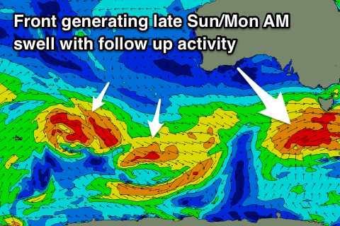 A stronger front pushing up on a similar track tomorrow will produce a better SW groundswell for Sunday afternoon, with sets due to reach 3-4ft late in the day on the Surf Coast with gusty W/NW tending W'ly winds.
This swell is due to peak Monday morning, mixed in with some mid-period energy in the mix from another front pushing up and into us.
We're looking at surf to 3-5ft on the Surf Coast and 6ft+ to the west along with gusty W/NW tending W/SW winds.
Moving into the rest of next week and we're due to see a flurry of strong polar fronts pushing up through our swell window and across Tassie under the influence of the Long Wave Trough sitting to our east over the Tasman Sea.
The next significant front will track south-east from the Indian Ocean, along the polar shelf while generating a fetch of W'ly gales.
This should generate a moderate sized SW groundswell for Wednesday, mixed in with some weaker mid-period energy from another localised front pushing through Tuesday evening and Wednesday.
We're likely to see wave heights ease back from 3-4ft on the Surf Coast Tuesday morning under a persistent W/NW breeze, while Wednesday sees wave heights kick back to 4-5ft into the afternoon though with a strong SW change. The morning will be cleaner and more around 3-4ft.
A mix of easing SW groundswell and new S/SW groundswell from another front are expected Thursday, and winds are due to tend more variable as a small high quickly moves in from the west.
It looks like we'll be on the tail end of the activity into the end of the week with a return to morning W/NW offshores Friday, but more on this Monday. Have a great weekend!
Comments
Quick question craig, is there a rough pattern on how often a node of the LWT will sit over vicco? if so, how often can one expect to see it. cheers
Nah there isn't sorry, each node and it's movement is unique.
hey Craig do you think there will be any swell at point leo on sunday by any chance
Only small and weak. Afternoon only.
okay cool thank you, do you reacon there will be any waves in morington tomorrow.
Mornington pier?