Good period for the Surf Coast with swells from more southerly angles

Victoria Forecast by Craig Brokensha (issued Wednesday 16th May)
Best Days: Thursday and Friday morning Surf Coast, possibly early Saturday Surf Coast, Sunday Surf Coast, next week Surf Coast
Recap
Clean small 2ft waves yesterday morning across the Surf Coast ahead of a mid-morning change, while today onshore S/SW winds have spoilt a good new mix of swells.
Today’s Forecaster Notes are brought to you by Rip Curl
This week and weekend (May 17 - 20)
These notes will be brief as Ben’s on holidays.
Today's good mix of swells (SW energy being the biggest and most dominant) will ease off through tomorrow but conditions will be good across the Surf Coast reefs most of the day with a persistent W/NW breeze. Easing sets from 3ft are due through the morning, while into the late afternoon some signs of new long-period S/SW groundswell should be seen.
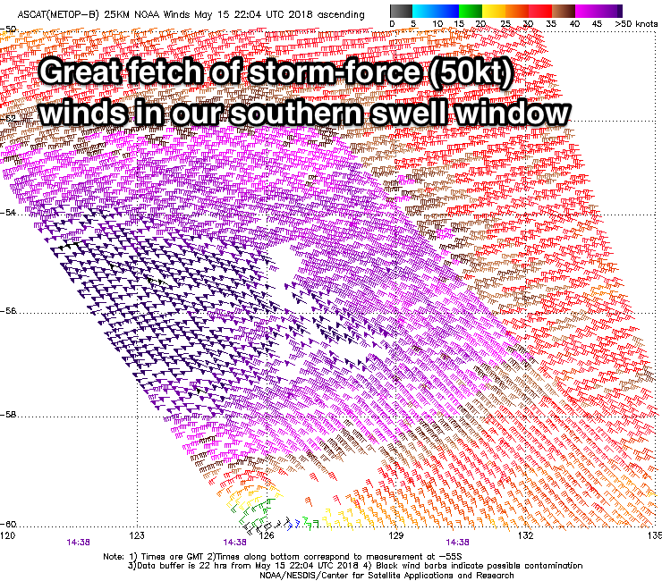 Satellite observations of the severe low linked to this swell are looking great with storm-force W'ly winds being generated in our southern swell window.
We'll see this low continuing to produce severe-gale to storm-force W/SW winds in our southern swell window this morning, before weakening slightly and passing under Tassie this evening.
The extra south in the swell direction and long-period nature will see large powerful waves across the Surf Coast Friday, with a peak due Thursday night, easing slowly thereafter.
Solid 5-6ft+ waves are due across the Surf Coast magnets early Friday with 8ft sets to the east, easing steadily through the day and a W/NW-W breeze is due to hold most of the morning, shifting SW into the afternoon.
With the large powerful nature of the swell, it will only be for experienced surfers.
Unfortunately the start of the weekend is still looking average, with Friday's onshore change linked to a strong slow moving high pushing in from the west, directing SW winds into all locations. There's a good chance for an early W'ly around Torquay, with easing 3ft to possibly 4ft sets on the reefs.
Sunday will be smaller and cleaner with a W/NW breeze holding all day and a fun S/SW groundswell to 3ft on the sets on the Surf Coast, generated by a weak and late forming polar front south-west of Tassie on Friday.
Next week onwards (May 21 onwards)
Into next week we're set to see a strong node of the Long Wave Trough stalling to our east, across the Tasman Sea and this will direct front after front up through our southern swell window, generating moderate to large pulses of S/SW groundswell and with generally favourable winds through the morning for the Surf Coast.
The first moderate sized swell is due to build Monday, easing Tuesday with a possible larger swell Thursday, but we'll have a closer look at this Friday.
Comments
Craig, but this is the best place I can think to post this question it as it relates to southern swell activity, the LWT (I think) and what happens after storms /swells pass Australia.
We often see swells coming through WA, and then up to Indo and across to Vic as the storm moves West-East.
In one of the Tahiti articles it mentioned that the swell aimed at Tahiti would continue on to the Eastern Pacific and light up the big wave spots around Chile and Peru. I think another comment mentioned that the storm for Tahiti sent some long energy to Vic on its way past (before really intensifying south of NZ)
If the LWT is pointing at Vic or WA and sending waves to Bells, will those storms (and/or swells) typically continue to move West-East and eventually light up spots like Chicama or Punta Lobos? If swells aimed at Vic don't make it that far, how far away do the swells for these places typically eventuate and are they related to LWT position near Australia?
Hey Leckiep,
No, if the LWT is aimed into WA or Vic the storms and swells will be focussed just east of where it is positioned (so south swells for Indo and stormy surf for WA in the former, and big swells for SA and west swells for Vicco on the later).
If the LWT is positioned east of New Zealand, depending on how amplified north/south it is, swells will either hit Tonga/Samoa and Tahiti onwards to Hawaii, but if angled more west/east then onwards to South America, Mexico etc. Better swells for Chile when the LWT is over in the south-east Pacific Ocean.
Awesome, this LWT stuff (and daydreaming about where swells end up) is fascinating.
Is there a place where the layman (ie me) can go and see the predicted location and angle of the LWT?
Can you see these..
http://www.weatherzone.com.au/models/?lt=hemisphere&lc=sh
Yes! Thanks - will have a look tonight.
Swell has just hit Cape Sorell, peak period at 21.9s.
yeah right!
Just looked then and was about too say ive never or cant rememebe Sorrell having a 20 sec on the graph.
How to distinguish forerunners and swell?
With the size kicking with the period, the two aren't that behind each other. This is also due to the storm being of close proximity to Vicco.
so if the storm is close, that would equal consistency? But then, how is the interval so big?
Because the storm was so strong with wind speeds about 45-50kts most of its lifespan.
Before a few sessions with Gary, the storm was much weaker. It even sent Gary a thank-you note for the training sessions.