Large W/SW swell for Sunday, easing slowly through next week

Victoria Forecast by Craig Brokensha (issued Friday 13th April)
Best Days: Surf Coast late Saturday, Surf Coast Sunday, Monday morning, Tuesday morning and early Wednesday
Recap
Average conditions through the morning across the Surf Coast, improving through the day with a mix of building W/SW groundswell and sneaky SE windswell, providing fun 2-3ft sets in protected spots. Early on the Mornington Peninsula conditions were clean, but the swell slow, bigger and messier into the afternoon.
The swell's on the ease today with good clean conditions across most spots and 2ft to occasionally 3ft waves on the Surf Coast, and improving 3-5ft sets on the Mornington Peninsula.
Today’s Forecaster Notes are brought to you by Rip Curl
This weekend and next week (Apr 14 - 20)
The weekend is still tricky, but the take home point is that Sunday will be the best of it.
 Tomorrow morning isn't looking worth travelling for, with today's swell due to drop further, while some new W'ly swell won't offer any real size on the Surf Coast until later in the day.
It'll likely be small to tiny through the morning and a strong NW wind will create clean conditions on the Surf Coast, poor to the east.
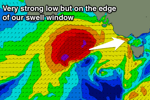
A very intense mid-latitude low is currently racing towards South Australia and once it starts pushing further east towards and across us, we'll see it dip south-east and broaden while slowly weakening.
This low is right on the edge of our swell window, and will generate W/SW gales right up into SA. If this system was positioned further south we'd see very large surf across Victoria into Sunday, but we're only due to really see size once it drops south-east and projects a fetch of W/SW gales through our western swell window Saturday afternoon and into Sunday morning
As the storm dips south-east Saturday afternoon a fetch of W/SW gales will be projected through Bass Strait, kicking up a strengthening W/SW windswell tending mid-period swell later in the day.
The Surf Coast should reach 4ft late in the day, but only building from mid-afternoon or so, with stormy 6ft+ surf developing on the Mornington Peninsula. Winds will remain strong and swing W/NW into the afternoon, only favouring protected breaks.
Come Sunday we should large levels of W/SW groundswell peaking through the morning to 5-6ft across exposed breaks, dropping slowly through the day, while the Mornington Peninsula looks to come in a large stormy 8-10ft.
If the mid-latitude low actually tracks a little further south than forecast, we can expect larger sets out across the Surf Coast through Sunday morning, but the one positive of this northern storm track will be favourable fresh to strong W/NW winds all day Sunday.
 Moving into Monday the swell will be a touch smaller but a much weaker mid-latitude front pushing in on the tail of the weekend's activity should generate some reinforcing W/SW groundswell for the afternoon Monday and Tuesday morning.
The Surf Coast should see easy 4-5ft waves into Monday morning and 6ft to occasionally 8ft waves on the Mornington Peninsula, as a fresh W/NW breeze, swings W/SW into the afternoon.
Tuesday still looks to hang around 4ft on the Surf Coast through the morning with winds generally offshore from the W/SW tending SW (early W/NW around Torquay).
Our final large SW groundswell for mid-week has been downgraded a little and will come in more from the S/SW.
The polar fetch of SW gales will form a little later and further east than forecast on Wednesday, but we'll still see a great fetch of SW-W/SW gales projected through our southern swell window.
A moderate sized S/SW groundswell should be generated, building through Wednesday, peaking overnight and easing Thursday.
Winds look OK early for the Surf Coast reefs Wednesday morning and from the W/NW, shifting S through the day, while Thursday looks average with S/SE winds.
Longer term we'll see the swell ease through the end of the week and next weekend under NE winds. More on this Monday. Have a great weekend!
Comments
whys it got tomorrow being 6ft+ now in the morning now tomorrow Craig are you still expecting 5-6 ft due to westerly swell direction
cheers
Dunno if it quite built to 4ft by late arvo Sat after all that wind & rain, also there's a drop of snow on Hotham & Falls - yew!
Still getting bigger on the ki buoy ..........Huge down there............en route to victoria...