Smaller weekend workable across both regions

Victoria Forecast by Craig Brokensha (issued Friday 6th April)
Best Days: Surf Coast Saturday morning, exposed beaches Sunday
Recap
Another pumping morning of waves across the Surf Coast yesterday with a reinforcing SW groundswell providing sets to 4-5ft at magnets, while to the east conditions were large and not ideal.
The swell eased through the day and this morning we're left with inconsistent 3ft sets on the Surf Coast with good conditions for the reefs again, and bumpy average waves to the east.
Today’s Forecaster Notes are brought to you by Rip Curl
This weekend and next week (Apr 7 - 13)
While the swell is on the ease from yesterday morning, we've got a new mid-period SW swell due tomorrow, produced by a weak but persistent polar front that's been moving through our swell window for a couple of days.
It'll be a day for swell magnets with 2ft to occasionally 3ft sets on the Surf Coast and 4ft+ waves on the Mornington Peninsula. Winds will be great for the Surf Coast with a very light NW offshore, while to the east we are expected to see a more variable breeze through the morning, but tending NW, favouring some breaks but not others.
Sunday will be much cleaner east of Melbourne under a fresh N/NE tending N breeze (N/NW on the Surf Coast) with small easing levels of SW swell from 2ft+ on the Surf Coast and 3ft to occasionally 4ft on the Mornington Peninsula.
Moving into early next week there's no new swell due with small tiny leftovers on the Surf Coast under a morning W/NW breeze, while more favourable NE winds are expected Tuesday morning but the exposed beaches will be lucky to come in over 2ft.
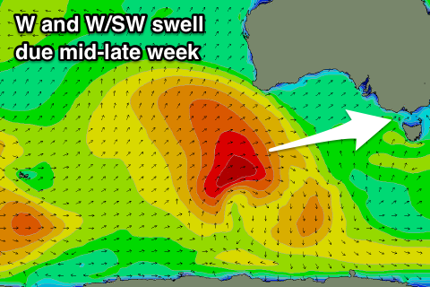 As touched on last update, our next swell will arrive from the W/SW, generated by a strong polar front projecting up towards WA over the weekend.
A fetch of W/SW gales will be initially projected through our western swell window, followed by a secondary better aligned fetch of gales in our west-southwest swell window, under the Bight early next week.
We'll see an inconsistent W'ly groundswell building Wednesday, with a better aligned W/SW groundswell Thursday.
Wednesday will remain tiny for most of the day ahead of a late kick at swell magnets to 2-3ft on the Surf Coast and 4-5ft on the Mornington Peninsula.
Winds are an issue though with a surface trough due to move through Wednesday resulting in a dawn W/NW'ly swinging onshore and fresh S/SE into the afternoon.
Thursday's winds are still unsure due to model divergence revolving around a mid-latitude low pushing in from the west, therefore we'll have to review this again on Monday.
Size wise the W/SW groundswell should come in at a better 3-4ft on the Surf Coast and 6ft on the Mornington Peninsula, but more on this Monday.
Have a great weekend!
Comments
barely a foot this morning at juc and super slow and fat on the lower tide
east of melb was on the pump...and topless bathers in the shorebreak i shit you not (: