Clean easing surf tomorrow, with a stormy increase in swell Monday

Victoria Forecast by Craig Brokensha (issued Friday 23rd March)
Best Days: Both coasts Saturday, Surf Coast Tuesday, early Wednesday exposed coasts, Surf Coast later Thursday and Friday onwards
Recap
A drop in swell with better though blowy conditions across the peninsula yesterday with sets easing from the 4-5ft range, while the Surf Coast saw a SE windswell in the mix to 3ft, best on the beaches.
This morning the swell is smaller and less consistent but much cleaner with 2ft+ waves on the Surf Coast and 3-4ft waves on the Mornington Peninsula.
Our new long-period SW groundswell is showing on all the buoys and we should see the surf build to an easy 3ft (if not for the odd bigger bomb) at magnets on the Surf Coast and 4-5ft on the Mornington Peninsula. Winds will go E/SE mid-afternoon though, so don't hold off too long into this afternoon for a surf.
Today’s Forecaster Notes are brought to you by Rip Curl
This weekend and next week (Mar 24 - 30)
This afternoon's increase in inconsistent long-period SW groundswell is due to ease through tomorrow from 2ft to occasionally 3ft across swell magnets on the Surf Coast early (not helped by the high tide) and the 4ft range on the Mornington Peninsula.
Local offshore winds should create great conditions through the morning, becoming variable into the afternoon.
Come Sunday the Surf Coast is expected to be small to tiny with the odd stray 1-2ft set under fresh NW tending stronger W/NW winds.
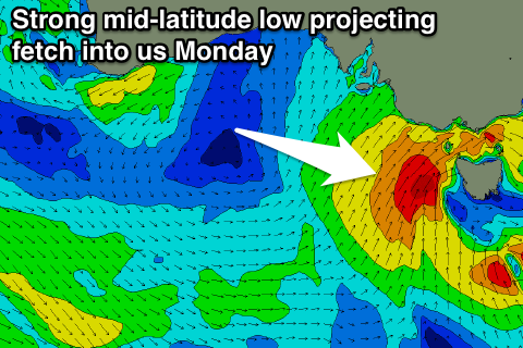 This strengthening west-northwest breeze will be linked to a deepening mid-latitude low approaching from the west.
On Sunday a fetch of gale to severe-gale W'ly winds will be aimed initially too north of our western swell window, but as we move into Monday we'll see the fetch pushing through Bass Strait as the low moves east across us.
A fetch of W/SW tending S/SW gales will be aimed into us, kicking up a stormy increase in swell through the day to 4-6ft on the Surf Coast and 6ft+ on the Mornington Peninsula.
Winds will be strong from the W/NW through the morning, favouring the Surf Coast reefs early, though the swell will be windswelly and weak, probably without much size over 3ft either. A strong SW change will then move through mid-morning creating poor conditions for the rest of the day as the swell builds.
We'll see a strong high move in from the west on Tuesday and this will swing winds back around to the N/NW creating great conditions across the Surf Coast as the swell eases quickly.
We may see 3-4ft sets at dawn across magnet, down quickly into the afternoon and back to a smaller leftover 2ft max on the sets Wednesday morning. The Mornington Peninsula should ease from 4-6ft Tuesday morning, back to 3ft to maybe 4ft Wednesday morning.
Winds early Wednesday look good for both regions with a straight N'ly, but a weak mid-latitude trough clipping the state will bring an afternoon W'ly change though no new swell.
A broader and slightly stronger mid-latitude front pushing from under WA through the Bight on Tuesday next week should produce a new mid-period W/SW swell for Thursday afternoon, building from a small 1-2ft on the Surf Coast and 3ft+ on the Mornington Peninsula more towards 2-3ft and 4-5ft respectively late in the day.
Fresh NW tending W/NW winds will favour the Surf Coast and a late surf would be the pick across protected spots.
Of greater importance is stronger frontal activity due behind this first mid-latitude frontal system, owing to a broad strong node of the Long Wave Trough moving slowly in from the west later next week.
A broad and elongated fetch of strong W/SW winds should form through our swell window under the country later week, with stronger embedded fronts projecting gales towards us.
This should generate further pulses of W/SW and SW groundswell into Friday afternoon and the weekend, but the specifics behind this are still unsure.
Friday morning we're likely to see surf to 3ft to possibly 4ft on the Surf Coast magnets and 6ft range to the east, with more size later in the day/Saturday with winds from the western quadrant. More on this Monday. Have a great weekend!
Comments
How many Gary’s tomorrow morning on the ninch Craigs?
Jokes.Appreciate the forecasts greatly!
youll be smoking
2ft slop with howling onshore till 10 all morning on the reefs
Yeah can't predict local thunderstorms unfortunately.
whys the forecast saying 6ft+ for tomorrow yet in your comments youve got maximum of 3-4ft?????
Monday we'll see the fetch pushing through Bass Strait as the low moves east across us.
A fetch of W/SW tending S/SW gales will be aimed into us, kicking up a stormy increase in swell through the day to 4-6ft on the Surf Coast and 6ft+ on the Mornington Peninsula.
:)
Snap.
It actually reads 4-6ft in the notes above, and the position of the dynamic low is now more in Vicco's swell window, so you can now expect larger surf to develop through the day but with strong winds.
They need to move the comp site for next Tues Wed. If all the planets align could be seriously sizey with light onshore winds . change of venue .