Strong clean swells Saturday, easing Sunday with poor surf early next week

Victoria Forecast by Craig Brokensha (issued Friday 16th February)
Best Days: Surf Coast Saturday morning, both regions Sunday morning, east of Melbourne Tuesday morning and Wednesday morning
Recap
Pumping waves across the Surf Coast yesterday and this morning with strong levels of W/SW swell to 4-5ft, with larger messier waves on the Mornington Peninsula.
Back to back mid-latitude fronts generated this swell and we'll see the surf starting to ease through this afternoon with average winds.
Today’s Forecaster Notes are brought to you by Rip Curl
This weekend and next week (Feb 17 – 23)
In the wake of the strong mid-latitude frontal activity through our western swell window, we've now got a stalling and strong low directly south-west and south of us.
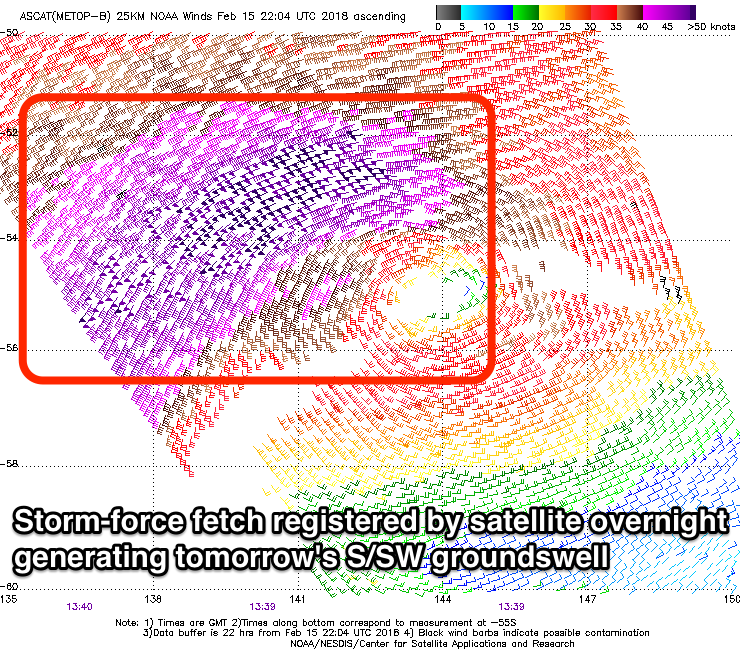 Last night a good fetch of strong to gale-force W/SW winds were persisting in our south-western swell window, with stronger severe-gale to storm-force SW winds in our southern swell window.
We're due to see these winds persist this morning while starting to move north-east, out of our swell window this afternoon.
We can expect moderate amounts of SW groundswell to persist tomorrow, with a new stronger S/SW groundswell from the storm-force winds, providing solid 4-5ft sets most of the day on the Surf Coast and 6ft+ waves on the Mornington Peninsula.
Winds are looking great for the Surf Coast and light offshore from the NW, tending W/NW ahead of possible sea breezes and then a fresher mid-afternoon SW change. Locations east of Melbourne may see lighter N winds at dawn before swinging more NW.
Into Sunday both the SW and S/SW energy will ease likely from the 3ft+ range on the Surf Coast and 4-5ft+ on the Mornington Peninsula as winds tend more variable. This should create favourable conditions for most spots ahead a S/SE change associated with a surface trough moving in from the west.
This trough will be the catalyst for a poor run of winds into early next week as it stalls off the southern NSW coast and strengthens while a strong high moves in from the west.
As a result moderate to fresh SE winds will strengthen from the E/SE on Monday, creating poor conditions and a building SE windswell on the Surf Coast, mixed in with a new S/SW groundswell.
The groundswell will be produced today and tomorrow by a final polar front firing up on the backside of the low to our south, projecting a good fetch of strong to gale-force SW winds through our southern swell window.
The Surf Coast should see 3-4ft sets, with 6ft surf on the Mornington Peninsula, but with those poor winds.
Winds will swing a little more east into Tuesday but remain gusty with a poor mix of easing S/SW swell and SE windswell on the Surf Coast and peaky workable waves in protected spots east of Melbourne, likely easing from 3-4ft.
Much cleaner conditions should be seen Wednesday with a NE wind, but with no new swell even the beaches east of Melbourne will be small. Longer term we may see some new W/SW swell late week but with onshore winds. More on this Monday. Have a great weekend!
Comments
Lorne still offering some tidy waves for the early session.
