Light at the end of the tunnel

Victoria Forecast by Craig Brokensha (issued Friday 9th February)
Best Days: Both coasts Saturday morning for keen surfers, Surf Coast Monday morning for keen surfers again, Tuesday morning, Wednesday morning
Recap
The swell bottomed out yesterday morning with varying winds across the state, while today some new W'ly swell has filled in. Most spots were still bumpy though with tiny surf around Torquay, 1-2ft waves at 13th Beach and 3ft sets to the east.
Today’s Forecaster Notes are brought to you by Rip Curl
This weekend and next week (Feb 10 – 16)
Tomorrow morning will be the pick of the weekend, with today's W'ly swell due to fade, replaced by a small background SW swell. Surf Coast swell magnets should see 2ft waves with 3-4ft sets on the Mornington Peninsula, masked a little by the morning high tide. It'll show better late morning as the tide drops.
Winds should be favourable for most breaks in the morning with local offshore N'ly winds, tending more NW into the afternoon ahead of a W/SW change.
This change will unfortunately bring fresh SW winds into Sunday with no real decent increase in swell.
The small strengthening fetch of W/SW gales expected late in our swell window on Sunday by both models has now been wiped, with only a weak increase in mid-period W/SW swell and SW windswell due Sunday afternoon.
The Surf Coast isn't likely to see much size above 2ft and 3-4ft on the Mornington Peninsula, easing Monday with a morning W/NW across the Surf Coast, SW into the afternoon.
Of greater importance is the better swell energy due through the week, with a flurry of strong frontal activity through the Southern Ocean owing to a strong node of the Long Wave Trough strengthening through the Bight and moving east.
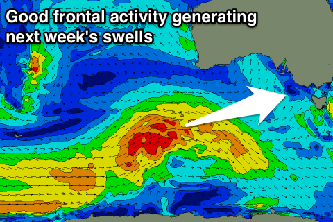 Currently we've seen a small strong polar low form south of Heard Island, with this system due to project east-northeast towards the Bight through today and the weekend, weakening south-west of us Sunday.
Wind speeds will initially be gale to severe-gale-force, weakening as the front gets closer.
Long-period less consistent swell energy will be generated for Wednesday morning, but through Tuesday mid-period energy will be seen arriving ahead of this, due to the front racing ahead of itself.
We should see building surf from the 2ft+ range on the Surf Coast Tuesday morning, to 3ft+ later in the day, with the Mornington Peninsula increasing to 4-6ft, with the groundswell for Wednesday morning coming in at a less consistent 3-4ft and 5-6ft respectively.
During the day though we'll another more consistent mid-period W/SW swell filling in, generated by a mid-latitude front pushing in from under WA and through the Bight and across us next week.
This will just provide more consistent surf in the size listed above. There's further activity possible, but the models are still moving around so we'll take a closer look at this Monday.
Winds are looking variable Tuesday morning N/NW tending W winds Wednesday, but more on this Monday. Have a great weekend!