OK waves Friday and early Saturday, more swell from Sunday afternoon

Victoria Forecast by Craig Brokensha (issued Wednesday 7th February)
Best Days: East of Melbourne Friday morning, exposed spots both coasts Saturday morning, Surf Coast Monday morning
Recap
A drop in swell across the Mornington Peninsula yesterday to 2ft+ with bumpy conditions, while the Surf Coast saw a SE windswell to 1-2ft with similar average conditions.
This morning was a touch smaller again but cleaner across all locations with more variable winds.
Today’s Forecaster Notes are brought to you by Rip Curl
This week and weekend (Feb 8 – 11)
Moving into tomorrow we'll see the swell bottom out completely across the Victorian coast with hardly a wave to be ridden. Conditions should be clean with variable tending locally offshore winds before sea breezes kick in.
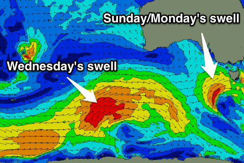
Our new W'ly swell due into Friday is on track, with an intense low south-west of WA generating a fetch of W'ly gales in our western swell window.
This swell has come in well across WA today and should fill in Friday across the Victorian coast.
The W'ly direction will not favour the Surf Coast at all with tiny waves expected in Torquay, with the possibility of 2ft sets at 13th Beach through the day.
 The Mornington Peninsula should see fun 3ft surf, with the odd 4ft set in the mix at the swells peak.
Winds will be favourable for the beaches with a variable breeze from the E during the morning ahead of afternoon sea breezes.
The swell is expected to ease into Saturday, with some small reinforcing SW energy due from a weak polar fetch of W/SW winds trailing the low.
The Surf Coast isn't due to offer much more than 2ft sets at swell magnets, with 3-4ft waves on the Mornington Peninsula and winds look favourable early, from the N'th ahead of a shift to the W/NW through the day and late W/SW change.
This change will be linked to a mid-latitude front pushing in from the west later this week, generating a fetch of strong W/SW winds projected towards us, reaching the gale-force range late in our swell window as the system approaches Tasmania.
We should see a small to moderate sized W/SW tending SW swell from this front, building Sunday afternoon, peaking overnight and easing Monday.
The Surf Coast is expected to reach 3ft into the afternoon with 4-5ft sets on the Mornington Peninsula, easing from a similar size Monday morning.
Winds look onshore Sunday though and from the SW, while Monday looks to see morning W/NW breezes, favouring the Surf Coast.
Longer term the outlook is better, with the weekend's front just the start of some stronger and better frontal activity through the Southern Ocean. We're looking at a moderate to large swell through the middle of next week though winds could be an issue. More on this Friday.