Lots of swell to come with winds swinging a full 360

Victoria Forecast by Craig Brokensha (issued Monday 8th January)
Best Days: Surf Coast early Tuesday, beaches Thursday morning, most locations Friday ahead of the change, Surf Coast Saturday morning
Recap
Fun waves across both regions Saturday morning, best on the exposed beaches with clean easing 3-4ft sets, 2ft on the Surf Coast.
Sunday was poor with a small to tiny leftover swell and onshore wind, but some decent windswell was seen later in the day, though quality wasn't ideal.
This morning we've seen stronger levels of groundswell fill in with a bit more size than forecast on Friday coming in at 3ft across most breaks on the Surf Coast (4ft sets 13th Beach) though with average conditions and workable 4-5ft surf across the Mornington Peninsula.
Today’s Forecaster Notes are brought to you by Rip Curl
This week and weekend (Jan 9 - 14)
This morning's spike in W/SW groundswell is has peaked, and we'll see it drop slowly through the day, bottoming out early tomorrow ahead of a reinforcing increase for the afternoon.
This swell will be less consistent, generated further away and south-west of WA on Saturday.
The Surf Coast should hold around 2ft+ (2-3ft 13th Beach) in the morning with 4ft+ surf on the Mornington Peninsula, increasing back to more the 3ft range on the sets across most of the Surf Coast and 4-5ft on the Mornington Peninsula.
 Winds however will be an issue with an early W/NW'ly expected to give into a gusty SW change mid-morning.
The swell should hang in at a similar size Wednesday morning as another W/SW groundswell fills in before easing slowly through the day, but conditions will remain poor with a moderate to fresh SE breeze.
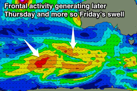
Another temporary low point in swell is due Thursday morning ahead of slight increase in new W/SW groundswell for the afternoon but more so Friday generated by the final flurry of frontal activity through our swell window south of WA.
Thursday morning we'll be looking at surf continuing to 2ft+ across the Surf Coast (2-3ft 13th Beach) and around 4ft+ on the Mornington Peninsula, increasing slightly through the afternoon with an E/NE tending NE breeze ahead of SE sea breezes.
Friday should offer more size to in the 3ft range on the Surf Coast and 4-5ft+ on the Mornington Peninsula with great N/NE winds, strengthening ahead of a gusty W/SW change mid-late afternoon as a deepening surface trough drifts south-east across us.
This trough will aim a very short-lived fetch of W/SW gales in our western swell window, producing a small pulse of W/SW swell for Saturday but this looks to be below Friday's size at this stage.
Another strong front approaching from the west will swing winds NW though for Saturday before pushing through the afternoon, bringing with it a solid increase in W/SW swell Sunday though with onshore SW winds. We'll review this Wednesday though.
Longer term we've got quite an interesting long-period and long-range W/SW groundswell due through next week, generated as a tropical cyclone off Madagascar is absorbed into the westerly storm track, but more on this Wednesday.