Fun waves across the exposed beaches tomorrow morning

Victoria Forecast by Craig Brokensha (issued Friday 5th January)
Best Days: Exposed breaks tomorrow morning, Surf Coast early Tuesday, beaches to the east Wednesday and Thursday mornings
Recap
Wednesday afternoon's kick in reinforcing SW swell held well into yesterday morning with 3-4ft sets across magnets on the Surf Coast with offshore winds, bigger to the east but not ideal.
Today the swell was back to 2-3ft on the Surf Coast and 3-5ft on the Mornington Peninsula with more variable winds, and we should see a reinforcing SW swell mid-late morning keeping the surf around a similar size all day.
Today’s Forecaster Notes are brought to you by Rip Curl
This weekend and next week (Jan 6 - 12)
The pulse of reinforcing SW groundswell due through today is expected to ease back through tomorrow from a fun 2ft on the Surf Coast and 3-4ft on the Mornington Peninsula.
Conditions will be ideal for exposed beaches during the morning with a fresh N/NE'ly, swinging more NW into the afternoon ahead of a late W/SW change.
 This change will linger into Sunday morning as the swell bottoms out, creating poor surfing conditions.
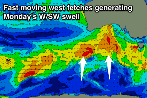
Our W/SW windswell from the front due into the afternoon doesn't look to be significant at all, but a better W/SW groundswell is due into Monday.
This will be generated by an initial fetch of strong to gale-force W/SW winds being projected through our western swell window tomorrow morning, followed by a secondary stronger and better aligned fetch under WA through the afternoon.
We should see the Surf Coast coming in at 2-3ft on Monday (consistent 3ft at magnets) with 4-5ft+ waves on the Mornington Peninsula, though SE winds unfortunately look to create average conditions across most locations.
A temporary drop in swell is expected Tuesday morning as winds revert back to the W/NW early with a weak approaching front.
This will favour the Surf Coast but it'll only be around 2ft+.
Through the afternoon we'll see some long-range W/SW groundswell fill in, produced by a more distant polar front generating a fetch of strong to gale-force W/SW winds south-west of WA tomorrow.
This should pulse the Surf Coast back to 2-3ft, with 4-5ft sets on the Mornington Peninsula though with winds swinging S/SE on the back of the morning W/NW breeze.
The swell is expected to slowly ease Wednesday as winds swing back to the E.
Longer term, persistent weak frontal activity through the Southern Ocean should maintain small fun waves late week as winds swing more NE Thursday and then back to the W/NW Friday with an approaching front. We'll nail this down further on Monday. Have a great weekend!
Comments
Nice waves this AM.


Couple of feet off on the M P report today.
It’s an inconsistent 3-4 ft.
Not a strong 4-5ft as noted on the report
Water temp is deluxe at the moment tho!
Swell is dropping like a rocket at the Cape Sorell buoy.. expect the same trend across Vicco beaches during the day.
Woolamai looking very nice too.


https://www.swellnet.com/surfcams/woolamai
Lorne picking up late lines of new swell. Not a soul in the water!

That looks fun
Plenty of swell right on dark in Torquay too.
