Great run for the Surf Coast

Victoria Forecast by Craig Brokensha (issued Friday 29th December)
Best Days: Surf Coast Saturday, Sunday, Monday, Tuesday morning, possibly early Wednesday
Recap
Tiny clean waves across the Surf Coast yesterday morning, better on the exposed beaches to the east with infrequent sets to 2ft or so.
Today a small inconsistent W/SW swell has filled in providing 1-1.5ft waves across the Surf Coast and 2-3ft sets to the east though with early weak onshore winds which has since tended more variable.
Today’s Forecaster Notes are brought to you by Rip Curl
This weekend and next week (Dec 30 – Jan 5)
We've got a good run of swell on the cards from tomorrow, with favourable winds for the Surf Coast.
Firstly tomorrow morning, our secondary pulse of W/SW groundswell from mid-latitude frontal activity south-west of WA should fill in.
There's been no change to the expected size, with 2ft+ waves due on the Surf Coast (3ft sets at 13th Beach) and 4-5ft waves on the Mornington Peninsula.
This swell will however be overridden by our third pulse of W/SW groundswell into the afternoon and evening.
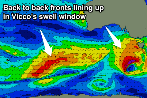 The stronger mid-latitude front linked to this swell is currently pushing east, south of the Bight, producing strong to near gale-force W/SW winds.
This front will continue east through our swell window today and push through Bass Strait tomorrow morning.
What we'll see is an initial increase in weak W/SW windswell, with a stronger pulse of groundswell late afternoon and into the evening.
With this, we should see the Surf Coast reaching 3-4ft with 6ft+ sets on the Mornington Peninsula.
Winds will be best for the Surf Coast with a gusty morning W/NW breeze, tending W/SW late morning/midday.
Sunday morning should still provide plenty of size across both coasts with 3ft to occasionally 4ft sets at magnets early and 5-6ft waves on the Mornington Peninsula as a W/NW breeze favours the Surf Coast. Winds should remain good until early-mid afternoon.
As we move into Monday another good pulse of reinforcing W/SW swell is due, produced by a broad pre-frontal fetch of W/NW winds moving under the country tomorrow and Sunday.
The swell should fill in Monday and peak through the afternoon, boosting the Surf Coast back to 3ft+ with 5-6ft waves on the Mornington Peninsula.
The Surf Coast will again be the pick with a morning W/NW breeze, swinging SW into the afternoon.
A slow drop in size is expected from Tuesday, though some weaker trailing frontal activity will continue to produce small to moderate amounts of mid-period energy Wednesday/Thursday.
Winds look as if they'll continue to be favourable for the Surf Coast Tuesday morning, but Wednesday and Thursday look to see more onshore S'ly breezes. More on this Monday. Have a great weekend and Happy New Year!