Improving conditions for the beaches, new swell from Friday

Victoria Forecast by Craig Brokensha (issued Monday 11th December)
Best Days: Both coasts Tuesday, exposed beaches Wednesday morning, Surf Coast from Friday afternoon
Recap
A fun weekend on the Surf Coast with small clean waves to start on Saturday, building through the afternoon with a new SW swell and peaking yesterday to 3-4ft at swell magnets, with larger bumpier waves on the Mornington Peninsula.
Today a reinforcing swell has kept the swell up around a super fun size with clean conditions again, lumpy and to 4-6ft on the Mornington Peninsula.
Today’s Forecaster Notes are brought to you by Rip Curl
This week and weekend (Dec 12 – 17)
The weekend's swell was generated by a strong polar frontal system strengthening directly south-west of us, followed by a secondary front, generating a reinforcing swell for today.
This swell should ease back through tomorrow from 2-3ft on the Surf Coast and 4-5ft on the Mornington Peninsula with cleaner conditions due across the beaches.
This will be a result of a light variable wind during the morning (tending locally offshore at some spots) but likely a little lumpy out on the exposed beaches early, improving through the mid-late morning ahead of sea breezes.
Wednesday morning will be straighter with a N/NE breeze (tending lighter N/NW into the afternoon) but small and easing from 3ft on the sets on the Mornington Peninsula. The Surf Coast should be clean but fading from an inconsistent 1-2ft at magnets.
 Westerly winds and a tiny swell will leave no real options for a surf on Thursday while as talked about the last couple of updates, we're due to see some good new W/SW and SW groundswell building Friday and persisting all weekend.
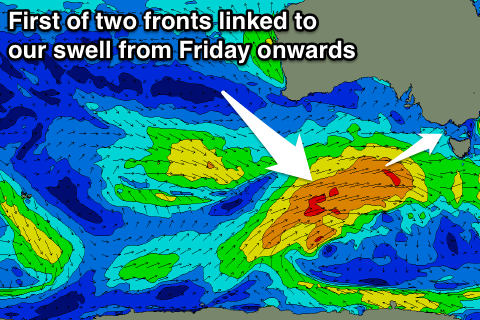
These swells will be produced by a good frontal progression that's currently south-west of WA, strengthening while slowly moving east through this week.
Distant W/SW energy is due from the current storm, but more consistent and a bigger SW swell should be produced as a good fetch of strong to near gale-force W/SW winds develop south of the Bight mid-late week.
A secondary fetch of strong W/SW winds projecting closer to us Friday and Saturday will then produce a reinforcing SW swell.
The first swell should build Friday and peak late afternoon/early evening to 3-4ft at magnets on the Surf Coast and 5-6ft on the Mornington Peninsula, dropping slightly through Saturday ahead of a reinforcing pulse Sunday morning to 3ft and 4-6ft respectively. EC is showing a stronger secondary system producing much larger waves Sunday, but we'll have an update on this Wednesday.
Looking at the winds and an onshore SW'ly is expected as the swell builds Friday, with offshore W/NW winds Saturday morning, swinging SW early-mid afternoon.
Sunday is still a little unsure to the possible secondary strong swell, so check back Wednesday.
Comments
:)