Improved outlook for the weekend

Victoria Forecast by Craig Brokensha (issued Friday 8th December)
Best Days: Surf Coast keen surfers Saturday afternoon, Surf Coast Sunday, Surf Coast Monday, both regions Tuesday and exposed beaches Wednesday morning
Recap
Cleaner conditions across the Surf Coast yesterday with lighter winds but a small to tiny leftover swell to 1-1.5ft+ while the Mornington Peninsula was a bumpy 2-3ft.
This morning some new W/SW windswell and mid-period energy was on the build with small weak 2ft sets on the Surf Coast with a W'ly wind and poor conditions to the east.
We should see magnets on the Surf Coast hitting 2-3ft this afternoon though with onshore W/SW winds.
Today’s Forecaster Notes are brought to you by Rip Curl
This weekend and next week (Dec 9 – 15)
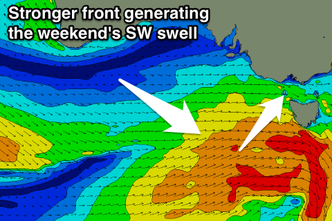
The front generating the weekend's swell is now looking a little stronger and in line with Monday's forecast which is a plus.
We'll see a relatively weak front that's currently south of the Bight strengthening through today in our south-western swell window, with a broad fetch of strong to near gale-force W/SW winds developing.
This will generate a building and strengthening SW groundswell through tomorrow, likely rising from 2ft early on the Surf Coast and hitting 3ft late in the day. The Mornington Peninsula should increase from 3-5ft more towards 6ft later.
 A morning W/NW wind will favour the Surf Coast as the swell builds, but the afternoon will be bumpy as winds tend W/SW.
A peak in swell is expected overnight/early Sunday and we should see 3ft+ sets across swell magnets on the Surf Coast and 6ft on the Mornington Peninsula. A light morning W/NW wind will favour the Surf Coast again, tending onshore into the afternoon.
Our reinforcing swell for Monday is still on track, with a secondary weaker front generating a pre-frontal fetch of W/NW winds through Saturday evening and Sunday.
This should keep 3ft sets hitting the Surf Coast through Monday, with 4-6ft waves on the Mornington Peninsula along with W/NW tending S/SW winds.
Tuesday and Wednesday look great for the beaches as the swell starts to ease back from 2-3ft at magnets on the Surf Coast and 4-5ft on the Mornington Peninsula with a variable N/NE breeze ahead of sea breezes Tuesday and then N/NE winds Wednesday.
Longer term there's no new swell expected until late week/next weekend when we may see a fun W/SW groundswell, but more on this Monday. Have a great weekend!
Comments
Plenty of lines at Torquay this morning, though the dawn high tide is still causing a few problems.
