OK waves over the coming period

Victoria Forecast by Craig Brokensha (issued Wednesday 8th November)
Best Days: Keen surfers tomorrow morning, beaches east of Melbourne Friday, Saturday, Sunday and Monday mornings
Recap
Poor conditions continued across both regions yesterday with a messy onshore windswell through the morning ahead of a stronger spike in new S/SW groundswell later in the day.
This swell peaked overnight but offered good 3-4ft sets on the Surf Coast this morning and sets to 6ft on the Mornington Peninsula along with weaker onshore breezes.
This week and weekend (Nov 9 - 12)
This morning's S/SW groundswell will continue to ease into tomorrow from 2ft+ on the Surf Coast and 4ft on the sets across the Mornington Peninsula and conditions will improve but likely remain lumpy and wobbly with an early variable wind.
SE breezes will develop through the mid-late morning, so the window of decent conditions will be small.
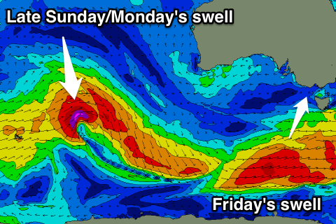
Our new S/SW groundswell for Friday is still on track, with a strong polar front to our south-west due to move through our swell window today.
 We should see good surf to 3ft on the Surf Coast Friday with 4-5ft sets on the Mornington Peninsula (if not for the odd bigger bomb into the afternoon across both coasts), but a morning E'ly breeze will only favour the beaches east of Melbourne, tending SE into the afternoon.
The swell will ease back through Saturday from a similar if not slightly smaller size range and winds will play out similar, E in the morning and onshore into the afternoon.
A low point in swell activity is expected Sunday morning as E'ly winds persist. These E'ly winds will kick up some junky windswell for the Surf Coast but to no major size. A small long-period W/SW groundswell is also due into Sunday afternoon, generated by a distant low between Heard Island and Western Australia, with no major size due across either coast.
The Surf Coast may see 2ft sets, with 3-4ft waves on the Mornington Peninsula late in the day and Monday morning.
Winds should start to swing more NE with an approaching trough on Monday, creating cleaner conditions across the exposed beaches.
Longer term there's still nothing major on the cards for next week until Thursday/Friday, but we'll have another look at this Friday.
Comments
I think i may vaguely remember a article about what role winds play in moving sand (or dont)??
Yeah it was mentioned in the Skeleton Bay article. More so strong persistent winds over months/years.
Dislocated skeleton: The shifting position of Skeleton Bay
those winds: EEEEEEEEEEEEEEEEEEEEEEEEEEEEEEEE!