Fun surf Sunday, large swell building Monday afternoon, easing Tuesday

Victoria Forecast by Craig Brokensha (issued Friday 27th October)
Best Days: Both coasts Sunday, Surf Coast Monday, protected locations early Tuesday, Surf Coast Wednesday morning
Recap
Wednesday afternoon's swell hung in yesterday morning across all locations but a fresh S'ly wind created average conditions, only for the most keen of surfers.
This morning the surf was much cleaner across the state but the swell tiny and full on the Surf Coast early and only 2ft+ on the Mornington Peninsula. The dropping tide should provide some small options for desperate surfers mid-late morning.
This weekend and next week (Oct 28 – Nov 3)
This morning's small waves are on the way out and we'll be left with effectively flat conditions across all locations tomorrow with a morning W/NW breeze.
Into Sunday our new W/SW swell is still on track, but the timing and size have changed a little.
This swell will be produced by a strong mid-latitude front that's currently passing under the south of WA.
 This front will produce a fetch of strong to gale-force W/SW winds just within our western swell window, pushing east closer towards us this evening before dipping south-east tomorrow.
The strength of the front is a touch weaker than forecast on Wednesday but the arrival time has been pushed forward to the morning.
With the west in the swell, protected breaks on the Surf Coast will be quite small, but exposed breaks like 13th Beach should see 2-3ft waves, while the Mornington Peninsula is due to come in around 4-5ft+.
Winds are actually looking good for both regions early Sunday with a morning N'ly breeze, freshening and then tending N/NW into the afternoon. This should provide fun waves all day at exposed breaks.
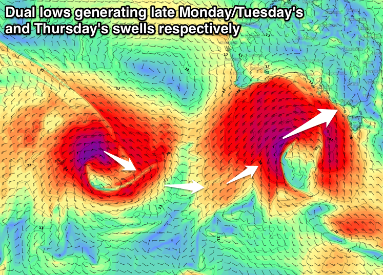
Moving onto the larger swell event due into early next week, and over the past few days the structure, strength and positioning of the vigorous low have changed, sometimes for the better and other times for the worse.
What we've got this morning is somewhere in between, with the low due to sit in our swell window for most of its lifespan, but with a slight downgrade in its initial intensity.
The storm will form south-west of WA this evening, with a great fetch of severe-gale W'ly winds moving in on top of the active sea state generated by the front currently passing under WA.
We'll then see the low broaden, with a greater area of severe-gale W/SW winds generated as it approaches the Bight. Into tomorrow evening core wind speeds are due to reach the storm-force range as the low stalls slightly in our swell window. This will be favourable for generating larger surf than if the low continued east, and we'll then see the storm dissipate into early Monday.
A large long-period W/SW groundswell will be produced by this low, arriving mid-late morning Monday and building strongly through the afternoon, peaking overnight and easing Tuesday.
It's hard to tell how much size we'll see Monday morning before the groundswell proper fills in, but it's likely to be in the vicinity of 3ft+ across the Surf Coast and 6ft on the Mornington Peninsula. The groundswell should build to the 6ft range by late in the day on the Surf Coast and 8-10ft on the Mornington Peninsula, easing back from a similar size Tuesday morning.
Winds on Monday will be great for the Surf Coast reefs until early-mid afternoon with a fresh and gusty W/NW'ly, swinging W/SW thereafter.
Tuesday looks a bit dicey with onshore W/SW-SW winds everywhere besides the Torquay region which will see a short-period of early W/NW winds.
The swell will drop further into Wednesday but steady in the 3ft+ range across the Surf Coast and 6ft on the Mornington Peninsula ahead of a new long-period SW groundswell for Thursday.
This will be generated by a secondary strong low forming behind the storm over the weekend, but further south in position.
We'll see a great fetch of severe-gale to storm-force W'ly winds produced through our far swell window south-west of WA before the low slowly weakens while moving closer to the polar shelf and us.
The prolonged nature of this low and strong winds will result in a moderate to large SW groundswell, with a peak due through the morning Thursday, easing slowly Friday.
The Surf Coast should see 4-5ft+ waves across magnets Thursday morning with 8ft sets on the Mornington Peninsula.
Looking at the expected winds, and Wednesday looks to play out similar to Tuesday with an early W/NW breeze on the Surf Coast, W/SW-SW elsewhere, while Thursday unfortunately looks average at this stage as a ridge moving in from the west and polar front approaching from the south-southwest result in S/SW winds. We'll have a closer look at this Monday. Have a great weekend!
Comments
Paging Vic Local!
Prediction for next weeks swell? Or just come on late next week writing off Craig and Co for the forecast not being exact?