Slow couple of days, large for the weekend

Victoria Forecast by Craig Brokensha (issued Monday 25th September)
Best Days: Both coasts later Wednesday, Surf Coast Thursday morning, Friday morning, Saturday morning, Sunday morning and early next week
Recap
A drop in swell from Friday with small clean waves on the Surf Coast Saturday though without any major energy, while the beaches to the east offered the best waves.
Yesterday was a touch smaller and freshening NW winds only favoured the Surf Coast. This freshening NW'ly was linked to a mid-latitude pushing across us and this generated a small weak W/SW swell which has come in at 2ft on the Surf Coast 3-4ft on the Mornington Peninsula with early W/NW winds around Toquay.
This swell will ease through the day as winds swing onshore.
This week and weekend (Sep 26 – Oct 1)
Tomorrow isn't looking too good at all with the swell becoming small to tiny along with a light morning W/NW breeze. A variable wind is due through the middle of the day before SE sea breezes kick in.
Wednesday will start out tiny under fresh E/NE-NE winds, tending N/NW mid-late afternoon as a new S/SW groundswell arrives.
 This swell is being generated by a strong polar front to our south-southwest, strengthening late in our swell window.
We should see the Surf Coast kick to 2ft+ later in the day with 4ft sets on the Mornington Peninsula. This swell is expected to ease back through Thursday with small 2ft waves left on the Surf Coast and 3-4ft sets on the Mornington Peninsula with a fresh W/NW tending W/SW breeze as a cold front pushes across us.
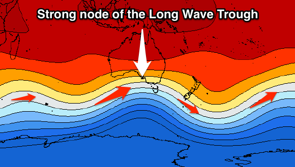
This front will be quite weak, and the precursor to a much more significant cold-outbreak behind it, mentioned the last few updates. This strong polar frontal progression will be linked to a strong node of the Long Wave Trough strengthening over the Bight and the south-east of the country later this week.
 The first frontal system should generate some good new mid-period SW swell for Friday, coming in around 3ft on the Surf Coast and 4-5ft on the Mornington Peninsula along with NW tending W/NW breezes.
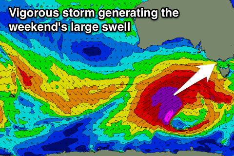
The secondary polar front will project a fetch of severe-gale to storm-force W/SW tending SW winds through out south-western swell window before projecting up and into us Friday afternoon and evening.
What we'll see is some large consistent close-range W/SW swell generated by the strong front pushing into us Friday, filling in Saturday and coming in around 5-6ft+ on the Surf Coast and 8ft+ on the Mornington Peninsula.
The long-period groundswell may be seen later in the day, but a peak is due early Sunday with large 6ft+ sets on the Surf Coast and 8ft+ waves continuing on the Mornington Peninsula, easing slowly through the day.
Another approaching front will steer winds around to the W/NW Saturday morning, likely tending W-W/SW through the afternoon with similar W/NW tending W/SW winds on Sunday.
Secondary broad and strong frontal activity will generate moderate sized pulses of W/SW groundswell through early-mid next week with favourable winds for the Surf Coast, but more on this and the weekend's swell Wednesday.
Comments
Craig what happened Saturday? So much for 30 knot northerlies it was 15 knot ESE. Looks like no one got that one right. Small trough?
Yeah real tricky trough moving through. Looking at South Channel Island obs they were all over the shop Saturday morning, doing a full swing of the compass but not in one steady direction.
Small glassy peelers across the reefs this morning.