Large cold windy surf

Victoria Forecast by Craig Brokensha (issued Monday 4th September)
Best Days: Experienced surfers protected breaks on the Surf Coast Tuesday, Wednesday, Thursday morning, Surf Coast Saturday morning and Sunday
Recap
Not the best weekend of surf with tiny waves on the Surf Coast Saturday, increasing slowly through yesterday, while the Mornington Peninsula was small and clean Saturday, a bit bigger but deteriorating through Sunday.
Today the start of our large swell event from the strong node of the Long Wave Trough was evident with building W/SW swell from a clean and pumping 3-4ft on the Surf Coast and the 6ft range on the Mornington Peninsula.
This week (Sep 5 - 8)
Today's building W/SW groundswell has been generated by a vigorous polar frontal system projecting from the south-west of WA late last week, up towards and through the Bight and then slowly across us today.
We should see the Surf Coast magnets reaching 5-6ft later today with 8ft sets on the Mornington Peninsula with strong W/NW winds.
The dynamics of the storm has changed a little and Wednesday is now likely to produce the most size.
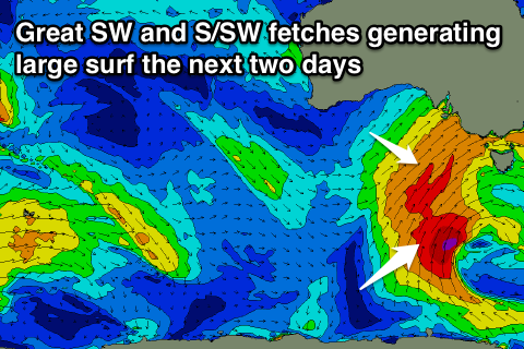 But coming back to tomorrow, and we'll see the swell swing a little more SW in direction and become larger through the day, owing to a great fetch of SW gales being projected through our south-western swell window today and tomorrow. All this activity is being steered by a strong, pronounced node of the Long Wave Trough stalling across the south-east corner of the country.
We'll see a large long-period SW groundswell filling in through the day, building to 8ft on the sets across the Surf Coast through the afternoon with 10ft sets developing on the Mornington Peninsula.
Conditions will remain great (but windy) for protected locations most of the day with a fresh to strong W/NW breeze.
Now our largest increase in size is due Wednesday, produced by a great fetch of gale to severe-gale S/SW winds being projected up through out southern swell window during tomorrow and then into and across Tasmania Wednesday.
With this a large and powerful S/SW groundswell will be generated for Wednesday, with 8ft+ sets due across the Surf Coast swell magnets through the morning, easing a touch later in the day, while the Mornington Peninsula is likely to come in around 10-12ft.
Winds look as if they'll remain favourable for protected breaks across the Surf Coast with persistent fresh to strong W/NW-W breezes holding all day due to another polar front approaching from the south-west.
We'll see the S/SW swell ease back into Thursday from the 4-6ft range on the Surf Coast and 6-8ft on the Mornington Peninsula along with strong W/NW winds again, giving into a W/SW change as the polar front pushes past us.
This polar front will inject some very cold air across us again while also producing another large and powerful S/SW groundswell for Friday, with a burst of severe-gale to storm-force S/SW winds being generated on our doorstep in our southern swell window Thursday.
The Surf Coast looks to build back to the 6ft+ range with 8ft+ waves on the Mornington Peninsula though winds look less than ideal with strong W/SW-SW breezes in the wake of the front. We'll have a closer look at this Wednesday.
Looking into the weekend, we'll see the S/SW groundswell ease away along with some similar sized SW groundswell energy with good conditions for the protected reefs on the Surf Coast and better offshores Sunday, but have a check back Wednesday for the latest update.
Comments
great session late morning before the weather got too radical.. was already pushing 5ft on the sets
Nice!!
A bit of #weatherporn for those interested. Check out the extent of this system. That speckled cloud is super cold air..
If thats weather porn, then surely its under the BDSM section.
Haha, horses for courses.
Theres a big storm surge along with a spring tide today .
Where is that Port Adelaide tide guage please ben , / craig ?
There's no observation data that I can see available sorry Clam.
Thanks craig .
Got a photo of waves washing way up beyond normal . Half metre of surge guesstimate, on a 2 metre predicted tide.
Colder than a mother in laws kiss in Vicco today
Cape Sorell has just registered a Max wave height of 13.6m..
Craig thats impressive !