Great weekend of surf, less so next week

Victoria Forecast by Craig Brokensha (issued Friday 14th July)
Best Days: Surf Coast Saturday, both coasts Sunday, east of Melbourne Monday
Recap
Tiny waves across the Surf Coast with small and windy sets fading from 1-2ft on the Mornington Peninsula.
Today an inconsistent new W/SW groundswell has filled in with clean sets to 3ft on the Surf Coast and 4-6ft waves on the Mornington Peninsula but with less than ideal winds.
This swell should ease slightly through the day as winds tend more W/NW and freshen.
This weekend and next week (Jul 15 - 21)
Today's inconsistent W/SW groundswell was the first of two due over the coming days, with tomorrow's looking slightly stronger and bigger.
This swell impacted Western Australian yesterday and today, produced by a broad fetch of severe-gale W/SW winds in our far western swell window.
The remnants of the storm linked to the swell moved under WA yesterday, continuing to generate strong W/SW winds in our swell window, with it moving in and across us overnight.
What we'll see is inconsistent long-period W/SW groundswell energy tomorrow morning, coming in at 3-4ft across the Surf Coast (possibly 5ft bombs at swell magnets), with 6ft to occasionally 8ft sets on the Mornington Peninsula. This swell will ease through the day followed by more consistent mid-period W/SW swell into the afternoon.
Winds are now looking favourable all day on the Surf Coast with a persistent W/NW-W breeze, while Sunday looks great across all locations with a fresh and gusty N'ly breeze persisting all day.
The W/SW swells will ease though from 3ft+ at magnets on the Surf Coast and 5-6ft on the Mornington Peninsula.
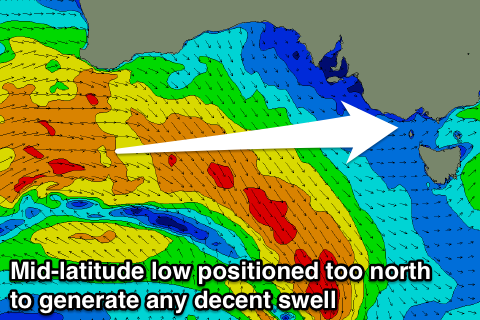 Sunday's gusty N'ly wind will be associated with a strong mid-latitude low approaching from the west but the fetch on its northern flank looks to sit too north to generate any decent swell for us at all.
Instead we're expected to see the surf continuing to ease Monday from an inconsistent 2ft on the Surf Coast and 3-4ft on the Mornington Peninsula.
Fresh and gusty winds from the N'th are likely to persist, favouring the Mornington Peninsula with the small swell, swinging more NW Tuesday but with no major size.
Our models are continuing to pick up moderate levels of W'ly swell, but I feel this is a touch out with inconsistent 2ft sets max on the Surf Coast and 4ft waves to the east.
Once the mid-latitude low finally pushes across us mid-week we're likely to see a stormy junky waves developing across the coast, but to no major size at this stage. More on this Monday. Have a great weekend!
Comments
Looking great this morning!
Smaller today than yesterday but super clean across the beachies.