Fun swells continue for the Surf Coast

Victoria Forecast by Craig Brokensha (issued Monday 10th July)
Best Days: Surf Coast Tuesday, both coasts Wednesday, Surf Coast Friday, early Saturday and Sunday
Recap
Small clean waves on the Surf Coast Saturday, hanging in around an inconsistent 2ft, while Sunday saw a good new but infrequent SW groundswell filling in as offshore winds persisted.
The Surf Coast reefs offered good 3-4ft sets with offshore winds all day, while the Mornington Peninsula was larger but bumpy and average.
This morning the swell has eased off a touch back to 2-3ft on the Surf Coast with clean conditions, while the Mornington Peninsula was bumpy with a touch too much west in the wind.
A new mid-period SW swell is due this afternoon and Cape Sorell is on the rise, so expect an increase in size after lunch. Winds will swing more W'ly keeping the Surf Coast reefs clean.
This week and weekend (Jul 11 - 16)
This afternoon's increase in mid-period SW swell was generated over the weekend and early this morning by a broad but relatively weak polar front projecting towards us. The front pushed through this morning, with an increase in size to 3ft+ due later today on the Surf Coast and 6ft on the Mornington Peninsula.
We should see similar sized surf through tomorrow morning across both coasts and conditions will be clean on the Surf Coast with a light NW tending variable wind.
 The Mornington Peninsula should improve into the afternoon with the variable breeze but Wednesday looks much better with easing 4-5ft sets and offshore N/NE winds. The Surf Coast beaches should be the pick with easing 2-3ft waves.
Thursday will mark a low point in swell with tiny leftovers across the Surf Coast and inconsistent 2-3ft waves on the Mornington Peninsula with a strong N'ly wind.
As touched on last update, into Friday and the weekend some new W/SW groundswell energy is expected from a flurry of strong polar frontal activity between Heard Island and Western Australia.
Currently a strong front is generating a fetch of severe-gale to storm-force W'ly winds in our far western swell window, but will push east closer to us today before weakening early tomorrow.
An inconsistent long-period W/SW groundswell will head towards us, arriving Thursday evening and peaking Friday morning. Swell magnets on the Surf Coast should see 3ft+ sets on Friday morning with 6ft sets on the Mornington Peninsula with a fresh N/NW tending W/NW breeze.
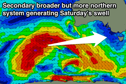 A secondary broader but more northward positioned polar front will generate a great fetch of severe-gale W/SW winds, producing a secondary long-period but more west W/SW groundswell for Saturday.
With the extra west in the swell, the Surf Coast will see a little less size, but we can expect 3-4ft sets across swell magnets, with 6ft+ waves on the Mornington Peninsula.
Our models are incorrectly combining Friday's swell with Saturday's and over-forecasting the size.
Winds on Saturday at this stage look to possibly be W/NW early ahead of a SW change, with N/NW winds as the swell eases Sunday, but we'll look at this again Wednesday.