Plenty of waves for the Surf Coast; cleanest conditions later in the week

Victoria Forecast by Ben Matson (issued Monday 29th May)
Best Days: Wed: leftover, easing swell with a window of OK winds in Torquay. Thurs/Fri/Sun: good winds for Torquay with mainly small long range swells. Next week: plenty of surf on the cards.
Recap: Plenty of surf over the weekend as a new swell built across the coast, with favourable winds best suited to the Surf Coast. Sunday afternoon’s strong pulse eased back into today though we’re still seeing 3-4ft sets across the Torquay stretch with bigger but much more wind affected surf east of Melbourne.
Note: our computer model surf forecast graphs will be a little funky for the next day or two.. read more here: https://www.swellnet.com/forums/website-troubleshooting/352217
This week (May 30 – Jun 2)
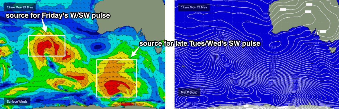
Tuesday looks pretty tricky all round. We have the leading edge of a new long period groundswell expected to make landfall in the morning, but it’s not expected to begin building properly across central Victorian beaches until the middle of the day, and by this time at the associated cold front will have pushed across the coast, swinging early NW winds around to the SW.
I haven’t had time to hindcast the specifics of the early incarnations of this system but a brief look at the weekend's satellite data didn’t show any major strength in the fetch (i.e. nothing greater than 40-50kts), and the bulk storm track was quite far south, so I’m going to downgrade Craig’s Friday estimations a little, expecting a kick to between 3ft and 5ft in Torquay by late Tuesday and holding into Wednesday morning.
Tuesday morning will therefore start off much smaller but there’ll be a very brief window of early W/NW winds at dawn, offering clean conditions on the Surf Coast for an hour or maybe two. Don't expect anything worthwhile east of Melbourne.
Wednesday will see much better surf opportunities all round with overnight (Tuesday) S/SW winds in most areas expected to swing to a light W/NW in Torquay for a few hours around dawn, and a steady though inconsistent swell in Torquay. Expect an easing trend throughout the day. Winds will probably veer back to the SW during the day though.
Elsewhere, expect lingering SW winds through the middle of the week with no great options anywhere.
Thursday morning should see small clean waves in Torquay with winds back to an all-day W/NW flow. These winds won’t favour anywhere east of Melbourne but with small residual lines of groundswell in Torquay we should see some fun 2-3ft waves across the reefs. Set waves will be very inconsistent at times.
Late Thursday, a new W/SW swell is expected to push through, providing energy for Friday morning. This swell will have been generated by a cut-off low currently forming west of Margaret River, which is then expected to take an unfavourable SE track perpendicular to our swell window over the coming days. This will limit swell potential for us, in fact we’ll probably see the most size form the pre-frontal NW fetch (poorly aimed, but strong and wide enough to allow for some spread back into Bass Strait).
However this swell won’t offer much size for the Surf Coast. Our model (note: the model data is fine from about Friday onwards) is estimating 3ft sets in Torquay but I think this is overly optimistic. I’ll peg size at a every inconsistent 2-3ft, mores the lower end than the upper end, and very inconsistent at times. Conditions will be clean though.
East of Melbourne expect double the size at the open beaches with average conditions under a W/NW flow. There won’t be enough size for Western Port either.
This weekend (Jun 3 - Jun 4)
Mainly small swells are expected this weekend.
Whatever we see Friday will be easing through Saturday and winds should be light, offering minor inconsistent surf across the Torquay stretch and (hopefully) fun and reasonably clean beachies east of Melbourne.
On Sunday, a new long period groundswell is expected to arrive, generated by a very intense series of fronts currently developing near Heard Island.
The enormous travel distance and the northern position of the storm track (relative to our swell window) means we’ll see long breaks between set waves, and quite a lot of west in the swell direction too.
Torquay should pick up some 2-3ft+ sets by the end of the day (smaller earlier), and conditions are expected to be clean with pre-frontal NW winds. East of Melbourne will be much, much bigger but more challenging with these winds.
So, the weekend plan should be a possible surf east of Melbourne Saturday, and then west of Melbourne Sunday.
Next week (Jun 5 onwards)
A very active frontal passage through our far and mid-range swell windows will keep the Victorian coast very busy through much of next week. It’s too early for specifics but things are lining up for an extended period of great waves. More on this in Wednesday’s update.
Comments
Tide's a little high but it's clean and empty at TQ this arvo.
In amongst Swellnets vast vast network of knowledgeable folk. Is there any sand scientists or marine biologists. Whatever. That can come and have nothing less than a royal inquest to the phenomenon that is Portsea. The fact that has been two sandbars, one close and the other further out that run perfectly parallel to shore, that havent budged in too long of a time to remember, is a major concern. You used to be able to laugh jt off but now, when you cant even have a shit grovel, is crazy. Maybe test to the sand. No surprises if it comes back high in cement.
Our main surf beaches far west vicco , used to have classic banks with big fuck off rips , from the 90s to the present these rips slowly filled in under a couple of decades of progressively smaller winter swells that now also seem to have a more southerly bias , this swell direction seems to cause that two sandbar and parallel channel you talk about Nick , the only swells that seem to remove this inner bar and split the banks with a decent rip are winters of very large westerly biased swells , starting to think i will die and old man before i get some real waves on a classic bank again ...
https://www.swellnet.com/forums/wax/279141
There was nothing but big WSW swells from lows that hugged the aus coast last winter though? My regular go to on the peninsula hasn't had a rideable bank since Nov last year but the beachies a little further south have been great, its all swings and roundabouts
Channel dredging has had an impact. Prior to that the Flinders beach at the Gunnery was mostly rocks, now it is covered in Sand and resembles a Westernport Beach like Point Leo.
We dodged a bullet Port of Hastings was dropped, they would have had to dredge for supertankers!