Great Wednesday, good again early next week

Victoria Forecast by Craig Brokensha (issued Monday 13th March)
Best Days: Wednesday, early Thursday on the Surf Coast, Saturday and Sunday east of Melbourne, Monday east of Melbourne
Recap
Small clean surf Saturday with 1-2ft sets lingering at swell magnets on the Surf Coast, 2-3ft on the Mornington Peninsula, smaller and average into Sunday with E'ly winds.
Today the surf remained small to tiny along with onshore winds across the Surf Coast and a lighter SE breeze to the east.
This week week (Mar 14 – 17)
Tomorrow morning will remain small to tiny across the state, but conditions will be cleaner on the Mornington Peninsula with a light N/NE offshore and small inconsistent 2-3ft sets.
Of much greater importance is the new long-period SW groundswell due Wednesday morning, with a strong but distant polar low generating this swell late last week and over the weekend.
We're looking at good strong but inconsistent 3ft sets on the Surf Coast (3-4ft at magnets) and 5-6ft sets on the Mornington Peninsula with possibly the odd bigger sneaker in the mix.
Conditions look excellent for the beaches on both coasts with a moderate to fresh N'ly, tending more N/NE into the afternoon and possibly easing a little. This should create a full fun day of surf on the beaches.
 The change due Thursday has been brought forward and an early fresh N/NW wind will give into W/SW change late morning, so the Surf Coast will be best early but small with easing 2ft+ sets.
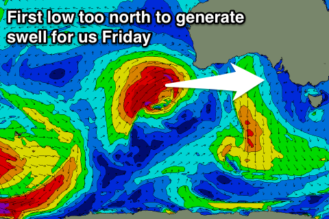
This change will be from the remnants of a vigorous low pushing up and into WA over the coming days, but while our charts are showing a bump in groundswell, in reality not much size is due at all.
The low will be too far north and the swell too west to generate any major size, but this long-period signal will be mixed with some W/SW windswell from the back of the front moving through Thursday.
We're not due to see much above 2ft on the Surf Coast Friday and 3-4ft on the Mornington Peninsula but with poor SE tending E/SE winds.
This weekend onwards (Mar 18 onwards)
A small reinforcing W/SW swell with a morning E/NE breeze is due Saturday. This swell will be generated by a weak mid-latitude front moving under the country mid-late week.
The Mornington Peninsula should see 3-4ft sets continuing through the morning (1-2ft Surf Coast), smaller into the afternoon and Sunday morning as winds swing more N'ly.
Longer term another strong but poorly aligned front firing up towards WA should produce some slightly better long-range W/SW groundswell.
We may see this swell kick later Sunday, with a peak Monday to an inconsistent 3ft on the Surf Coast and 4-6ft on the Mornington Peninsula under N/NE winds. More on this Wednesday.
Comments
Good to see the swell kicking later today with light winds. Tomorrow is shaping up really nice!
Good swell on cdc graph today craig