Good swell over the weekend, improving from Sunday

Victoria Forecast by Craig Brokensha (issued Friday 24th February)
Best Days: East of Melbourne Sunday morning, beaches Monday morning, late morning Tuesday, Wednesday morning
Recap
Another morning of tiny surf yesterday, increasing a touch through the afternoon but with onshore winds.
This morning some better size to 1-2ft was seen on the Surf Coast and 2ft on the Mornington Peninsula but with onshore winds.
We should see a good new W/SW groundswell building into this afternoon across both coasts but a freshening SW'ly will continue to create poor conditions.
This weekend (Feb 25 - 26)
The weekend forecast is now looking slightly better for selected locations on Sunday.
But coming back to tomorrow, and our best pulse of W/SW groundswell is still on track, with a great fetch of W/SW gales moving under the Bight yesterday, over the active sea state generated by the storm responsible for this afternoon's swell.
The Surf Coast should see 3-4ft sets at exposed breaks with 6ft+ sets on the Mornington Peninsula, but a gusty S'ly wind will create terrible conditions, tending more S/SW mid-afternoon and then S/SE near dark.
Into Sunday the swell should ease back from 3ft and 5-6ft respectively and the trough responsible for the poor winds will dip a little further south-east resulting in winds tending E/NE across both regions through the morning.
This will create improving conditions east of Melbourne, but the size of the swell could be an issue at some spots. Expect SE sea breezes to kick in through the afternoon as well.
 Next week onwards (Feb 27 onwards)
The swell should continue to ease through Monday and winds are still looking good for the Mornington Peninsula as a light NE'ly develops through the morning. The Surf Coast should also improve as winds tend more variable from the N'th mid-late morning.
Easing 2ft+ sets are due on the Surf Coast with 3-4ft+ waves on the Mornington Peninsula.
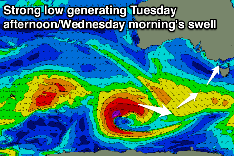
A low point in swell is expected Tuesday morning, but a kick in surf is due into the afternoon, from a small and intense polar low tracking east-southeast under WA.
A fetch of gale to severe-gale winds should produce a good SW swell to 3ft on the sets across the Surf Coast and 4-5ft on the Mornington Peninsula, but a morning N/NE breeze will give into SE sea breezes.
Wednesday looks better as the swell eases from 2-3ft and 3-5ft respectively under a light morning offshore wind.
Longer term there's no major swells showing on the charts, but check back here Monday for more on this. Have a great weekend!
Comments
A lot of paramedics down at 13th this arvo - looks like a serious situation