Fun Saturday (from mid-morning) average into next week

Victoria Forecast by Craig Brokensha (issued Friday 5th February)
Best Days: From mid-morning tomorrow, dawn Sunday
Recap
A good pulse of W/SW groundswell was seen yesterday, but conditions were poor with a fresh and gusty S'ly wind.
Today the swell has eased back a touch, but a new reinforcing SW swell should fill in and provide 3ft+ sets across the Surf Coast with 6ft sets on the Mornington Peninsula, but with limited options under this SE breeze.
This weekend (Feb 6 - 7)
A drop in swell is due through tomorrow and conditions will be less than ideal at dawn, improving through the day across both coasts as a dawn E'ly breeze eases and tends more N/NE through the morning and then variable into the early afternoon. Mid-late afternoon sea breezes are expected but conditions should be cleanest late morning, through the middle of the day.
The Surf Coast should ease from 2-3ft, with 4-5ft waves on the Mornington Peninsula, while a small reinforcing SW swell Sunday should keep 2ft sets hitting the Surf Coast with 3-4ft waves on the Mornington Peninsula.
Variable winds are expected early morning Sunday, but a shallow SW change is forecast to move in around 7-8am before freshening from the S/SW into the afternoon. So aim for a dawn surf if you're desperate for a wave.
Next week onwards (Feb 8 onwards)
Lingering onshore S/SW winds and a small W/SW swell will continue to create poor surfing conditions Monday, persisting form the S/SE but only weak Tuesday as the swell bottoms out.
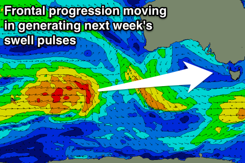 From Tuesday afternoon fun pulses of SW groundswell are due to push in, one after the other owing to a weak but persistent polar frontal progression pushing in under the country from the south-eastern Indian Ocean.
An initial increase later Tuesday to 2-3ft is expected on the Surf Coast and 4-5ft on the Mornington Peninsula, peaking Wednesday morning to more the 3ft and 5ft range respectively, but then hovering between 2-3ft and 4-5ft through until Friday morning.
Unfortunately winds are due to persist from the SW through Wednesday and Thursday, S/SW Friday, but the Torquay region may see better early W'ly winds. We'll confirm this on Monday.
Longer term, some stronger polar frontal activity should produce better pulses of SW groundswell for next weekend, but check back here Monday for more on this. Have a great weekend!
Comments
There's always a lot of talk about sand banks in these forums, I'm mostly interested in the dunes.
Can anyone tell me which dune gives the best vantage point of the flagged beach area at Portsea back beach?
Gaz.
I usually set up about 50m south of the flags. Plenty of cover / foliage and a nice elevated view. Hope that helps.
Cheers Adam, you wouldn't have seen me there - but I was watching. Plenty of great sets pouring into the peninsula all weekend.