Great period for the Surf Coast, starting very slow from tomorrow

Victoria Forecast by Craig Brokensha (issued Friday 26th June)
Best Days: Every day on the Surf Coast (Mornington Peninsula early Saturday)
Recap
After a good kick in SW groundswell Wednesday afternoon, yesterday revealed smaller but fun clean easing 3ft+ waves across the Surf Coast with offshore tending lighter onshore winds. The Mornington Peninsula was solid but bumpy.
Today the swell was small and clean on the Surf Coast, with a new short-range W/SW swell due to reach the 2-3ft range this afternoon as winds remain offshore.
The Mornington Peninsula was workable and around 4-5ft with a bit of W/NW bump and a further increase to 4-6ft is due this afternoon.
Cape Sorell has just picked up the leading edge of the first pulse of super inconsistent long-range W/SW groundswell due tomorrow, and no considerable size is due later today, with the bulk of the swell sitting more in the 18s range which is due tomorrow afternoon.
This weekend and next week (Jun 27 – Jul 3)
There's been no real change to the tricky weekend forecast, with a very inconsistent long-range W/SW groundswell due to fill in through tomorrow ahead of a slightly better pulse through Sunday afternoon, mixed in with a medium-range and larger groundswell pulse mid-late Sunday afternoon.
The Surf Coast should build to a very infrequent 3-4ft through the day at swell magnets with 6ft to occasionally 8ft bombs on the Mornington Peninsula under fresh N/NW tending NW and then W/NW winds. The morning is likely to be smaller.
Sunday should start around a similar size to Saturday but into the afternoon the mix of stronger but very inconsistent W/SW groundswell is due, with the larger and more consistent medium-range W/SW swell.
The long-range swell should build to a very inconsistent 4-5ft across exposed breaks on the Surf Coast with possibly rare 6ft bombs at swell magnets while the Mornington Peninsula should build to 8ft+.
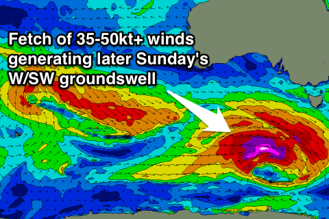
Over the top of this swell though will be a more consistent and larger W/SW groundswell developing, generated through today and tomorrow by a vigorous polar low pushing quickly from the west. A fetch of severe-gale to storm-force winds will be projected through our swell window, and while the speed and track of this low isn't ideal, the strength will slightly overcome this.
The Surf Coast is expected to build to an easy 6ft+ across exposed breaks, with 8ft bombs likely into the evening, while the Mornington Peninsula should kick to 10-12ft.
Winds should be favourable and offshore from the W/NW-NW across the Surf Coast, and the afternoon is now looking a lot better with only a shallow and weak W/SW'ly due mid-late afternoon.
Both swells are due to ease back steadily through Monday under offshore NW winds. The Surf Coast is expected to offer 5-6ft sets early at swell magnets Monday, back to 3-5ft through the afternoon, and the Mornington Peninsula easing from 8ft. Winds will slip back to the W/SW mid-late afternoon and not do too much damage to the Surf Coast.
Two reinforcing W/SW groundswells are due into Tuesday and Wednesday morning, the best Wednesday morning from a broad fetch of pre-frontal W/NW gales pushing under the country Sunday and Monday.
The Surf Coast at this stage is looking to offer 3-4ft+ sets early Wednesday morning with 6ft to occasionally 8ft sets on the Mornington Peninsula under morning NW tending W/NW winds.
Longer term a good moderate sized SW groundswell is due later Thursday/Friday, but we'll have a closer look at this on Monday. Have a great weekend!
Comments
Satellite observations have already picked up stronger winds than the models had forecasted for this morning around that low linked to Sunday afternoon's pulse, 50-60kts there.
If this is the case later Sunday's forecast could be a touch under-cooked.
Thanks Craig as usual, all jokes aside you to a terrific job for us, and Im sure the trolls will be back.
But anyway:
When you say under cooked, do you think an extra ft or 2 or significantly larger?
Not significantly larger, and I'm not going to change the forecast, but near dark Sunday will be one to watch for bigger sneakers.
More so just a note to keep in mind.
Did anyone see my barrel this afternoon?
Yeah but you weren't really in it!
Oh really :-( I'm pretty sure I was.
Hey Craig, did you see it on the Torquay webcam? I was riding a red board. If so can I get a copy please?
Thanks guys!
Mine too Craig I was on the Hypto Crypto
hey craig - do you think the w/sw winds on monday arvo will remain into tuesday?
Swanny, please don't waste Craig's precious time with these tivial questions, he's looking for my shack on the replay.
Have you found it yet???
The swell period was noticeably long this afternoon. I didn't time them but it felt like 20s or more. Never noticed it so clearly as today.
Yeah the Point Nepean buoy picked up 25s through the morning and hovered around 22-23s all day.
Yeeew! Save some for me boys, I'm on my way down and it looks like it's PUMPING!
Is it 6-8ft yet? Might be time for Swellnet to put up it's hand and say "We overcalled it again. We should have listened to Vic Local. He's boring, obnoxious, but he did warn us that we were way too optimistic about this WSW, long period swell that formed way out beyond WA".
I dunno Vic Local, generally when I'm talking about size I add a little bit to the forecast - by the time people get down there and find out that I've overcooked it a little they still have a crack anyway.
Vic local. Just wondering what size you'd call Sunday arvo? Bells / winki.
As far as wkends crowds go, I thought it was fairly quiet.
I've just watched a couple of macking sets going through one of the points down my way...double overhead and I timed them at 18 secs. Ive seen it bigger, but not very often. They cleaned up every one in the line-up... broke about 60 yards out behind everyone. Broken leggies and long cold swims. Two guys who paddled out just before dark were cleaned up and didn't even get to the take-off. They were forced to paddle in at a nearby rivermouth.
Where's down your way murphy? (Roughly)
West of Torquay about forty five minutes...there were lulls...which made it even worse...you paddle into the take-off, then ten minutes later you get cleaned up by a sneaker.
They were 10ft sets at a local bombie that I was looking at this arv on the morn pen.
Im guessing bells would have a couple of 8 footers
Surfed wanki poop this arvo just after low. It was really slow going and Lully with the usual pack of wankers continually snaking up the inside. I thought I would sit wide for the occasional wide set and avoid the peak circus. Was a shit strategy as in 1.5 HR surf only one came through wide. It was a solid four foot with 5 ft sets every half hour. Pushing 6 ft if you want to talk it up. Was fairly fat, but there was a few odd shacks.
was way too Lully for how many heroes there were. It was a five out of ten for me as far as winki goes. Back to unzud mid week. Looking forward to surf amongst people who know what a line up is. Nice to be in the water though after a month of bashing steel.
VicLocal yep.
From Toddy Rosewall "Yeah i sat and watched the last 20 mins before dark at Winki and there was about five 8ft sets in a row"
You said it would be really inconsistent. 5 sets in twenty minutes, 18 second period, say 4 waves in a set - that means less than three minutes between sets. That's super consistent if you ask me.
Or maybe your mate was exaggerating just a little?
The long-range swells, yes, really inco, the larger medium-range swell not. This is all spelled out above..
"Sunday should start around a similar size to Saturday but into the afternoon the mix of stronger but very inconsistent W/SW groundswell is due, with the larger and **more consistent** medium-range W/SW swell.
The long-range swell should build ......
Over the top of this swell though will be a **more consistent** and larger W/SW groundswell developing, generated through today and tomorrow by a vigorous polar low pushing quickly from the west."
Ah ok, I think I get it. But could you maybe try to make it a bit clearer and drop the weatherman jargon for those of us un-trained in the art of weather forecasting?
The late pulse in swell didn't worry me anyway, as I was already on the V-Line back to Melbourne ready for work tomorrow.
"could you maybe try to make it a bit clearer and drop the weatherman jargon"
Hahahaha...surely this is a pisstake.
Sorry, yes that was a misstake. I should really write 'weather-person' in these politically correct times.
Was it the word 'inconsistent' that got you mate? Or maybe 'groundswell'?? 'Storm' perhaps?
Those weather-people and their darn high brow wordsmithery.
5 sets in a row or five bongs.?
sounds like he was pulling dream cones .
I checked just on dark and didn't see anything other than 4-5ft Maybe 6 if you're from QLD. I reckon Inzider summed up the conditions pretty accurately. You guys have been talking about this swell for over a week and it simply didn't get anywhere near the hype. If it wasn't for that more local fast moving storm that moved though the swell window over the last couple of days, the huge Indian Ocean storm that's smashed WA would have been lucky to create 4 foot waves on the surf coast.
Totally agree, hence my forecast for Saturday and this morning only being really inco 3-4ft.
This swell was never hyped up for WA, and even SA around Adelaide.
Craig Maaaaaaaaate.
You were calling 6ft + with 8ft bombs late sunday. WA deserved the hype. Surf Coast didn't. Your forecast for the morning was spot on, but it simply never got close to a 6ft+ day. As soon as the swell period starts going over 16 seconds, it's a very clear sign of a inconsistent surf with too much west, and too much distance from the source. You guys really should drop your forecast height by 30% when swell periods start climbing past 16+ secs .
Not when the 16 second surf is generated right on your door step.
This 16s (17-18 really) was generated bascially right on the door step of Vicco. It wasn't from the Indian Ocean.
Here's satellite observations south-west of Vicco Saturday.
I still don't quite understand how the northerly wind in the map above can generate swell for the Surf Coast.
Get a globe , draw a line from Heard island to Cape Otway . Then draw another line from the centre of the map aboves lat and longitude references to Cape otway also .
The second line is less horizontal . Capiche .
But wouldn't the wind blow the waves away from us????
No need to justify your forecast Mr. Craig, as those of us who were In the water in the last hour of light saw some 6 footers and a few slightly better.
The Point nepean wave buoy (who was also in the water) was recording that @ 5:00pm it was:
3.76 meters (significant height)
5.37 (max height). wave period around 17sec mark. Swell direction about 194 to 197 degrees. And yes there is some loss of size due to refraction but not a huge amount. And yes the arms are sore and yes Ill be getting in first thing in the morning for a few!
cheers bloke
Mate you're just chucking up anything to confuse the average punter on this site. Like I said before, that second storm (in your picture) was never going to be a great swell producer for us because it was travelling very quickly though the swell window and the track was all wrong.
You guys forecast from Sydney and don't appreciate the importance of direction and swell period down here. You routinely over predict size when the swells have plenty of west in the swell. Whenever you under call size, 9 times out of 10 it's on a very south swell. This weekend was just another perfect example of an overhyped westerly swell.
My job is to know an area, coastline and how swells perform/don't perform.
You're saying I don't understand the importance of direction.. I make tough calls every day of the week, taking in every variable possible and to think I don't understand that west swells are less consistent, smaller and don't perform as well on the Surf Coast compared to SW or S/SW which get straight in there is quite insulting.
I put my money where my mouth is nearly every weekend chasing waves, and hardly end up empty handed. Probably put in more effort than 90% of the population and this all comes down to knowing each areas idiosyncrasies. I have a pretty full understanding of Vicco and the Surf Coast, which I used to my advantage only 4 weeks ago.
You said the Surf Coast wouldn't get a wave when the first article was penned... every report and photo I've seen from today and even yesterday looks pretty bloody good.
Mate, I never said the Surf Coast "would never get a wave". Stop verballing me.
Forecasting isn't a pure science and nobody expects you to be right 100% of the time. It's not chemistry or engineering. Anyone who works in the sciences needs to evaluate their results. If your overcalls to under calls ratio was 1:1 then that's perfectly acceptable. When this ratio starts getting out of whack (like yours is) it's time to reevaluate how you make the forecasts. Anyone who is serious about improving their skills / output would sit down and evaluate their modelling. You seem a little defensive or unwilling to do this. Maybe just maybe, you underestimate how much swell direction and swell period impact the surf down here?
I'm entirely comfortable with my critique of your forecasting and have been spot on when predicting your overly ambitious forecasts for this coast. this weekend was just another example of that.
Even on the west coast some spots cop more swell than others. From where I was watching just on dark, the westerly angle was obvious. Some sets were running along the coast and just hitting the point I was watching...and some were just missing but every ten minutes or so, a set would hit just right and were easy double over head and swinging wide into the bay...five to six waves per set and two monsters per set as well- big fat and heavy. I can hear it now outside my window and it sounds pretty big...big enough to consider those rare sheltered coves that nobody knows about.
VL ,
Your a muppet .
It's been offshore on 90 % of the Vicco Coast for the last 2 -2 +1/2 days . 1 +1/2 of them weren't forecast a few days out by anyone .
If you couldn't find a wave over 8 ft relatively uncrowded during this period then it is you sir that doesn't know shit about this coast .
PS , when the period is higher , the outgoing tides effect on the swell ( increase ) to the surf coast is magnified , due to more refraction ontop of the tidal effect . They know about it , they wrote about it . It may have started from a thread of which myself and Brutus spoke of it . But they followed it up with an article .
The proof is on the Pt Nepean buoy readings .
How about you quit whingeing , and start learning .
Murph , lose the " river " talk please . People might inexplicably find something they know naught of . Ta
River talk?...you're not serious are you? ...I think you're over-reacting.
Dunno, I saw some size out there. A couple where the back of the wave peeling into shore was the height of me, but I'm under 6ft. It was bigger this arvo than yesterday arvo. Sat wide where I was, pack was cleaned up by a couple but again it wasn't the best strategy as of lack of consistency. Nice crew on both days, tip of my hat to you all. One bloke got an absolute bomb on one of the reefs (away from the pack of wnkers) that made him look quite small indeed.
TBH I can get carried away with the 'hype' of a swell and froth like the best of us when the forecasts start coming in, froth a week in advance.
Are you talking about the entire Vic coast Southey? I've only been referring to the Surf Coast for this entire thread. If you reckon it's been 8ft on the Surf coast for the last 2.5 days you're off your rocker. I've surfed the last three days and it's been between 3 and 5 ft max. 8ft pfffft whatever.
Quit whinging and step up . If it's too small and packed get in your car !
Murph , just lose the references to places that don't have ASP events that's all . You could just say somewhere else . I didn't get Agro , I just requested . Agro would be an over reaction .
Read the post...what exactly is your problem. I made an innocent comment and made such a vague reference to the place that it would be hard for anyone who doesn't know this place to figure out... but no, that's not good enough for you. I could have described it in a lot more detail. Read the post...I said it was big and fat...not overhead and barrelling. Again...and just so you do understand my point...I made an innocent comment. And you come in trying to act tough. You've got a bad case of soul-surferitis mixed up with good old fashioned localism. If anyone here has a touch of whingeing - its you.
its pretty simple really . this isn't a guiding site .
ie : if you travel x mins in x amount of direction ladadadadaddadaalalla @ something with a x , and the waves were x .
just use " somewhere else " its a pretty simple request really . people from all over read these threads, no need to go into details .
I hope erryone had a stellar weekend in the water!?? Holyshitballs that was amazing!
Deffo noticed it pick up in the last half an hour before dark, WELL overhead!
Ninch comes through with a win for sure.
Cheers craigonator for the forecasts, your a wizard, you always hook us up with the good stuff! Soppybottom aka viclocal is a turnip .
I had a good fun surf, not much more. Amazing no, onshore seabreeze yes. Craig plays to his market, frothers. He throws peanuts and the monkeys come, excuse me while I sit in the corner and scratch my arse.:-)))
Interesting post on FB from Mikey Brennan, regarding the last hour of the day Sunday at the South Arm, Tasmania (and the similarities to what Todd Rosewall reported at Winki late Sunday too):
"Today was epic but an hour before dark this beachie turned into evil carnage, intimidating to say the least 6+ scarey death pits. Glad to share the beatings and some mental shacks with the crew, saw some crazy shit go down".
S/W winds, some one throw me a banana.
Hey Dick Yokel, if you are so good at forecasting then go elsewhere you Troll.
From Bells Beach Surf Sanctuary Facebook page
"Winki late yesterday afternoon, how big would you call it?"
Ross Clarke Jones has released a T.C. doll . !?
Clearly they are just product testing , as its natural habitat would be bigger than that again .
They've also struggled with the miniature jetski .............
VL you there....?
Jeez it does look like Ross doesn't it!
2ft hawaiian
:-))
Strangely, we haven't heard from Vic Local since Sunday night.
Are you worried about him? Maybe he couldn't find a river to paddle into.