Excellent week, pumping Wednesday/Thursday

Victoria Forecast by Craig Brokensha (issued Monday 28th July)
Best Days: Every day over the coming period until Friday afternoon and Saturday
Recap
A slight increase in W/SW groundswell was seen on Saturday to 2ft on the Surf Coast and either side of 4ft on the Mornington Peninsula but W/NW winds favoured locations west of Melbourne.
Into Sunday the beginnings of a new long-range W/SW groundswell were visible to 2-3ft on the Surf Coast and 6ft+ on the Mornington Peninsula under local offshores. The swell kicked even stronger into the afternoon but was very inconsistent with 3-5ft sets seen on the Surf Coast (above expectations) and 8ft bombs east of Melbourne.
The swell has dropped back a touch into this morning as unexpected N/NE winds favoured locations east of Melbourne and the Surf Coast beaches, but we should these swinging N/NW through the day, improving conditions on the Surf Coast reefs.
This week (Jul 29 - Aug 1)
Yesterday afternoon across the Surf Coast was just a warm up of what's to come!
This week is looking to be one of the best we've had all winter with a series of very strong, broad and back to back frontal systems currently set to push towards us under the influence of the Long Wave Trough.
Firstly, a vigorous mid-latitude front pushing under WA and through the Bight yesterday and today is generating a medium sized W/SW groundswell for tomorrow that should kick strongly into the afternoon. Swell magnets on the Surf Coast should build to 3-5ft into the late afternoon with much larger 6-8ft+ sets on the Mornington Peninsula under strong N/NW tending NW winds.
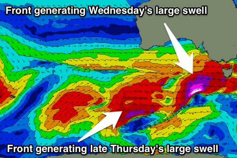 Of greater importance is the active sea state the front responsible for tomorrow afternoon's swell generates; with the strongest of all the fronts due to move in and over the area, generating an additional fetch of severe-gale to sub-storm-force W/SW winds. Due to the pre existing sea state, open ocean swell wave heights will be amplified, with a large and powerful W/SW groundswell being the end result.
This swell should fill in Wednesday and peak through the middle of the day/afternoon, with 6ft+ surf west of Melbourne and 8ft bomb sets at Bells/Winki with larger 10-12ft surf on the Mornington Peninsula.
Winds look excellent as well, holding fresh to strong from the NW all day, creating a full day of pumping surf.
A temporary drop in size is due into Thursday morning, but not as much as the models are indicating. Probably more so to 4-5ft on the Surf Coast and 6-8ft on the Mornington Peninsula.
Into the afternoon though another pulse of large SW groundswell is due, generated on the back-side of the system generating Wednesday's swell and further away from us.
Due to these factors the swell is expected to be a touch less consistent and also a touch smaller. In saying this the Surf Coast should see 6ft sets again into the late afternoon with 8-10ft waves on the Mornington Peninsula. Winds will remain good but not as perfect as Wednesday with a strong N/NW tending W/NW breeze.
Friday morning should still be solid and in the 5-6ft range across the Surf Coast, but you'll have to surf during the morning as a poor S'ly change is due through the day after morning W/NW winds (bringing an excellent week of surf to an end).
This weekend onwards (Aug 2 onwards)
One final pulse of large W/SW groundswell is due through Saturday morning, generated by the final blow in this strong frontal progression during the week.
A vigorous polar front projecting north-east towards SA will generate a fetch of severe-gale to sub-storm-force winds less than favourably though our swell window, but large levels of W/SW groundswell will still spread out radially from this storm and peak in the 6ft and 8-10ft range respectively but with onshore S/SW tending SW winds.
Sunday will be much better as the swell eases from 3-4ft and 6ft+ or so respectively under offshore NW tending W/NW winds, but we'll review this Wednesday. In the meantime, plan around the coming week!
Comments
Yippee!
Craig... We chatted last week... "monster low".... lol..... Well, 8 foot plus and 12 foot mornington is getting up there.... Plus look at that cyclops forming below tassie thursday... What is your opinion re' southern and SE tassie?
http://www.metvuw.com/forecast/forecast.php?type=rain®ion=swp&noofdays=7
Much too quick SD and not well structured.
Here's two shots, 6hrs apart and you can see how far it's travelled to the east in that time, with an unfavourable ESE track and W/NW fetch.
Wednesday is certainly going to be interesting, I'm already a bit nervous!
Saturday looks exceptional Goofy ! ;-)
Calm down kids, your only going to disappoint yourselves yet again. Remember where you live and dial down your expectations accordingly.
Who said were only going to surf where we live Shaun? You'd have to agree it's a pretty impressive system
Goofy, you know full well being a native Victorian yourself, if we were paid a dollar for every great system that went past, we would not have to work again.
I reckon swell is going to be too westerly with the wind to strong at any of the reefs picking up the swell, hope I'm wrong it's been a shit winter.
Not too west at all Shaun, you'll be pleasantly surprised!
Here's the fetch for tomorrow's swell, perfectly in the swell window.
Comin to Gippsland are you goofy, good call. The snowy has great sand with all this rain of late.
Fuck all this talk of swell ... it never happens .... I might just fly teh fuck out of here on Friday .....