Strong NE swells all week, poor winds until Friday

Sydney, Hunter and Illawarra Surf Forecast by Ben Matson (issued Monday 15th October)
Best Days: Plenty of surf all week but local winds will adversely affect conditions until Friday. The weekend is looking the pick with better conditions (S'ly change Sat PM) and smaller surf size.
Recap: Saturday delivered a strong mix of swells in the 4ft range, and winds were light offshore for a few hours in the morning, offering clean conditions, before the onshores kicked in. Similarly sized swells persisted through Sunday and early this morning, though winds have been generally onshore. Wave heights have started to build throughout today and exposed beaches are now seeing choppy 5-6ft sets out of the NE.
This week (Oct 16 - 19)
Today’s Forecaster Notes are brought to you by Rip Curl
I’ve never been one to simplify a forecast when a thesis will suffice, but the fact is that the surf outlook for this week is relatively straight forward, in a broad synoptic sense anyway.
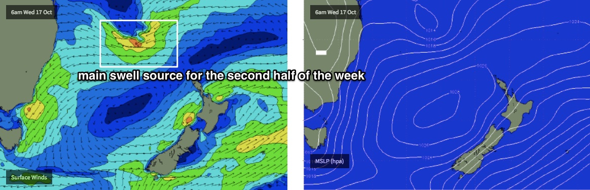
We’ve got a strong, near stationary high in the Tasman Sea and a deepening coastal trough that are generating gusty NE winds about Southern NSW.
This pattern is expected to remain in place until Thursday, so despite the presence of moderate to large swells from two sources - a short range NE fetch and a broader E/NE fetch from a trough meandering through the central northern Tasman Sea - surface conditions will largely remain unchanged. It’ll be very bumpy and choppy in the surf zone.
So with very few locations offering protection from this wind direction, it’s hard to get excited about the prospects of quality surf. Which is a shame as we’re looking at wave heights fluctuating between 4ft and 6ft throughout this time frame (smaller at south facing beaches, and across the northern Hunter).
There may be pockets of lighter winds from time to time scattered intermittently across the length of the coast, but with the regional synoptic flow remaining quite strong, we’d need a stiff offshore to iron out the lumps and bumps. This is very unlikely.
Your best chance for a wave will be on Friday when we’ll start to see a very gradual easing of size from both sources, but at a time when the coastal trough is expected to move offshore, resulting in light variable winds for much of the day. This should see a more pronounced improvement in wave quality though it’ll be quite a ways from anything notable.
And just to reiterate last Friday’s point: expect a significant drop in SST by the end of the week as these nor’easters trigger a local upwelling event.
This weekend (Oct 20 - 21)
A shallow southerly change is expected to push into the region on Saturday afternoon. Prior to its arrival we’ll see N’ly tending NW winds, and with slowly easing swells from the east (3-5ft down to 3-4ft), there’ll be OK waves about for the start of the weekend. Southern corners will be the pick into the afternoon.
Light variable winds in the wake of the change, and a further drop in size is then expected on Sunday, with most open beaches likely to be running around the 2-3ft mark.
Ideally, we need a half-day of fresh westerly winds to groom the ocean clean, but as this is unlikely we will have to work with what we’ve got. But at least there’ll be surf!
Next week (Oct 22 onwards)
Long term model guidance is holding the unstable trough pattern across the western Tasman Sea, which suggests more short to mid range E/NE swell for some time, and the possibility for a significant weather feature to develop on our doorstep.
Comments
Hi ben, what do you mean by potential of a significant weather feature, I understand it's to far away to be sure, but is it an ecl or something more. Thanks
Some form of enhanced trough or a closed low.
Take home point is: watch this space. Models don’t show much right now but I expect an evolution/upgrade over the coming days.
Ok thanks.
Just when the water was warming nicely... but I will gladly trade cooler water for some NE swell anyday.
Bring on the blue bottles
Haha yea, forgot about them....luckily I'll have the steamer on
.....I hate northerlies. Unless of course, you throw in a great south swell. Ta Ben