Stacks of swell ahead; end of the week onwards will deliver the best waves

Sydney, Hunter and Illawarra Surf Forecast by Ben Matson (issued Monday 8th October)
Best Days: Tues: small, but it'll be clean. Thurs PM/Fri: strong S/SE swelll with improving conditions. Sat/Sun: strong mix of S'ly and SE swell, with light winds in the mornings. Next week: extended run of short range NE swell.
Recap: The weekend delivered a mixed in the surf department, mainly average quality though sizeable SE swell with poor cross-onshore conditions on Saturday tending offshore at a few locations into Sunday as winds veered SW, even W/SW here and there. Size eased from Saturday’s 4-6ft to 3-5ft for Sunday, but rebuilt into the afternoon with a fresh pulse of short range easterly swell from the meandering low off the coast. Size then eased this morning, still 3-4ft across the Hunter though smaller elsewhere and with winds more generally offshore, we saw much better conditions across the coast. Size has continued to fall throughout the day.
This week (Oct 9 - 12)
Today’s Forecaster Notes are brought to you by Rip Curl
Tuesday looks rather non descript with light winds and easing swells. There’ll be small peaky beach breaks on the more favourable parts of the tide, but with infrequent 2ft+ sets easing to 1-2ft during the day, it’s not worth getting too excited about.
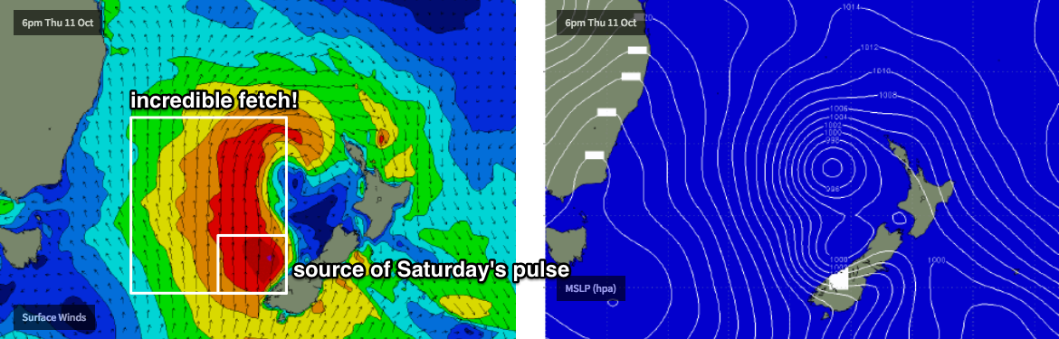
We’re then looking at a period of windy surf, as an advancing polar front merges with an eastward tracking upper and surface trough, forming a deep Tasman Low that’ll remain slow moving for a couple of days.
The latest model guidance shifted things around considerably over the weekend - first majorly upgrading Friday’s already-large estimate (from 10ft to about 12-15ft!) but it’s subsequently pulled back predictions over the last day or so, mainly due to a slight eastward relocation of the low, and a tweak of the primary fetch out of our swell window.
However, it’s only a small downgrade from Friday’s estimates, as we’re looking at well over three metres of southerly swell running at around ten seconds, and this should should push south facing beaches up into the 4-6ft range by very Wednesday afternoon (after a very small start early morning), pushing slightly higher from 5-6ft to 6-8ft throughout Thursday as longer period S/SE energy lake landfall from the actual Tasman Low: most of Wednesday’s increase will be short range energy in the lee of a gusty southerly change.
The good news is that with the low now expected to be positioned much further to the east, we’ll see less wind across the coastal margin as the swell peaks through Thursday - still up around 15kts+ at exposed regions - but it’ll abate further info Friday with manly light variable winds at most coasts. We’ll see easing size into Friday but early morning should still be somewhere up around the 5-6ft mark at open south facing beaches, ahead of a drop throughout the day.
All throughout this period, expect small surf at beaches not open to the south. But: as the swell event progresses, and the swell direction veers more east of south, we’ll see the size ratio tighten up a little (i.e. bigger proportional surf size at southern ends late Thurs/Fri, compared to Wed).
So, leave your run until late Thursday or Friday as this is when we’re expecting the most size and the best conditions.
This weekend (Oct 13 - 14)
This lovely big Tasman Low won’t be ideally aimed in the Tasman Sea, but it will be very slow moving and this will lend a lot of potential to our weekend forecast, thanks to a reintensifation around Thursday as a passing polar front gives it a nudge.
All weekend will see small underlying long period S’ly groundswell (from the related polar low) but we’ll see more size from sideband SE swell, that should manage 4-6ft sets at some point on Saturday and maybe even Sunday. Current model guidance (which should be taken with a grain of salt) actually has a couple of individual intensification periods - and thus two seperate pulses - so it’s hard to pin down the exact timing and size confidence, but I’d be leaning towards Saturday seeing the most size at this stage.
It’s also more likely that we’ll see the most size north from Sydney (than south), and winds should be light both days ahead of freshening NE breezes Sunday afternoon as a new high pressure system sets up camp in the Tasman.
So, we've got a bloody good weekend coming up, it would seem.
Next week (Oct 15 onwards)
Enjoying this troughy patten? Looks like there’s more to come, with Sunday afternoon’s NE infeed expected to bring about another coastal trough and some short range NE swell for Monday, that’ll likely persist for a few days in and around the 3ft range. Winds may be a little suss, but hey! It’s an active period on the synoptics, and there’ll be waves - that's all that counts.
Comments
Happy days. Any reason these breakdowns aren’t emailed anymore?
These forecasts are still emailed but our email provider - Mailchimp - is having some problems. And I’m having problems resolving this issue with them. Been driving me around the walk for the last week or so.
All good mate I was worried you’d canned them.
All your emails started to get into spam since couple of weeks ago. There is some painful process of getting off the blacklists...
Which is pretty shitful, considering the non-insignificant amount of money we pay for the Mailchimp service.
This is what I see when moved from spam to inbox. Might be helpful when talking to Mailchimp support
> Be careful with this message
> Gmail could not verify that it actually came from swellnet.zendesk.com. Avoid clicking links, downloading attachments or replying with personal information
> FROM: Ben at Swellnet.com [email protected] via mail220.atl101.mcdlv.net
It also says
> DMARC: 'FAIL'
Which is probably the main reason.
And here is support link with explanation what that is https://support.google.com/a/answer/2466580?hl=en
Last weekend's trip up to the MN coast along with the long weekend's surfing exploits has left me cashed out of brownie points a week early. I'll need to spin a real belter of a yarn to get the missus on board with this one!