Easing size ahead of a strong southerly swell, then an interesting E'ly swell next week

Sydney, Hunter and Illawarra Surf Forecast by Ben Matson (issued Wednesday 11th July)
Best Days: Thurs: small clean leftovers. Fri: late building S'ly swell though likely to be wind affected. Sat: large easing S'ly swell, though windy at times. Sun: moderate easing S'ly swell with offshore winds. Late Mon/Tues: light offshore winds and a strong E'ly swell, though biggest in the Far South (smaller across Syd/Hunter coasts).
Recap: Monday’s large S’ly groundswell eased slightly into Tuesday though was still pretty solid early with 6ft+ sets at south facing beaches. Wave heights eased further into the afternoon and overnight, settling around 3-4ft at south facing beaches. Conditions have been generally clean with light offshore winds.
Today’s Forecaster Notes are brought to you by Rip Curl

Lonely bank at Newcastle this morning

Early morning barrels at Shark Island
This week (July 10 - 13)
Want to receive an email when these Forecaster Notes are updated? Then log in here and update your preferences.
The rest of the week looks a little uninteresting, compared to what's already been dished up this week.
Today’s easing S’ly swell trend will persist through Thursday, leaving us with inconsistent 2ft+ sets at south facing beaches early, smaller elsewhere and abating throughout the day. As mentioned on Monday, a series of strong but poorly aligned Southern Ocean fronts and lows traversing the waters south of Tasmania earlier this week will send small long period energy into our region on Thursday, easing Friday, but no major size is expected from this source.
Conditions will be clean with mainly light variable winds tending NW into the afternoon, though we may see NE winds develop overnight tonight for a period, and this could leave a few wobbles through the lineup early morning.
Tonight’s local NE flow won’t be enough to generate any meaningful swell, and a broadening N/NE fetch on the eastern flank of a developing coastal trough will be generally too weak, and too poorly aligned inside our swell window to generate anything worthwhile in the surf department.
Friday still has some strong south swell potential though, as the trough slides to the east and a fetch of S/SW gales develops off the South Coast, possibly forming a closed low.
Initially we’ll see strengthening W’ly tending W/SW winds north from the Illawarra, but the S/SW gales to the south will encroach northwards throughout the afternoon. They’ll also generate a large south swell (due to peak Saturday) - but it’s hard to have confidence in how much size we’ll see, because COB Friday will be mid-way on the upwards trajectory of what could be an overnight peak in the 6-8ft range.
So, will we see 3-4ft, 4-6ft to 6ft+ along that J-curve? I doubt there’ll be much action (across Sydney) before early-mid afternoon, but the last few hours of the day should present at least 3-4ft+ of building south swell with developing W/SW tending SW and then S/SW gales - it's a tricky window of opportunity that'll only favour a handful of beaches. Expect smaller surf elsewhere too, though locations south from Sydney will see the upwards trend earlier (and thus have potential for more size right on dark).
This weekend (July 14 - 15)
The models have strengthened the southerly flow around this trough-cum-low later Friday, though it’ll provide a short-lived peak in size that may occur overnight under the cover of darkness.
Early Saturday morning could still be somewhere between 6ft and maybe 6-8ft at south facing beaches (especially across the Hunter) but it’ll trend slowly down throughout the day. Wave heights will obviously be much smaller at beaches not as exposed to the south - but conversely, due to the local swell source, it’ll be pretty consistent.
Fresh SW winds are expected on Saturday so conditions shouldn’t be too bad, in fact many regions may see a steadily W’ly or W/SW breeze, though it'll be fresh at times.
Looking into Sunday and we’ll see easing S’ly swells with light to moderate W/SW winds across the region and plenty of great waves. South facing beaches should manage early 4ft+ sets (smaller elsewhere) with abating size into the afternoon.
So, it’s a great weekend ahead for your favourite south friendly beach, reef or point.
Next week (July 16 onwards)
The trough/low associated with our Fri/Sat south swell will be associated with a much broader trough encompassing the entire Tasman Sea.
Initially, its eastern flank will remain out of our swell window but it looks like the waters exiting western Cook Strait (separating the North and South Islands of New Zealand) will see a brief period of E/NE gales develop into Saturday (see below), mainly aligned towards eastern Tasmania but just enough to allow a spread back up into Southern NSW.
With this in mind, we’re likely to see decreasing size with increasing northerly latitude (i.e. biggest on the Far South Coast, smallest the Hunter), which is not a common occurrence in this region - under most scenarios, the supporting ridge (and thus fetch) is aligned a little more to the north.
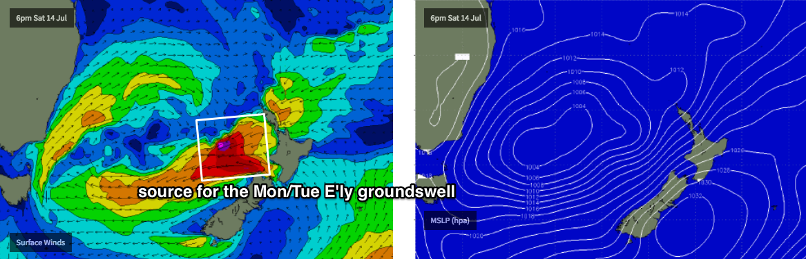
Early indications suggest this swell will arrive later Monday afternoon, peaking overnight and trending down through Tuesday, with direction anywhere from the E or E/SE (due to angular spreading).
Size should peak anywhere from 3ft+ in the north up to 5-6ft+ across the Far South. This is a much broader size range for Southern NSW than I feel comfortable with forecasting (I'd rather tighten up the specifics), but with an easterly swell direction, a light offshore wind and clean conditions throughout there should be plenty of waves on offer right across Southern NSW (there’ll be some small residual S’ly swell in the mix too). However I’m only expecting a brief pulse of energy from this source so let’s take a closer look in Friday’s outlook, as a small kink in the fetch alignment between now and the weekend could dramatically alter this projection.
It's also worth noting that this estimate is almost double what the models are calling for some regions around this time. So, confidence is certainly not high right now, but I'd pencil it in the diary if you have some flexi-time.
Looking further ahead and another strong series of winter fronts are expected across the SE corner of the country mid-next week which suggests the back half of next week and the following weekend will be flush with strong south swells as another Long Wave Trough moves across our longitudes.
See you Friday!