Small flukey swells for the foreseeable future

Sydney, Hunter and Illawarra Surf Forecast by Ben Matson (issued Friday 29th June)
Best Days: Sun/Mon: small south swell at south swell magnets. Tues/Wed/Thurs: small E/NE swell (may be upgraded over the coming days, stay tuned).
Recap: Surf size eased through Thursday with clean 2-3ft surf on offer, and in similarity to Wednesday, today has seen wave heights push higher than expected with clean 2ft+ waves across open beaches (though size is now well and truly on the way down). Conditions improved on Thursday as winds swung offshore and today’s been silky smooth under a westerly flow.
Today’s Forecaster Notes are brought to you by Rip Curl
This weekend (June 30 - July 1)
Want to receive an email when these Forecaster Notes are updated? Then log in here and update your preferences.
Note: Today’s Forecaster Notes will be brief, as Craig is away on annual leave
I’m still not expecting much size on Saturday. Our swell windows have been devoid of activity over the last few days so the only energy in the water will be leftover, easing swell from today. Conditions will however be clean with fresh and gusty offshore winds.
During Saturday a vigorous front will exit eastern Bass Strait. Now that we’re less than a day from its formation, we can be much more confident in the model output, which has now split the difference between previous guidance - but fortunately still retains a slightly southerly component to the overall westerly flow.
This will kick up a fresh south swell for Sunday, though it’ll only get into a handful of exposed south swell magnets as it glances the coast - mainly the Hunter region. Also, the timing has been pulled back a smidge so we may not see much energy at first light, you’ll be better off aiming for lunchtime onwards.
The Newcastle/Central Coast region always does the best under these patterns, and we should see occasional 2-3ft sets through the afternoon. South facing beaches in Sydney will be smaller, with very inconsistent 2ft sets and everywhere else will be considerably smaller again.
The only risk we have is that a smaller southerly breeze may develop throughout the middle of the day, however it’s unlikely to have a lot of strength. It may just take the sheen off things from what should otherwise be a clean round of small surf.
Next week (July 2 onwards)
Long term, the charts aren’t looking especially great for Southern NSW into next week. The Southern Ocean is gearing up for an extended round of winter fronts through the Bight and this invariably puts the upper level steering winds on the wrong side of our swell window - pushing storm activity away from us.
There are a couple of flukey swell sources that’ll keep us busy on the forecasting bench though. A trailing fetch through eastern Bass Strait on Sunday should maintain small southerly swells at south swell magnets into Monday (as per Sunday).
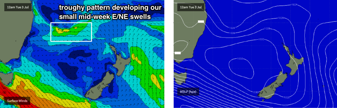
A small trough developing off the SE Qld coast around Monday has been upgraded over the last few model runs, and although it’s expected to focus its attention towards Northern NSW, we should see a resulting E/NE swell spread back down into Southern NSW from Tuesday, building towards a peak on Wednesday before easing into Thursday. Models are in agreement about the pattern but divergent on the specifics, so I’ll peg size around 2-3ft and refine this outlook in the comments below (over the weekend) as new information comes to hand.
Otherwise, the next round of significant activity probably won’t be until the Long Wave Trough slides east of Tasmania later next week and into the weekend, which will probably herald the beginning of an extended period of strong southerly swells (and windy conditions from the SW quadrant) through into the early to middle part of the following week.
That’s still quite some time away though, so let’s take a closer look on Monday. Have a great weekend!