Great waves Friday, easing swells for the weekend, sustained run of solid S'ly swell next week

Sydney, Hunter and Illawarra Surf Forecast by Ben Matson (issued Wednesday 11th April)
Best Days: Thurs/Fri: plenty of strong SE swell but N'ly winds will create tricky conditions Thursday, however Friday will see the best conditions with NW winds. Sat/Sun: small residual swells with offshore winds. Mon onwards: series of overlapping south swells, becoming quite large at south facing beaches Wed onwards.
Recap: Tuesday offered nondescript surf across the region with mid range S’ly swells and early light winds that swung to the north. Today’s seen a large SE swell build across the coast, ahead of forecast expectations but generally inline with size estimations of 4-6ft. Today's exception is the Illawarra coast, which has seen much larger surf pushing 6-8ft at times (interestingly, the biggest waves from this system were expected north from Sydney, which these observations obviously contradict). Buoy data from Sydney and Pt Kembla also supports this disparity in size across such a small geographic region. Winds were light NW early but have freshened from the north throughout the day.
Today’s Forecaster Notes are brought to you by Rip Curl
This week (Apr 12th - 13th)
There’s still plenty of SE swell to come, originating from a few sources in and around the southern tip of New Zealand a few days ago.
A second pulse of SE groundswell from the Tasman Low (related to the fetch that generated today’s swell) will provide solid surf through Thursday, before a smaller but slightly longer period SE swell then arrived in the early hours of Friday morning, generated by a polar low positioned to the S/SE of New Zealand earlier this week.
Despite Thursday seeing the most size (4-6ft sets south facing beaches, smaller elsewhere), local winds will remain an issue for most Southern NSW breaks and thus quality options will be hard to find. We’re looking at freshening N/NE breezes throughout the day. There’s an outside chance for isolated regions of early N/NW winds but it won’t be enough totally clean up the bumps from overnight northerlies.
In fact, the N’ly breeze developing today will also generate 2-3ft of peaky NE swell for open beaches on Thursday. This will delineate the SE lines and may offer some interesting peaks but you’ll ultimately have to tuck into a northern corner for the best conditions.
Friday will see a drop in size, though some reinforcement from the new SE groundswell though maintain size between 3ft and 5ft at exposed spots. There should however be a more prominent decrease in the swell’s consistency, so bear this in mind.
Though, with the northerly humming through Thursday we’ll see NE windswells persisting into Friday, though probably a little smaller than Thursday (maybe 2ft+).
Friday looks much better on the surface though with winds swinging to the NW as a weak trough moves over the area. This should clean up the beachies nicely and provide some excellent waves to finish the working week.
This weekend (Mar 14th - 15th)
Fantastic surface conditions are expected all weekend though you will have to make the most of Saturday as wave heights will be on the way out pretty quickly.
Friday’s SE swell will ease back to 2-3ft by Saturday morning - perhaps some bigger sets at south facing beaches between Sydney and the Hunter around dawn - and is likely drop further throughout the day with only small conditions expected on Sunday.
Conditions will be super clean with moderate to fresh NW winds Saturday swinging W’ly then W/SW into Sunday. So, it’ll be super smooth.
We’re still on track for a small flush of south swell later Sunday, originating from gale force W/SW winds exiting eastern Bass Strait overnight Saturday, but it’s a line call at the moment (any more west in the fetch and we won’t see anything). At this stage I’ll peg a few late 2ft+ sets at reliable south swell magnets.
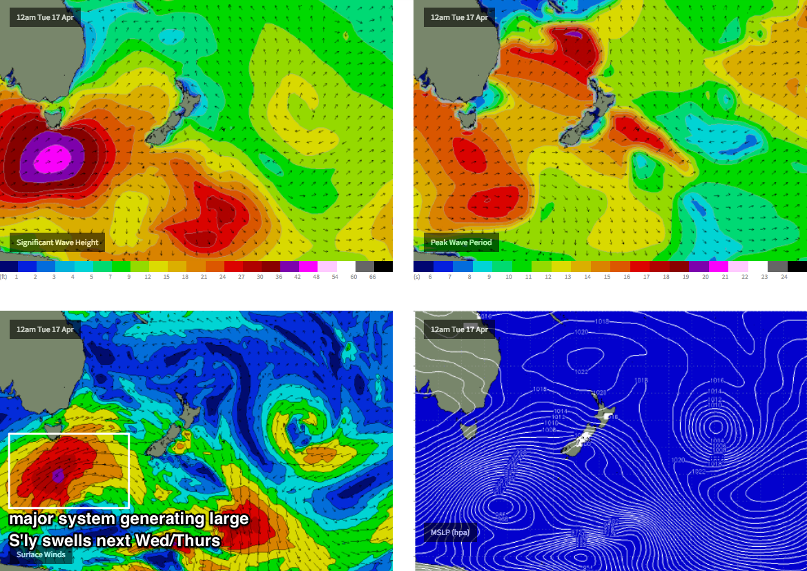
Next week (May 16th onwards)
The Southern Ocean is gearing up for a very active run next week, with a series of powerful low pressure systems to cross the Tasmanian region.
Initially, they’ll be strongly zonal in alignment (west-east) which will limit size potential in Southern NSW - south facing beaches are likely to fluctuate in the 3-4ft range on Monday and Tuesday.
However, a very broad, strong polar fetch pushing NE from the ice shelf early in the week looks like it’ll generate a very large south swell from Wednesday to Friday. There’ll be a wide range in size across the region thanks to the acute southerly swell direction, but south facing beaches should push north of 6-8ft through this time frame, with significantly bigger waves at offshore bombies thanks to a large swell period.
Even better, these patterns are usually associated with prolonged stints of W/SW winds, keeping conditions nice and clean across most coasts.
This looks like a pretty serious series of south swells, so will be well worth putting some time aside next week - there’ll be waves every day, but Wednesday onwards will have the most size.
See you Friday!
Comments
With all the debate about surf reports I received this from a mate this arvo.he surfed curl curl
Much like a nubile 18 yr old, promised so much, yet went home to spank yourself. Or is that just Curly, or rather the short & Curly's.
Your either on it or under it. Plus current.
Haha that's just Curl Curl, a couple of spots were cooking all day!
Illawarra outperformed on a south swell! Is this a first? I can vouche that it was indeed solid.