Tricky weekend waves, next week looks unreal

Sydney, Hunter and Illawarra Surf Forecast by Ben Matson (issued Friday 23rd March)
Best Days: Sat/Sun: brief pockets of OK surf, early mornings. Mon: offshore winds, easing easing NE windswell. Tues/Wed: fun S'ly swell. Thurs/Fri/Sat: great E/NE swell.
Recap: Large, wind affected surf for the last few days, improving through this afternoon as local winds have abated.
Today’s Forecaster Notes are brought to you by Rip Curl
This weekend (Mar 24th - 25th)
Freshening northerly winds will take the sheen off the weekend’s waves.
There won’t be any shortage of size though.
Today’s large, easing swell will be supplemented by a new SE swell from a secondary low that developed off the SW tip of New Zealand’s South Island later Wednesday. Additionally, we’ll see some mid-range E/NE energy from a fetch that was NE of New Zealand earlier in the week - partially inside our swell shadow, but with enough scope for a minor increase from this quadrant.
This mix of swells should ensure wave heights manage 3-5ft at open beaches through Saturday morning, though it's likely to ease into the afternoon, down to 2-3ft+ into Sunday. In fact, Saturday afternoon’s N’ly tending NE winds will whip up some windswell for Sunday (more so Monday), just to add some spice into the mix.
There’s a chance for isolated regions of NW winds both mornings - more so Sunday than Saturday, though broadly speaking, wind strengths will be lighter Saturday so we may also see pockets of variable winds for the early session here.
However in general there’ll be a freshening northerly flow and associated surface wobble. Afternoons in particular will be bumpiest so aim for a morning session.
Next week (Mar 26th onwards)
Monday’s had a minor improvement to the outlook with the afternoon southerly change delayed and downgraded. It won’t arrive until overnight Monday, so winds will be offshore for much of the day.
Surf size will ease from the SE and E/NE, but there’ll be some peaky NE windswell reaching 2-3ft+ at reliable NE swell magnets early Monday morning before we see size abating throughout the day. Expect much smaller surf at south facing beaches, and across the northern Hunter.
Long term prospects remain dynamic. Tuesday and Wednesday will both see varying degrees of S’ly swell from a mid-latitude low crossing the Tasmanian region around Monday. Initially, we’ll see a S’ly pulse Tuesday from a gale force W/SW fetch exiting eastern Bass Strait, followed by a second S’ly swell Wednesday from the parent low well to the SE.
South facing beaches should manage some 3ft sets from both sources around this time frame, though I’ll fine tune on Monday as it’s a flukey swell source. Expect very small surf away from south swell magnets these days.
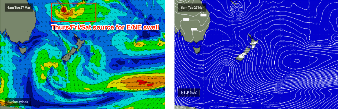
As this is going on, we’ll see a Tropical Low or Cyclone in the Coral Sea track south from a position near New Caledonia (models have the cyclone path right over the top of NC, actually!), before it merges with a ridge to the south-east, just north of New Zealand.
This system is expected to slowly intensify whilst remaining near-stationary, which is excellent for Southern NSW surf prospects.
At this stage we’re looking at E/NE swell building slowly to 2-3ft through Wednesday afternoon (from the early incarnation of the ridge) before stronger E/NE energy from the cyclone/strengthening ridge makes landfall, which could reach 4-5ft+ at NE facing beaches by Friday (smaller Thursday).
Additionally, this system is expected hold position for a few days so we should see persistent energy into next weekend too. Though, it’s too early to have confidence as to whether we’ll see the size hold, increase or decrease.
See you Monday!
Comments
Nice forecast Ben! I appreciate how you talked down this weekends forecast in Wednesday's notes, and even today there is a sense of 'don't get too excited'. From what I can see it's going to be a cracka of a weekend of waves. My personal frothoclock is telling me its time for some 3-4 foot (sure, not real big but very fun) offshore gems AM tomorrow and Sunday. Hope you get a few :) Cheers!