Plenty of waves ahead for Southern NSW

Sydney, Hunter and Illawarra Surf Forecast by Ben Matson (issued Wednesday 14th March)
Best Days: Plenty of good waves most days, except Sat PM and Sun when we'll see average conditions under freshening N'ly winds.
Recap: Moderate easterly winds took the sheen off a building combo of south swells on Tuesday, with size building to 3-4ft through the afternoon. A new E’ly swell also arrived through the afternoon offering 3-4ft sets late afternoon. Both the south and east swells have provided 3-4ft+ sets across most beaches today, and there have been larger bombs reported at a handful of reliable swell magnets. This morning’s winds were much better being light out of the west, but they have since freshened from the NE.
Today’s Forecaster Notes are brought to you by Rip Curl
This week (Mar 13 - 16)
Today’s easterly and southerly swell combo will ease through Thursday, though we should see early 3ft sets at some exposed beaches. These swells will ease steadily into the afternoon, and it’ll be generally clean early with light NW winds into the morning, tending N’ly throughout the day ahead of a late S’ly change (earlier across the South Coast) as a weak trough slides up the coast.
We have a couple of flukey new swell sources expected over the coming days though.
First off is a small, unreliable NE swell from ex-TC Linda, from its earlier position in the Coral Sea. In general I don’t think it’ll influence many beaches, mainly due to the acute direction and heavy refraction - past Seal Rocks - required to get in to Southern NSW, which will effectively rule out most beaches north from Sydney to the Hunter. South from Sydney (South and Far South Coasts) may pick up occasional waves but it’ll be the exception rather than the rule, perhaps the odd 2-3ft set if we’re lucky.
This swell is expected to arrive later Thursday and then persist (similarly erratically) through Friday as the direction veers more E/NE, thanks to a portion of (now ex) TC Linda that’s modeled to move S/SE away from the primary system later today and into tomorrow. In fact this should continue to supply swell through Saturday, and as the direction tends more E/NE (through Friday) it may start to influence a few more beaches, including the Sydney-Hunter stretch. Though, it’s a low confidence event right now.
The other swell source is a deep Southern Ocean low to the SW of Tasmania, right on the periphery of our flukey south swell window. Since Monday’s notes were written, model guidance has backed off the strength of this system and also pushed it a little more outside of our swell window which has decreased confidence for this to be anything out of the ordinary. As it is, the leading edge isn’t expected into the South Coast until midday Friday, and we won’t see an appreciable pulse across Sydney beaches until the last few hours of the day. As such keep your expectations low (and aim for Saturday, if you’re dialling into a south-friendly location).
This means Friday’s waves will mainly consist of small leftovers, with some intermittent E/NE energy showing across a handful of beaches throughout the day. Moderate lingering southerly winds are possibly across some coasts - so keep your expectations appropriately low for the early session - though they’ll ease steadily and by lunchtime should be variable. Sea breezes are likely after lunch.
This weekend (May 17 - 18)
Make the most of Saturday morning. We’ll see small unreliable E/NE energy across a few beaches (2-3ft if we’re lucky) but the main source will be an acute south swell that’s going to favour south facing beaches with 3-4ft+ surf, bigger across the Hunter around 4-6ft.
A strengthening Tasman high will freshen northerly winds all weekend. They’ll be light and possibly NW early Saturday but will start to affect wave quality throughout the day, and by Sunday they’ll be quite gusty at times.
These winds will whip up some NE windswell for Sunday (biggest in the afternoon) but quality is not expected to be very high, and Saturday’s south swell will have eased considerably - perhaps some 2-3ft sets at south swell magnets early, smaller throughout the day.
Next week (May 19 onwards)
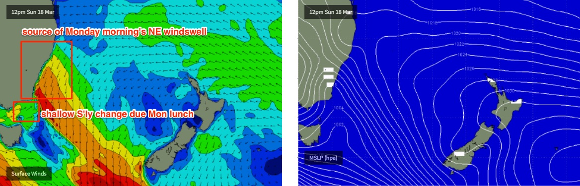
Monday morning looks really good. An approaching shallow southerly change is expected to create a period of early offshore winds (before it tend S’ly by lunchtime) and Sunday’s building NE swell is expected to reach a peak with 3-4ft sets at reliable NE facing beaches (smaller across the Hunter). Southern ends should see good surf into the afternoon once the winds swing, though it's not expected to be too strong.
Other swell sources for next week include a long lived, slowly increasing E/NE swell from a broad ridge stretching through the NE Tasman Sea out into the South Pacific, which may also see a tropical some form to its north mid-week and provide larger, longer period energy later next week and into the weekend.
Additionally, a series of poorly aligned but very strong Southern Ocean fronts will supply a strong S'ly change Tuesday, and then intermittent pulses of southerly groundswell throughout the second half of week.
More on this in Friday’s update.
Comments
South coast not seeing any increase in swell. In fact, looks like a bit of a lake out there.
All models don't seem to show any appreciable increase either - are we still expecting something? I do note that BOM has issued a surf warning for late today / tomorrow morning.
The swell hit Point Nepean later than expected, so perhaps a delay up here too?
Sydney model has leading edge arriving by 6pm (16.4 seconds).. if it's just a few hours delayed then we won't see anything until after sunset (the bulk swell wasn't expected until Sat anyway). Latest data from Eden is 11:00am (Batemans buoy is offline) so we really need a few more hours before assessing the initial stage of this swell. Cape Sorell (Tas west coast) buoy data looks good though.