Plenty of SE swell all week; tricky winds until the weekend

Sydney, Hunter and Illawarra Surf Forecast by Ben Matson (issued Monday 5th March)
Best Days: Plenty of waves each and every day but SE winds will create problems through the middle of the week. Best conditions later this week and weekend as winds ease.
Recap: Nothing special over the weekend. Small S’ly swells eased throughout, and we’ve seen little increase in windswell behind yesterday’s southerly change (which, for reference, reached the Northern Beaches around 9am), with small southerly swells and southerly winds persisting into today.
Today’s Forecaster Notes are brought to you by Rip Curl
This week and weekend (Mar 6 - 11)
Big model downgrade regarding this week’s modeled ECL.
In short: the entire pattern has been shunted form the south-western Tasman Sea to the north-eastern Tasman Sea, and its overall alignment has been tweaked clockwise out of our swell window.
Today’s cross-onshore winds weren’t that strong but they’ll muscle up into Tuesday as a ridge builds across the East Coast. The strongest part of the ridge will be due east of Sydney, but way out in the eastern Tasman Sea, aimed up towards New Caledonia. So, we’ll see a small spread of SE swell from this source through the middle of the week.
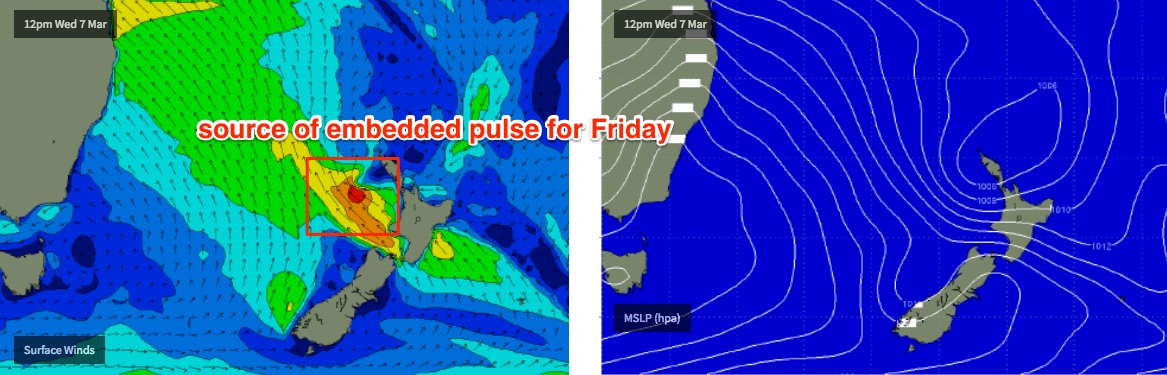
The ridge will then hold firm across the Northern Tasman Sea through the rest of the week and even into the weekend, though in general it’ll poorly aimed for our coastline. A few small regions will briefly develop favourable swell generating fetches - first one is an E/SE fetch exiting western Cook Strait (between NZ’s North and South Islands) later Wednesday, though the energy we see from this source (arriving around Friday) will only be slightly above that of the background swell spread from the ridge.
Elsewhere, a series of strong Southern Ocean fronts - whilst providing small underlying southerly groundswell from mid-week onwards - will also momentarily strengthen S’ly fetches off the SW tip of New Zealand’s South Island. The first event doesn’t look very promising but the second event - later Thursday or Friday - may provide a small S/SE swell for the weekend. But again, probably not much more than the existing background trade swell energy.
The best fetch for our region (currently) looks like it’ll develop out of western Cook Strait around Friday, generating a slightly better E/SE swell for Sunday or thereabouts. But it’s a long time away and I’m doubtful we’ll see any great size across our coast.
The Northern Tasman Sea ridge will also align slightly more favourable for our swell window later this week which will generate useful E/NE swells through the weekend and early next week too.
As for size all week, we’re looking fluctuations either side of 2-3ft. Tuesday will probably fall just below this, but Wednesday should see a healthy spread of energy from the building ridge and may punch just north of this figure (especially through the Hunter) up towards 3-4ft (slightly smaller surf as you track south from Sydney).
However, surface conditions won’t be great with mainly SE winds. We’ll see lighter winds south from Sydney (which increases the chances of early light SW winds too) but in general it’ll be a mixed bag in the conditions department.
Surf size will probably fluctuate in and around the 2-3ft range through the second half of the week and the weekend too (with a couple of embedded bigger pulses, around Friday and Sunday). Local winds will ease later this week to become light and variable by Saturday, so there’ll be better surfing opportunities around this time as conditions improve.
As a side note: it looks like we’ll see a tropical cyclone develop near Vanuatu over the coming days, but it doesn’t look like being a swell producer for us, for a couple of reasons: (1) too small in diameter and too far from the mainland, (2) it's expected to spend its early days inside the swell shadow of New Caledonia; (3) it also races too quickly across a perpendicular track through to New Zealand. I’ll keep a watch on it though.
Next week (Mar 12 onwards)
Looks like a dynamic long range outlook, with plenty of swell sources to keep monitoring: a strong Southern Ocean front approaching Tasmania, a large, somewhat unrelated polar low S/SE of New Zealand, and some potential tropical cyclone activity in the Coral Sea will all keep us on our toes. Nothing concrete yet though.