Small peaky swells all week; lengthy period of fun trade swell from Sunday onwards

Sydney, Hunter and Illawarra Surf Forecast by Ben Matson (issued Monday 22nd January)
Best Days: No great days this week due to a lack of size. Monday (next week) onwards looking much better as the trade swell kicks in.
Recap: Small leftovers for the last three days, nothing special at all. Size around the 1-2ft range each day (a few slightly bigger sets Sat), with the direction clocking from the SE to the E then NE. Winds have generally been out of the N thru' NE.
Today’s Forecaster Notes are brought to you by Rip Curl. And hey! We’ve got an extended period of NE winds ahead, which means some upwelling and thus rapidly fluctuating water temps. Time you sorted that autumn fav, the short arm steamer, sooner rather than later. Clicky here for more!
This week (Jan 23rd - 26th)
Not much to see this week. A stationary synoptic pattern will maintain moderate NE winds across the coastal margin from now thru’ next Monday (if that eventuates, it’ll be eleven consecutive days out of the northern quadrant, since last Friday).
Wind speeds won’t be enough to generate any major size though we’ll see wave heights fluctuate either size of 2ft+; with a few periods slightly bigger, and a few periods slightly smaller. Obviously, you’re more interested in the former rather than the latter, though to be honest wave heights are more likely to to ebb and flow with the tide more than anything else - so there’s no clear definitive window as to when we’ll see worthwhile conditions (or at least, the biggest waves). Especially with the wind generally out of the same quadrant.
Model guidance also has some minor long period southerly energy in the mix throughout the week too, though it’s sourced from very distant Southern Ocean storms and thus won’t contribute much in the way of size or consistency. Tuesday looks to be the most promising day for this small south swell, with Thursday seeing a minor renewal of energy.
Overall, there should be small peaky waves each day but it’s probably not worth too much time and effort if you’re not already planning to be in the vicinity of the beach.
This weekend (Jan 27th - 28th)
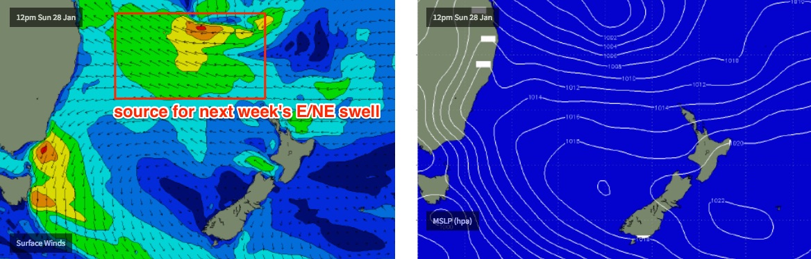
Nothing great expected this weekend either, however we’ll have some synoptic developments further north that will start to influence our coast ahead of a much better swell outlook for next week.
A stationary Tasman high pressure system will interact with a southward-tracking tropical low in the Coral Sea later this week, strengthening easterly winds through the Northern Tasman Sea and generate trade swells for the east coast.
Initially they’ll be small in size through the weekend, but they’ll contribute some small energy to the mix along with small, persistent NE windswells similar to what we’re expecting for much of this week.
Again, winds will remain out of the NE so conditions aren’t looking great, but there’ll be a slightly better blend of peaky surf to pick and choose from this weekend. Only problem will be the ongoing NE breeze but at least there’ll be small peaky waves. At this stage Saturday looks to be around the 2ft+ mark, lifting to 2-3ft+ throughout Sunday as the trade swell becomes more of an influence.
Next week (Jan 29th onwards)
The southward-tracking tropical low is expected to anchor itself in the Northern Tasman Sea for some time. Which means an extended run of E’ly swell for our northern brethren, with slightly smaller, more E/NE swell for our region.
Wave heights should lift from 2-3ft+ to 3-4ft+ early next week, and will likely persist aorund this range for at least two or three days. I wouldn't be surprised if we see this tropical low develop more fully over the coming days and deliver a bigger pulse of swell around the middle of next week, several feet higher than the background energy. But it's still very early in the forecast schedule.
In fact, the longer term model guidance suggests there’s a whole lotta tropical activity to bear down through the Coral Sea for the next few weeks, all of which points to two or three weeks of fluctuating trade swell from the east and northeast.
Ain’t it good to have our summer trade swells back on the horizon! We’ve missed ya, big fella.
Comments
Most promising forecast in ages! Huey must of got over his Xmas hangover.
Did you sleep through last week?
Mate. I saw one spot working with 30 blokes out last week and I was working
If '' Most promising forecast in ages'' includes cold upwelling, weak wind swells and good chance of Bluebottles, yippee, Im creaming my pants, just thinking about it!
Thanks Ben, for best report, like Ever!
Gee I don't know mate! Any forcast that has the chance of any NE swell over 2 -3ft is joy..
If a NE swell hits 4 ft then ever beach break becomes rippable fun +some.
Add a touch more with a little offshore and those conditions turn most east coast beaches into south straddy..
Looks good to me and I just spent the whole autumn/winter surfing epic 6-8ft winki and bells...
jeez, what a grouch fest.
It's funny Nick as most of the people who complain about average waves and don't surf those days.
Can't surf when it actually gets goods anyway as there to unfit and relegated to the shoulder to yell at "blow ins" for catching waves on the proper take off while they pretend to be the hellman! But today they can't surf because who else is going regulate the blowins!
Taking off too deep.
That makes no sense
Fair enough.
Hahahaaa classic! Yeah after all the hype it was dismal round here last week n weekend, as expected from another tasman low with shit swell and wobbly stormsurge tides. I dont think its a grouch fest here I just think theres a lot to be concerned about when the outlook is for shitty tradeswells for the foreseeable future. Like Wazzlepop says windswells and bluebottles . Great.
What region are you in mate? Was pumping between Wollongong and Kiama for that swell
I'm in a very different region mibs. I lived in Gong for 20 years and I can see how it would've been different there. Theres not that much difference in a windswell and a groundswell in the Gong . Not much difference in pumpin and crap.
Hi Ben, do you think we'll get some swell this weekend from the trades and slight dip that have been loitering E/NE of NZ over the past couple of days or has the wind strength not been sufficient? Cheers
Good pick up.
I mentioned this system in last week's notes, but given the complexity of the synoptics from Thurs/Fri onwards (meaning any swell from the developing trades and/or Coral Sea system could arrive around the same time as the swell from the South Pacific trough), I was reluctant to go into too much more detail for a swell that ultimately may not be visible anyway.
Truth be told, I had a super hectic day yesterday and was running very late by the time I got on to the Forecaster Notes, so also didn't want to spend much time on a (potentially) superflous weather system. But in hindsight, there's always a chance the models could slow down the Coral Sea movements, and that the SPac long range swell could end up being a dominant source for a period of time, albeit small and inconsistent.
So yeah, no major change to last Friday's outlook for this energy - arriving over the weekend (more likely Sun than Sat) with occasional 2-3ft sets.
Thanks Ben, it might help muscle up the near period stuff. And I loiter on the far south coast so we do alright out of NE windswell anyway.
Keep up the great work.
Ps truth be told I'm an inland surfer with a young child so I've been sweating on this system since the early new year for another chance at a wave :-)
Ah yes the westy a glass is always half full type!
So am I... and you are my favorite type of surfer to catch a wave with no matter what you level..
It's always 6ft and offshore if you only get a wave a couple of times a month hey...
Born and bred far west Victoria thank you very much, so a slightly different type of westy to what you are probably familiar with ;-) But yes I get around, including being that Melbourne based surfer that has been despised in a few Vic threads but now I choose a location to make a quid and easily indulge in another board riding passion :-)
Sorry probably didn't need the 'thank you very much' but I don't like being called a westy, familiar with that term ;-)
I was born and bred in an ocean town... But yes I'm the glass half full type, life's too short otherwise.
The forecast next week showing a sustained period of swell of over 10ft for NSW. This has been changing a lot through the course of the week but holy s#*t its a pretty intense looking weather pattern building in the Tasman. Much confidence in this playing out?
i got best waves in ages last monday . best lefts . pits everywere . bit of blowins but thay all shit . id post a picture but cant . bellambi beach was firing monday . love the ne swells build the banks then a south swell comes n lights up